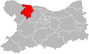
Kanton Bayeux
| Kanton Bayeux | |
|---|---|
| Geografie | |
| Hlavní město | Bayeux |
| Souřadnice | 49°16′43″ s. š., 0°42′14″ z. d. |
| Rozloha | 193,33 km² |
| Obyvatelstvo | |
| Počet obyvatel | 29 283 (2009) |
| Hustota zalidnění | 151,5 obyv./km² |
| Správa regionu | |
| Stát | |
| Region | Normandie |
| Departement | Calvados |
| Arrondissement | Bayeux, Caen |
| Druh celku | Kanton |
| Podřízené celky | Obce (počet: 34) |
| Vznik | 22. března 2015 |
| Některá data mohou pocházet z datové položky. | |
Kanton Bayeux (fr. Canton de Bayeux) je francouzský kanton v departementu Calvados v regionu Normandie. Od roku 2015 se skládá ze 34 obcí, do té doby byl tvořen 16 obcemi.
Obce kantonu
- Agy
- Arganchy
- Barbeville
- Bayeux
- Campigny
- Chouain
- Commes
- Condé-sur-Seulles
- Cottun
- Cussy
- Ellon
- Esquay-sur-Seulles
- Guéron
- Juaye-Mondaye
- Longues-sur-Mer
- Magny-en-Bessin
- Le Manoir
- Manvieux
- Monceaux-en-Bessin
- Nonant
- Port-en-Bessin-Huppain
- Ranchy
- Ryes
- Saint-Loup-Hors
- Saint-Martin-des-Entrées
- Saint-Vigor-le-Grand
- Sommervieu
- Subles
- Sully
- Tracy-sur-Mer
- Vaucelles
- Vaux-sur-Aure
- Vaux-sur-Seulles
- Vienne-en-Bessin
Obce kantonu (do roku 2015)
- Agy
- Arganchy
- Barbeville
- Bayeux
- Cottun
- Cussy
- Guéron
- Monceaux-en-Bessin
- Nonant
- Ranchy
- Saint-Loup-Hors
- Saint-Martin-des-Entrées
- Saint-Vigor-le-Grand
- Subles
- Sully
- Vaucelles
Média použitá na této stránce
Autor: Pymouss, Licence: CC BY-SA 4.0
Carte de localisation du canton de Bayeux dans le Calvados.


