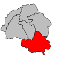
Kanton Courpière
| Kanton Courpière | |
|---|---|
| Geografie | |
| Hlavní město | Courpière |
| Souřadnice | 45°45′17″ s. š., 3°36′29″ v. d. |
| Rozloha | 209,15 km² |
| Obyvatelstvo | |
| Počet obyvatel | 8 042 (2012) |
| Hustota zalidnění | 38,5 obyv./km² |
| Správa regionu | |
| Stát | |
| Region | Auvergne |
| Departement | Puy-de-Dôme |
| Arrondissement | Thiers |
| Druh celku | Kanton |
| Podřízené celky | Obce (počet: 10) |
| Některá data mohou pocházet z datové položky. | |
Kanton Courpière (fr. Canton de Courpière) je francouzský kanton v departementu Puy-de-Dôme v regionu Auvergne. Tvoří ho 10 obcí.
Obce kantonu
- Aubusson-d'Auvergne
- Augerolles
- Courpière
- Olmet
- La Renaudie
- Sainte-Agathe
- Sauviat
- Sermentizon
- Vollore-Montagne
- Vollore-Ville
Média použitá na této stránce
Autor: Michiel1972, Licence: CC BY-SA 3.0
Location of the canton within its arrondissement.


