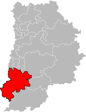
Kanton Fontainebleau
| Kanton Fontainebleau | |
|---|---|
| Geografie | |
| Hlavní město | Fontainebleau |
| Souřadnice | 48°24′32″ s. š., 2°42′6″ v. d. |
| Rozloha | 528,28 km² |
| Obyvatelstvo | |
| Počet obyvatel | 64 175 (2012) |
| Hustota zalidnění | 121,5 obyv./km² |
| Správa regionu | |
| Stát | |
| Region | Île-de-France |
| Departement | Seine-et-Marne |
| Arrondissement | Fontainebleau (24 obcí) Melun (10 obcí) |
| Druh celku | Kanton |
| Podřízené celky | Obce (počet: 34) |
| Vznik | 2015 |
| Některá data mohou pocházet z datové položky. | |
Kanton Fontainebleau (fr. Canton de Fontainebleau) je francouzský kanton v departementu Seine-et-Marne v regionu Île-de-France. Tvoří ho 34 obcí. Před reformou kantonů 2014 ho tvořilo 7 obcí.
Obce kantonu
od roku 2015:
|
|
před rokem 2015:
- Avon
- Bois-le-Roi
- Fontainebleau
- Héricy
- Samois-sur-Seine
- Samoreau
- Vulaines-sur-Seine
Externí odkazy
- Kanton Fontainebleau na stránkách INSEE
Média použitá na této stránce
Autor: Pymouss, Licence: CC BY-SA 4.0
Carte de localisation du canton de Fontainebleau en Seine-et-Marne.


