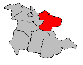
Kanton Lavelanet
| Kanton Lavelanet | |
|---|---|
| Geografie | |
| Hlavní město | Lavelanet |
| Souřadnice | 42°56′1″ s. š., 1°50′58″ v. d. |
| Rozloha | 286,09 km² |
| Obyvatelstvo | |
| Počet obyvatel | 12 854 (2010) |
| Hustota zalidnění | 44,9 obyv./km² |
| Správa regionu | |
| Stát | |
| Region | Midi-Pyrénées |
| Departement | Ariège |
| Arrondissement | Foix |
| Druh celku | Kanton |
| Podřízené celky | Obce (počet: 21) |
| Některá data mohou pocházet z datové položky. | |
Kanton Lavelanet (francouzsky Canton de Lavelanet) je francouzský kanton v departementu Ariège v regionu Midi-Pyrénées. Tvoří ho 21 obcí.
Obce kantonu
- L'Aiguillon
- Bélesta
- Bénaix
- Carla-de-Roquefort
- Dreuilhe
- Fougax-et-Barrineuf
- Ilhat
- Lavelanet
- Lesparrou
- Leychert
- Lieurac
- Montferrier
- Montségur
- Nalzen
- Péreille
- Raissac
- Roquefixade
- Roquefort-les-Cascades
- Saint-Jean-d'Aigues-Vives
- Sautel
- Villeneuve-d'Olmes
Média použitá na této stránce
Autor: Michiel1972, Licence: CC BY-SA 3.0
Location of the canton within its arrondissement.


