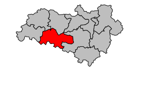
Kanton Mansle
| Kanton Mansle | |
|---|---|
| Geografie | |
| Hlavní město | Mansle |
| Souřadnice | 45°52′37″ s. š., 0°10′46″ v. d. |
| Rozloha | 242,13 km² |
| Obyvatelstvo | |
| Počet obyvatel | 8 906 (2009) |
| Hustota zalidnění | 36,8 obyv./km² |
| Správa regionu | |
| Stát | |
| Region | Poitou-Charentes |
| Departement | Charente |
| Arrondissement | Confolens |
| Druh celku | Kanton |
| Podřízené celky | Obce (počet: 26) |
| Některá data mohou pocházet z datové položky. | |
Kanton Mansle (fr. Canton de Mansle) je francouzský kanton v departementu Charente v regionu Poitou-Charentes. Skládá se z 26 obcí.
Obce kantonu
- Aunac
- Bayers
- Cellefrouin
- Cellettes
- Chenommet
- Chenon
- Fontclaireau
- Fontenille
- Juillé
- Lichères
- Lonnes
- Luxé
- Mansle
- Mouton
- Moutonneau
- Puyréaux
- Saint-Amant-de-Bonnieure
- Saint-Angeau
- Saint-Ciers-sur-Bonnieure
- Sainte-Colombe
- Saint-Front
- Saint-Groux
- La Tâche
- Valence
- Ventouse
- Villognon
Média použitá na této stránce
Autor: Michiel1972, Licence: CC BY-SA 3.0
Location of the canton within its arrondissement.


