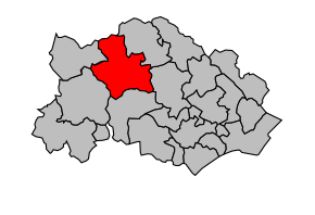
Kanton Olargues
| Kanton Olargues | |
|---|---|
 | |
| Geografie | |
| Hlavní město | Olargues |
| Souřadnice | 43°32′50″ s. š., 3°0′22″ v. d. |
| Rozloha | 283,37 km² |
| Obyvatelstvo | |
| Počet obyvatel | 4 327 (2010) |
| Hustota zalidnění | 15,3 obyv./km² |
| Správa regionu | |
| Stát | |
| Region | Languedoc-Roussillon |
| Departement | Hérault |
| Arrondissement | Béziers |
| Druh celku | Kanton |
| Podřízené celky | Obce (počet: 12) |
| Některá data mohou pocházet z datové položky. | |
Kanton Olargues (francouzsky Canton d'Olargues) je francouzský kanton v departementu Hérault v regionu Languedoc-Roussillon. Tvoří ho 12 obcí.
Obce kantonu
- Berlou
- Cambon-et-Salvergues
- Colombières-sur-Orb
- Ferrières-Poussarou
- Mons
- Olargues
- Prémian
- Roquebrun
- Saint-Étienne-d'Albagnan
- Saint-Julien
- Saint-Martin-de-l'Arçon
- Saint-Vincent-d'Olargues
- Vieussan
Externí odkazy
 Obrázky, zvuky či videa k tématu Kanton Olargues na Wikimedia Commons
Média použitá na této stránce
Autor: Michiel1972, Licence: CC BY-SA 3.0
Location of the canton within its arrondissement.
Coat of arms of Languedoc and the department of Hérault : Gules cross-keyed, emptied and decorated with twelve gold coins.


