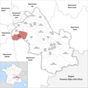
Kanton Roussillon
| Kanton Roussillon | |
|---|---|
 | |
| Geografie | |
| Hlavní město | Roussillon |
| Souřadnice | 45°22′19″ s. š., 4°48′42″ v. d. |
| Rozloha | 211,18 km² |
| Obyvatelstvo | |
| Počet obyvatel | 47 852 (2009) |
| Hustota zalidnění | 226,6 obyv./km² |
| Správa regionu | |
| Stát | |
| Region | Rhône-Alpes |
| Departement | Isère |
| Arrondissement | Vienne |
| Druh celku | Kanton |
| Podřízené celky | Obce (počet: 21) |
| Vznik | 2015 |
| Některá data mohou pocházet z datové položky. | |
Kanton Roussillon (fr. Canton de Roussillon) je francouzský kanton v departementu Isère v regionu Rhône-Alpes. Skládá se z 21 obcí.
Obce kantonu
- Agnin
- Anjou
- Assieu
- Auberives-sur-Varèze
- Bougé-Chambalud
- Chanas
- La Chapelle-de-Surieu
- Cheyssieu
- Clonas-sur-Varèze
- Le Péage-de-Roussillon
- Roussillon
- Sablons
- Saint-Alban-du-Rhône
- Saint-Clair-du-Rhône
- Saint-Maurice-l'Exil
- Saint-Prim
- Saint-Romain-de-Surieu
- Salaise-sur-Sanne
- Sonnay
- Vernioz
- Ville-sous-Anjou
Média použitá na této stránce
Autor: Tschubby, Licence: CC BY-SA 3.0
Lage des Kantons Roussillon
Autor: Michiel1972, Licence: CC BY-SA 3.0
Location of the canton within its arrondissement.


