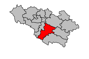
Kanton Saramon
| Kanton Saramon | |
|---|---|
 | |
| Geografie | |
| Hlavní město | Saramon |
| Souřadnice | 43°31′15″ s. š., 0°43′17″ v. d. |
| Rozloha | 188,23 km² |
| Obyvatelstvo | |
| Počet obyvatel | 3 025 (2009) |
| Hustota zalidnění | 16,1 obyv./km² |
| Správa regionu | |
| Stát | |
| Region | Midi-Pyrénées |
| Departement | Gers |
| Arrondissement | Auch |
| Druh celku | Kanton |
| Podřízené celky | Obce (počet: 16) |
| Některá data mohou pocházet z datové položky. | |
Kanton Saramon (fr. Canton de Saramon) je francouzský kanton v departementu Gers v regionu Midi-Pyrénées. Skládá se ze 16 obcí.
Obce kantonu
- Aurimont
- Bédéchan
- Boulaur
- Castelnau-Barbarens
- Faget-Abbatial
- Lamaguère
- Lartigue
- Moncorneil-Grazan
- Monferran-Plavès
- Pouy-Loubrin
- Saint-Martin-Gimois
- Saramon
- Sémézies-Cachan
- Tachoires
- Tirent-Pontéjac
- Traversères
Média použitá na této stránce
Autor: Michiel1972, Licence: CC BY-SA 3.0
Location of the canton within its arrondissement.
Blason (non-officiel attendu que ce département ne revendique pas de blason) du département du Gers : d’argent au lion de gueules.


