Kasei Valles
| Kasei Valles | |
|---|---|
.jpg) Údolí Kasei Valles (Mars Express) | |
| Poloha | 24.6°N 65.0°W |
| Útvar | údolí |
| Max. hloubka | 3 km |
| Rozměr | až 1,780 km |
| Jméno | Slovo Mars z japonštiny. |
Kasei Valles je ohromný systém kaňonů v oblasti Mare Acidalium a Lunae Palus na Marsu. Ohromný systém je rozšířen až po 300 mil, jedná se o jeden z nejdelších odtokových kanálů na povrchu Marsu. Kasei Valles počíná u Echus Chasma poblíž systému Valles Marineris, dále vede na sever a směřuje do Chryse Planitia, nedaleko od místa přistání sondy Viking 1. Ohromné údolí Kasei Valles se dělí na dvě větvě, které obepínají ostrov, nazývaný Sacra Mensa. Některé části Kasei Valles jsou až 2 - 3 km hluboké. Pravděpodobný původ údolí je vytvoření tekutou vodou razící si cestu po povrchu planety, po zahřátí oblasti vulkanickou činností. Dokonce se objevují i spekulace o možném pohybu ledovců na Marsu, i když nejsou přímé důkazy.
Systém Kasei Valles, pozorován z sondy HiRISE.
Systém údolí Kasei Valles.

Snímek povrchu Marsu s Kasei Valles.

Snímek zachycující pohybující se kamení na Marsu v oblasti Kasei Valles.
Reference
Externí odkazy
 Obrázky, zvuky či videa k tématu Kasei Valles na Wikimedia Commons
V tomto článku byl použit překlad textu z článku Kasei Valles na anglické Wikipedii.
Média použitá na této stránce

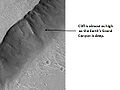
Cliff in Mare Acidalium, as seen by HiRISE. The location is 32.2 degrees north latitude and 54 degrees west longitude. Image was taken by the Mars Reconnaissance Orbiter's HiRISE. The HiRISE camera was built by Ball Aerospace and Technology orporation and is operated by the University of Arizona. Image courtesy NASA/JPL/University of Arizona.

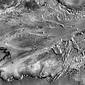
View of a portion of the Kasei Valles system of outflow channels in the region immediately southwest of the 100 km diameter martian crater Sharonov (partly visible at upper right). In this area of Kasei Valles there are three putative cataracts (dry falls) created by the megafloods that formed the channels.
This scene is a section of a larger THEMIS daytime infrared image mosaic of Kasei Valles. Kasei Valles is situated north of the Valles Marineris canyon system and drains eastward into Chryse Planitia. North is at the top.

Autor: European Space Agency, Licence: CC BY-SA 3.0 igo
This mosaic, which features the spectacular Kasei Valles, comprises 67 images taken with the High Resolution Stereo Camera on ESA’s Mars Express. The mosaic spans 987 km north–south (19–36°N) and 1550 km east–west (280–310°E).
Credit: ESA/DLR/FU Berlin (G. Neukum), CC BY-SA 3.0 IGO
Copyright Notice:
This work is licenced under the Creative Commons Attribution-ShareAlike 3.0 IGO (CC BY-SA 3.0 IGO) licence. The user is allowed to reproduce, distribute, adapt, translate and publicly perform this publication, without explicit permission, provided that the content is accompanied by an acknowledgement that the source is credited as 'ESA/DLR/FU Berlin’, a direct link to the licence text is provided and that it is clearly indicated if changes were made to the original content. Adaptation/translation/derivatives must be distributed under the same licence terms as this publication. To view a copy of this license, please visit creativecommons.org/licenses/by-sa/3.0/igo/
Rolling boulders in Kasei Valles. The location is 32.2 degrees north latitude and 54 degrees west longitude. Picture was taken with the Mars Reconnaissance Orbiter's HiRISE. Picture credit is NASA/JPL/ University of Arizona.