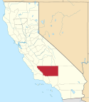
Kern County
| Kern County | |
|---|---|
 | |
| Geografie | |
| Hlavní město | Bakersfield |
| Status | okres |
| Souřadnice | 35°20′24″ s. š., 118°43′12″ z. d. |
| Rozloha | 21 138 km² |
| Časové pásmo | UTC-8/-7 |
| Geodata (OSM) | OSM, WMF |
| Obyvatelstvo | |
| Počet obyvatel | 839 631 (2010) |
| Hustota zalidnění | 39,7 obyv./km² |
| Správa regionu | |
| Nadřazený celek | Kalifornie |
| Vznik | 1866 |
| Oficiální web | www |
| Některá data mohou pocházet z datové položky. | |
Kern County je okres ve státě Kalifornie v USA. K roku 2010 zde žilo 839 631 obyvatel.[1] Správním městem okresu je Bakersfield. Celková rozloha okresu činí 21 138 km².
Sousední okresy
 | Monterey County a Kings County | Tulare County | Inyo County |  |
| San Luis Obispo County | San Bernardino County | |||
| Santa Barbara County | Los Angeles County a Ventura County |
Reference
- ↑ Archivovaná kopie. quickfacts.census.gov [online]. [cit. 2012-01-21]. Dostupné v archivu pořízeném dne 2011-07-13.
Externí odkazy
 Obrázky, zvuky či videa k tématu Kern County na Wikimedia Commons
Média použitá na této stránce
A stylized arrow pointing north.
A stylized arrow pointing west.
A stylized arrow pointing east.
A stylized arrow pointing south.
Flag of California. This version is designed to accurately depict the standard print of the bear as well as adhere to the official flag code regarding the size, position and proportion of the bear, the colors of the flag, and the position and size of the star.
Autor: John Wiley User:Jw4nvc - Santa Barbara, California, Licence: CC BY 3.0
Aerial: Portion of Tehachapi wind farms
Locator map showing Kern County — in central and southern California.


