Korutanské vévodství
| Korutanské vévodství Herzogtum Kärnten Vojvodina Koroška
| |||||||||||
Geografie
| |||||||||||
| Obyvatelstvo | |||||||||||
jihobavorská němčina, karantánština | |||||||||||
| Státní útvar | |||||||||||
dědičná monarchie | |||||||||||
| Státní útvary a území | |||||||||||
| |||||||||||
Vévodství korutanské (německy Herzogtum Kärnten, slovinsky Vojvodina Koroška) bylo vévodství na území, které se dnes nachází v jižní části Rakouska a na severu Slovinska. Zprvu bylo státem Svaté říše římské, později patřilo k Habsburské monarchii, bylo korunní zemí Rakouska a nakonec Rakouska-Uherska.
Historie

Oddělilo se roku 976 od Bavorského vévodství jako první nově vytvořený říšský stát po původních německých vévodstvích (bavorského, lotrinského, franckého, saského a švábského).


Korutany byly až do jejího zrušení roku 1806 součástí Svaté říše římské, ale od roku 1335 byly řízeny Habsburky v rámci jejich rakouských držav. V Rakousku resp. Rakousko-Uhersku také zůstaly jako jedna z korunních zemí až do rozpadu monarchie roku 1918.
Na základě korutanského plebiscitu roku 1920 pak hlavní část bývalého vévodství vytvořila rakouskou spolkovou zemi Korutany.
Externí odkazy
 Obrázky, zvuky či videa k tématu Korutanské vévodství na Wikimedia Commons
Média použitá na této stránce
Autor: F l a n k e r, Licence: CC BY-SA 2.5
Při zobrazení tohoto souboru lze snadno přidat orámování
Autor: David Liuzzo, eagle by N3MO, Licence: CC BY-SA 3.0
Banner of the Holy Roman Empire, double headed eagle with halos (1400-1806)
Autor: Sir Iain, eagle by N3MO, Licence: CC BY-SA 3.0
Banner of the Holy Roman Empire, with the arms of Austria.
House colours of the House of Habsburg
Autor: Dragovit (of the collage), Licence: CC BY-SA 4.0
Both national flags of Austro-Hungary, the collage of flags of the Cisleithania (Habsburg Monarchy) and the Transleithania (Kingdom of Hungary)
Autor: Ludovic Lepeltier-Kutasi, Licence: CC BY-SA 4.0
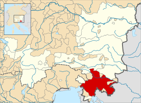
Map of the Duchy of Carinthia (red) within Cisleithania (white) and Austria-Hungary, circa 1914.
(c) MostEpic, CC BY-SA 4.0
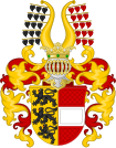
Coat of arms of the Duchy of Carinthia
Die Provinz Innerösterreich oder die Herzogthümer Steyermark, Kärnten, Krain, die Grafschaften Görz und Gradisca und das deutsch-österreichische Litorale
Všeslovanská vlajka shválena na všeslovanské konvenci v Praze v roku 1848
Autor: Alphathon /ˈæɫfə.θɒn/ (talk), Licence: CC BY-SA 4.0
A map of the Duchy of Carniola (German: Herzogtum Krain) at the time of the Hohenstaufen Emperors (circa 1250).
The highlighted area roughly corresponds with the later Austrian Circle. This has no meaning at the time shown and is used only to provide context.
Note that while it uses the same scheme as standard location/locator maps, this map technically does not conform to the standard, as it is not in equirectangular projection. Therefore grid lines for latitude and longitude are also included on the sub-map.Autor: SirFranzPaul, Licence: CC0
Stari grb Koroške (do 1269)
Flag of Hungary, from 6 November 1915 to 29 November 1918 and from August 1919 until mid/late 1946.
Autor: Theodore Christopher, Licence: CC BY-SA 4.0
A flag made up of a red and white stripe
Autor: Gb89.2, Licence: CC BY-SA 4.0
Banner of the Carolingian dynasty according to the Osprey Men at Arms, The Age of Charlemagne illustration of artist Angus McBride.
Autor:
The Austro-Hungarian Monarchy in 1914.

