Lút
| poušť Lút | |
|---|---|
| Světové dědictví UNESCO | |
 | |
| Smluvní stát | |
| Souřadnice | 30°15′50″ s. š., 59°14′28″ v. d. |
| Typ | přírodní dědictví |
| Kritérium | vii, viii |
| Odkaz | 1505 (anglicky) |
| Zařazení do seznamu | |
| Zařazení | 2016 (40. zasedání) |
Lút (persky دشت لوت – přepsáno Dašt-e Lút) je solná poušť ležící na území východního Íránu, zejména provincií Chorásán a Kermán. Na západě je ohraničena Kohrúdskými horami, součástí Íránské vysočiny. Na severu přechází v Dašt-e Kavír (Velkou solnou poušť). Na východě ji ohraničují pohoří podél afghánské hranice, např. Ešger (2856 m), Bálán (2712 m) a Palangán (2488 m).
Zaujímá území o rozloze 50 000 km², přičemž 9000 km² zabírá písečná poušť. Svojí rozlohou je 25. největší pouští na světě. Tvoří bezodtoké aridní území, na němž najdeme hlinitou a štěrkovou poušť. V jihovýchodní oblasti tvoří také duny. Část pouště (22 780 km²) byla v roce 2016 prohlášena světovým přírodním dědictvím pod ochranou UNESCO.
V letech 2005 a 2006 zde byla naměřena nejvyšší povrchová teplota (neplést s teplotou vzduchu) na Zemi (70,7 °C).[1]
Fotogalerie
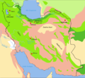
mapa Íránu s vyznačením pouště

satelitní snímek

pohled na část pouště

zdejší krajina

zdejší krajina

Reference
- ↑ Where Is the Hottest Place on Earth? [online]. NASA Earth Observatory [cit. 2016-10-20]. Dostupné online. (anglicky)
Externí odkazy
 Obrázky, zvuky či videa k tématu Lút na Wikimedia Commons
Média použitá na této stránce

Flag of Iran. The tricolor flag was introduced in 1906, but after the Islamic Revolution of 1979 the Arabic words 'Allahu akbar' ('God is great'), written in the Kufic script of the Qur'an and repeated 22 times, were added to the red and green strips where they border the white central strip and in the middle is the emblem of Iran (which is a stylized Persian alphabet of the Arabic word Allah ("God")).
The official ISIRI standard (translation at FotW) gives two slightly different methods of construction for the flag: a compass-and-straightedge construction used for File:Flag of Iran (official).svg, and a "simplified" construction sheet with rational numbers used for this file.
.svg)

.jpg)
Autor: yeowatzup, Licence: CC BY 2.0
Kaluts (yardangs), Dasht-e Lut, Iran

Pale tan dust billows over the Dasht-e Lut in eastern Iran, in this photo-like image from the Moderate Resolution Imaging Spectroradiometer (MODIS) on NASA’s Terra satellite. In the thickest part of the storm, the dust cloud blurs the texture of the land beneath it, revealing instead the texture of the air in waves and lines. The most distinctive waves surround Kuh-e Bazman, a 3,489-meter (11,450-foot) tall volcano, which rises above the dust cloud. The ripples in the dust are a reflection of turbulence created as air flows around the peak. The dust seeps into the valleys of the mountains south and east of the volcano. The Dasht-e Lut, is a large salt desert in remote eastern Iran. The dust storm blows across the southern desert, leaving clear the distinctive orange dune fields and wind-swept lines in the north.
Autor: Hadi Karimi هادی کریمی, Licence: CC BY-SA 3.0
کلوتهای شهداد در بیابان لوت

Autor: Fabienkhan, Licence: CC BY-SA 2.5
Simplified/improved version of Image:Iran biotopes.png, in french