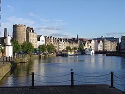
Leith
| Leith | |
|---|---|
 | |
| Poloha | |
| Souřadnice | 55°58′26″ s. š., 3°9′58″ z. d. |
| Nadmořská výška | 15 m n. m. |
| Časové pásmo | 0 |
| Stát | |
| Země | |
| Město | Edinburgh |
(c) Karte: NordNordWest, Lizenz: Creative Commons by-sa-3.0 de Leith | |
| Rozloha a obyvatelstvo | |
| Počet obyvatel | 50 000 (2011) |
| Správa | |
| Vznik | 1128 |
| Telefonní předvolba | 0131 |
| PSČ | EH6 |
| Některá data mohou pocházet z datové položky. | |
Leith [li:θ], gaelsky Lìte, je přístavní čtvrť města Edinburghu ve Skotsku. Nachází se severně od centra, při ústí řeky Water of Leith do zálivu Firth of Forth v Severním moři. Coby hlavní námořní přístav skotské metropole má Leith významné místo ve skotských dějinách.
Poprvé je zmiňován roku 1128 jako Inverlet (čili Inverleith, tedy vlastně „ústí Leithu“). Po staletí byl pod správnou Edinburghu, roku 1833 byl vyčleněn jako samostatná obec a roku 1920 opět připojen k Edinburghu. Od roku 2007 tvoří jeden z jeho 17 městských obvodů.
Díky dopravně výhodné poloze se zde vyvinulo středisko skotského průmyslu, jmenovitě sklářství, mydlářství, skladování lihovin, zpracování olova, rafinování cukru, obecně obchodu a přirozeně také rybářství, velrybářství a loďařství. Během 20. století došlo k úpadku řady těchto odvětví a Leith postihla chudoba a vystěhovalectví. Od konce 80. let dochází postupně k revitalizaci, také díky plánovitému rozvoji ze strany města i skotské vlády.
Odraz v kultuře
Do Leithu 80. let je zasazen román Trainspotting od Irvina Welshe.
Galerie
- Celkový pohled na Leith a záliv Firth of Forth
- (c) kim traynor, CC BY-SA 2.0Lamb's House
- Zbytky citadely
- Policejní stanice, bývalá radnice
- (c) kim traynor, CC BY-SA 2.0Hotel Malmaison
- (c) South Leith Parish Kirk by kim traynor, CC BY-SA 2.0Farní kostel pro jižní Leith
- Tzv. „Banánové byty“
- Val „Giant's Brae“
Reference
V tomto článku byl použit překlad textu z článku Leith na anglické Wikipedii.
Externí odkazy
 Obrázky, zvuky či videa k tématu Leith na Wikimedia Commons
Média použitá na této stránce
Autor: Kim Traynor, Licence: CC BY-SA 3.0
This tranced gateway (with some reconstruction on the left) is all that remains of Cromwell's fort at Leith. In 1656, Edinburgh was given the choice between paying for the building of this fort to control the trade of Leith or losing its jurisdiction over the port. The council advanced 60,000 pounds Scots towards its cost. When, after the Restoration, it became the property of the earl of Lauderdale, who threatened to create his own burgh of barony on this part of Leith, the council (i.e. of Edinburgh) had to pay the same amount, £5,000 sterling, to re-purchase the land.
(c) South Leith Parish Kirk by kim traynor, CC BY-SA 2.0
South Leith Parish Kirk
(c) kim traynor, CC BY-SA 2.0
Malmaison Hotel, The Shore Former seamen's mission, built in 1883 and converted to a hotel in 1994.
Autor: RuthAS, Licence: CC BY 3.0
Leith (centre), Edinburgh, Firth of Forth, Fife looking northwest.
Autor: Kim Traynor, Licence: CC BY-SA 3.0
Originally built as Leith Town Hall in 1827.
(c) Guinnog from en.wikipedia.org, CC BY-SA 3.0
Taken and donated by user:Guinnog
Autor: Kim Traynor, Licence: CC BY 3.0
Mound on Leith Links. It appears on the OS map as 'Somerset's Battery' and is known locally as 'Giant's Brae'.
(c) Karte: NordNordWest, Lizenz: Creative Commons by-sa-3.0 de
Location map of the United Kingdom
(c) kim traynor, CC BY-SA 2.0
A late 16thC or early 17thC merchant's house, used latterly as a Day Centre for the Elderly. Tradition has it that Mary, Queen of Scots, on landing in Leith in 1561, was received into the house of Andrew Lamb where she was entertained "for ane houre" while Holyrood Palace was being prepared for her reception. As this building dates from later than her arrival, it has been conjectured that Lamb had an earlier residence on or near the site. In 2011-12 it was renovated as a house and office by an architects' partnership.


