Letronne (kráter)
| Kráter Letronne | |
|---|---|
 Snímek kráteru Letronne při pohledu z Apolla 16. | |
| Souřadnice na Měsíci | |
| Selenografická šířka | 10,6° J |
| Selenografická délka | 42,4° Z |
| Další údaje | |
| Průměr kráteru | 118 km [1] |
| Hloubka | 1 km |
| Colongitudo | 42° |
| Eponym | Jean Antoine Letronne |
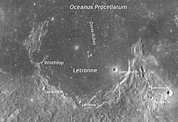
Letronne je lávou zaplněný pozůstatek impaktního kráteru na Měsíci nacházející se v oblasti Oceanus Procellarum. Pojmenován je podle francouzského archeologa Jeana Antoine Letronna.[1] Severní část kráteru je zakryta lávou úplně. Jihovýchodně od tohoto kráteru leží kráter Gassendi, severo-severozápadně kráter Flamsteed a západo-jihozápadně také lávou zalitý kráter Billy. Ve středu kráteru je malý shluk svahů, jinak je vnitřní část kráteru téměř hladká. Na západním okrajovém valu se nachází kráter Winthrop.
Satelitní krátery

V tabulce jsou krátery, které souvisí s kráterem Letronne.
| Letronne | Sel. šířka | Sel. délka | Průměr |
|---|---|---|---|
| A | 12.1° J | 39.1° Z | 7 km |
| B | 11.2° J | 41.2° Z | 5 km |
| C | 10.7° J | 38.5° Z | 4 km |
| F | 9.2° J | 46.1° Z | 8 km |
| G | 12.7° J | 46.5° Z | 10 km |
| H | 12.6° J | 46.0° Z | 4 km |
| K | 14.5° J | 43.6° Z | 5 km |
| L | 14.3° J | 44.3° Z | 5 km |
| M | 12.0° J | 44.1° Z | 3 km |
| N | 12.3° J | 39.8° Z | 4 km |
| T | 12.5° J | 42.6° Z | 3 km |
Dva satelitní krátery ke kráteru Letrone byly Mezinárodní astronomickou unií přejmenovány. Jsou to:
Odkazy
Reference
- ↑ a b Crater Letronne on Moon Gazetteer of Planetary Nomenclature, IAU, USGS (anglicky)
Externí odkazy
 Obrázky, zvuky či videa k tématu Letronne na Wikimedia Commons
 - (anglicky) Letronne Archivováno 30. 5. 2018 na Wayback Machine.
Média použitá na této stránce
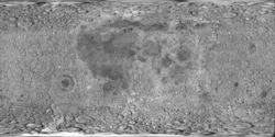
cylindrical map projection of the Moon. The Moon's whole surface was mapped by the Clementine spacecraft in 1994, here North is at the top. The dark floor of crater Plato is at the middle top above Mare Imbrium, while the bright floor and rays of crater Tycho is near the middle bottom below Mare Imbrium. Mare Procellarum is at the near left, and Mare Tranquillitatis is just right of centre and Mare Crisium is at the near right. The far left and far right show the contrast of the mostly cratered farside with small isolated mare.
The flooded remnant of Letronne crater on the Moon can be seen in this image taken during the Apollo 16 mission. This photo was used in Figure 182 of Apollo Over the Moon: A View from Orbit (NASA SP-362, 1978), which has the following caption:
- This arcuate structure is Letronne. It straddles the boundary between southern Oceanus Procellarum and the southern highlands. From "horn to horn" it is about 115 km wide. Astronomers have long recognized Letronne as a crater and geologists also interpret it as a crater because those parts preserved have much in common with better-preserved craters. The preserved crater elements include a large segment of a raised rim, a partly preserved blanket of ejecta occupying depressions along the lower edge of the picture, and the tips of three centrally located peaks that presumably represent the top of a buried central peak complex. The largest and steepest slopes along the rim face inward and probably define the wall of Letronne. The northern one-third of the rim and wall has been almost completely buried by the mare lavas of Oceanus Procellarum. An isolated small hill (arrow) and the crudely arcuate band of mare ridges east of the hill mark the approximate position of the buried rim. The abrupt disappearance of the rim beneath Oceanus Procellarum suggests faulting, but vertical movement without faulting is also possible; this part of Procellarum may have been tilted downward or the adjacent highlands upward.-G.W.C.
Photographic data:
- Image Name: AS16-M-2995
- Mission: Apollo 16
- Revolution (Orbit): 63
- Camera: Mapping/Metric
- Exposure: 00:00:00.0889
- Camera Tilt: VERT
- Scan Pixel Scale: 8.198
- Start Time: (DOY:115) 1972-04-24T23:30:11
- Spacecraft Altitude: 122.43 km
- Center Coordinates (lat, lon): -10.15°,-42.71°
- Corner Coordinates: -6.85°,-45.72°
- -7.2°,-39.33°
- -13.61°,-39.61°
- -13.21°,-46.2°
- Sun Elevation: 4.0°
- Features: FLAMSTEED A, LETRONNE, LETRONNE P
- Film Type: 3400
- Color: black&white
Craters Letronne and Winthrop (detail of LRO - WAC global moon mosaic; Mercator projection)


