Linie aktuální kontroly

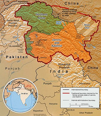
Linie aktuální kontroly (anglicky Line of Actual Control, ve zkratce LAC) je de facto hranicí mezi Čínskou lidovou republikou a Indií. Odděluje území, které je pod čínskou kontrolou, od území pod indickou kontrolou v těch místech, ve kterých neexistuje oboustranně uznaná hranice. Východně od Bhútánu se ve svém průběhu prakticky shoduje s McMahonovou linií.
Odkazy
Související články
- McMahonova linie
- Aksai Čin
- Čínsko-indická pohraniční válka
Externí odkazy
 Obrázky, zvuky či videa k tématu Linie aktuální kontroly na Wikimedia Commons
Média použitá na této stránce
Original text from CIA World Factbook: "The Disputed Territory : Shown in green is Kashmiri region under Pakistani control. The dark-brown region represents Indian-controlled Jammu and Kashmir while the Aksai Chin is under Chinese occupation."
Library of Congress, Geography and Map Division, Washington, D.C. 20540-4650 USA. Info from its archive page [1] for this map:
Kashmir region.
United States. Central Intelligence Agency.
CREATED/PUBLISHED [Washington : Central Intelligence Agency, 2003]
NOTES "763537AI (R00744) 5-03."
Relief shown by shading.
Shows boundaries and disputed areas.
Includes location map.
Scale [ca. 1:510,000].
SUBJECTS
- Jammu and Kashmir (India)--Maps
- Jammu and Kashmir (India)--Boundaries--Maps.
- India--Jammu and Kashmir.
MEDIUM 1 map : col. ; 20 x 17 cm.
CALL NUMBER G7653.J3 2003 .U51
REPOSITORY Library of Congress Geography and Map Division Washington, D.C. 20540-4650 USA
DIGITAL ID
g7653j ct001059 http://hdl.loc.gov/loc.gmd/g7653j.ct001059