Lunar Reconnaissance Orbiter
| Lunar Reconnaissance Orbiter | |
|---|---|
 | |
| COSPAR | 2009-031A |
| Start | 18. června 2009 21:32:00 UTC |
| Kosmodrom | Kennedyho vesmírné středisko Startovací komplex 41 |
| Nosná raketa | Atlas V |
| Typ oběžné dráhy | polární dráha |
| Stav objektu | Na oběžné dráze Měsíce |
| Zánik | Zánik |
| Zánik | ne |
| Provozovatel | NASA |
| Výrobce | NASA |
| Druh | měsíční sonda |
| Mateřské těleso | Měsíc |
| Hmotnost | 1846 kg |
| Délka | 2,62 m |
| Šířka | 2,74 m |
| Výška | 3,86 m |
| Parametry dráhy | |
| Apoapsida | 107 km |
| Periapsida | 73 km |
| Excentricita dráhy | 0,009 4 |
| Přístroje | |
| Nese přístroje | Cosmic Ray Telescope for the Effects of Radiation, Diviner Lunar Radiometer Experiment, Lyman-Alpha Mapping Project, Lunar Exploration Neutron Detector, Lunar Orbiter Laser Altimeter, Lunar Reconnaissance Orbiter Camera a Mini-RF |
| Oficiální web | Oficiální web |
| Některá data mohou pocházet z datové položky. | |
Lunar Reconnaissance Orbiter (LRO) je sonda, kterou americká agentura NASA vyslala v rámci programu Lunar Precursor Robotic Program na oběžnou dráhu kolem Měsíce. Start se konal 18. června 2009[1] a družici do kosmu vynesla raketa Atlas V. LRO je první misí splňující Vizi vesmírného průzkumu (Vision for Space Exploration) deklarovanou americkým prezidentem Georgem W. Bushem v roce 2004.
Záměrem mise je podporovat tuto vizi. Úkolem LRO je mapovat povrch Měsíce a hledat možná místa pro přistání lidské posádky – návrat lidí na Měsíc. Předběžná podoba byla dokončena v únoru 2006 a kritický design byl dokončen v listopadu 2006.
V srpnu 2014 rozhodla NASA o prodloužení mise sondy.[2]
Charakteristika
Hlavní úkoly mise:
- Globální topografie Měsíce
- Charakteristika vesmírné radiace na orbitě Měsíce
- Polární regiony včetně možných zásob vodního ledu a doby osvětlení
- Mapování při vysokém rozlišení (max 0,5 m), které pomůže v budoucnu vybrat místa pro pilotované přistání
Vývoj probíhal v laboratoři NASA, Goddardově kosmickém středisku. LRO krouží kolem Měsíce po polární dráze a délka hlavní mise měla původně čint jeden rok. Po ukončení hlavní mise měla LRO sloužit jako komunikační družice pro jiné pozemní mise na Měsíci, např. pozemní sondy nebo rovery podobné MER.
Přestože sonda je americká a její start provedla NASA, řídící středisko v Arizonské státní univerzitě má pod kontrolou nejen kameru, ale i interpretaci snímků, a je pod kontrolou mnoha akademických skupin,[3] z nichž některé sídlí mimo spojené státy a nejsou financované americkou vládou (například Německé středisko pro letectví a kosmonautiku).[4] Proto jsou fotografie z roku 2009, na kterých jsou vidět přistávací místa misí Apollo, části měsíčních modulů a vědeckých přístrojů zanechaných na povrchu Měsíce, dokonce i vyšlapané cestičky mezi nimi,[5] používány jako důkaz přistání člověka na Měsíci a k vyvracení konspiračních teorií o přistání Apolla na Měsíci.
Popis sondy

Sonda nese soubor šesti vědeckých přístrojů a jeden technologický experiment:
- CRaTER – prvotní cíl CRaTERu je charakterizovat globální lunární radiační prostředí a jeho biologické dopady.
- DLRE – měří termální emise měsíčního povrchu
- LAMP – pozoruje povrch měsíce v ultrafialovém pásmu, pátrat po zdrojích ledu.
- LEND – měření, vytváření map, detekce možné podpovrchové zásoby vody.
- LOLA – poskytuje přesný globální lunární topografický model a souřadnicovou síť, která bude sloužit k jeho pochopení.
- LROC – Lunar Reconnaissance Orbiter Camera
- Mini-RF – má demonstrovat nové lehké SAR a komunikační technologie, lokalizuje potenciální vodní led.
Mapování povrchu Měsíce ve vysokém rozlišení umožní spatřit některé větší kusy vybavení, které zde zůstaly od poslední výpravy na Měsíc.
Galerie
- Snímky z mise Lunar Reconnaissance Orbiter
 1. snímek LRO (30. června 2009)
 místo přistání Apolla 11
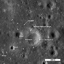 místo přistání Apolla 12 a Surveyoru 3
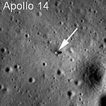 místo přistání Apolla 14
 místo přistání Apolla 15
 místo přistání Apolla 16
 místo přistání Apolla 17
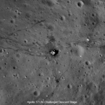 místo přistání Apolla 17
 místo přistání Surveyoru 1
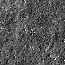 snímek sondy LADEE letící nad povrchem
- Měsíc

 severní pól
 jižní pól

Odkazy
Reference
- ↑ Lunar Reconnaissance Orbiter Launch [online]. [cit. 2009-06-18]. Dostupné v archivu pořízeném dne 2012-03-16.
- ↑ LEONE, Dan. Curiosity, Cassini Among 7 Extended Planetary Missions [online]. Spacenews.com [cit. 2014-09-01]. Dostupné v archivu pořízeném dne 2020-06-02. (anglicky)
- ↑ The LROC Team. www.lroc.asu.edu [online]. Arizona State University [cit. 2022-11-17]. Dostupné online.
- ↑ O nás. Institute of Space Systems [online]. German Aerospace Center [cit. 2022-11-17]. Dostupné online.
- ↑ Nové snímky Měsíce zachytily po desetiletích lidské stopy [online]. [cit. 2009-07-19]. Dostupné v archivu pořízeném dne 2009-07-20.
Související články
Externí odkazy
 Obrázky, zvuky či videa k tématu Lunar Reconnaissance Orbiter na Wikimedia Commons
 - (česky) Databáze kosmických sond
- (česky) LRO na mek.kosmo.cz
- (anglicky) LRO na stránkách NASA
- (anglicky) Zprávy o misi na webu NASA
Média použitá na této stránce

One of the first images produced by the Lunar Reconnaissance Orbiter. Regions near the moon's Mare Nubium region, as photographed by the Lunar Reconnaissance Orbiter's LROC instrument. The spacecraft transmitted its first images of the lunar surface captured with the LROC that were activated on 2009-06-30. The area that has been imaged is a few kilometers east of Hell E crater in the lunar highlands south of Mare Nubium. The images were taken on a terminator, the dividing line between day and night. Each image shows a region that is 1400 meters wide with features as small as 3 meters wide discerned.

LRO Sees Apollo 15 Landing Site

LROC Wide Angle Camera (WAC) mosaic of the lunar South Pole region, width ~600 km (372 miles). The lunar South Pole is one of the most compelling places in the entire Solar System. This region of the Moon is important for both lunar scientists and engineers planning future human exploration. The towering massifs of the South Pole-Aitken Basin can be accessed, and these massifs contain impact melt that will allow scientists to unambiguously determine the age of this huge basin. Furthermore, permanently shadowed craters may harbor reservoirs of ices and other volatile compounds that could serve as a tremendously valuable resource for future explorers. Additionally, these volatile deposits could contain a priceless record of water composition dating back to the beginning of our Solar System, an incomparable dataset for astrobiology investigations. Finally, a few mountain peaks near the pole (just west and east of the rim Shackleton crater) are illuminated for extended periods of time, providing the near-constant solar power that would be required for the economical operation of a permanent lunar outpost.
Tycho crater's central peak complex casts a long, dark shadow near local sunrise in this spectacular lunar-scape. The dramatic oblique view was recorded by the Lunar Reconnaissance Orbiter. The rugged complex is about 15 kilometres wide, formed in uplift by the giant impact that created the well-known ray crater 100 million years ago. The summit of its central peak reaches 2 kilometres above the Tycho crater floor.

LRO Sees Apollo 16 Landing Site

LRO Sees Apollo 14 Landing Site

Low periapsis Narrow Angle Camera image of the Apollo 17 Landing Site. Image is 150 meters wide, Sun from the left, north towards top
_01.png)
The Lunar Reconnaissance Orbiter (LRO) is the first mission in NASA's Vision for Space Exploration, a plan to return to the moon and then to travel to Mars and beyond. The LRO objectives are to finding safe landing sites, locate potential resources, characterize the radiation environment, and demonstrate new technology.
The spacecraft will be placed in low polar orbit (50 km) for a 1-year mission under NASA's Exploration Systems Mission Directorate. LRO will return global data, such as day-night temperature maps, a global geodetic grid, high resolution color imaging and the moon's UV albedo. However there is particular emphasis on the polar regions of the moon where continuous access to solar illumination may be possible and the prospect of water in the permanently shadowed regions at the poles may exist. Although the objectives of LRO are explorative in nature, the payload includes instruments with considerable heritage from previous planetary science missions, enabling transition, after one year, to a science phase under NASA's Science Mission Directorate.

LRO Sees Apollo 17 Landing Site
Lunar Reconnaissance Orbiter payload
.jpg)
LROC Wide Angle Camera mosaic of the Moon's north pole; polar stereographic projection, 60°N to 90°N.

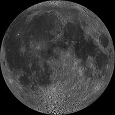
Near side of the moon, by NASA's Lunar Reconnaisance Orbiter. Orthographic projection centred at 0° longitude, 0° latitude.

Apollo 12 This image from LRO shows the spacecraft's first look at the Apollo 12 landing site. The Intrepid lunar module descent stage, experiment package (ALSEP) and Surveyor 3 spacecraft are all visible. Astronaut footpaths are marked with unlabeled arrows. This image is 824 meters (about 900 yards) wide. The top of the image faces North. Photo is taken by the artificial satellite Lunar Reconnaissance Orbiter in 2009

NASA's LRO Snaps a Picture of NASA's LADEE Spacecraft - With precise timing, the camera aboard NASA's Lunar Reconnaissance Orbiter (LRO) was able to take a picture of NASA's Lunar Atmosphere and Dust Environment Explorer (LADEE) spacecraft as it orbited our nearest celestial neighbor. The Lunar Reconnaissance Orbiter Camera (LROC) operations team worked with its LADEE and LRO operations counterparts to make the imaging possible.
LADEE is in an equatorial orbit (east-to-west) while LRO is in a polar orbit (south-to-north). The two spacecraft are occasionally very close and on Jan. 15, 2014, the two came within 5.6 miles (9 km) of each other. As LROC is a push-broom imager, it builds up an image one line at a time, so catching a target as small and fast as LADEE is tricky. Both spacecraft are orbiting the moon with velocities near 3,600 miles per hour (1,600 m/s), so timing and pointing of LRO must be nearly perfect to capture LADEE in an LROC image.
LADEE passed directly beneath the LRO orbit plane a few seconds before LRO crossed the LADEE orbit plane, meaning a straight down LROC image would have just missed LADEE. The LADEE and LRO teams worked out the solution: simply have LRO roll 34 degrees to the west so the LROC detector (one line) would be in the right place as LADEE passed beneath.
As planned at 8:11 p.m. EST on Jan. 14, 2014, LADEE entered LRO's Narrow Angle Camera (NAC) field of view for 1.35 milliseconds and a smeared image of LADEE was snapped. LADEE appears in four lines of the LROC image, and is distorted right-to-left.

Hi-res view of the Apollo 11 landing site from the Lunar Reconnaissance Orbiter. LROC M175124932R. Aside from the objects pointed out traces from moonwalk are seen.

Far side of the moon, by NASA's Lunar Reconnaissance Orbiter. Orthographic projection centred at 180° longitude, 0° latitude.
Because the moon is tidally locked (meaning the same side always faces Earth), it was not until 1959 that the farside was first imaged by the Soviet Luna 3 spacecraft (hence the Russian names for prominent farside features, such as Mare Moscoviense). And what a surprise – unlike the widespread maria on the nearside, basaltic volcanism was restricted to a relatively few, smaller regions on the farside, and the battered highlands crust dominated. A different world from what we saw from Earth.
Of course, the cause of the farside/nearside asymmetry is an interesting scientific question. Past studies have shown that the crust on the farside is thicker, likely making it more difficult for magmas to erupt on the surface, limiting the amount of farside mare basalts. Why is the farside crust thicker? That is still up for debate, and in fact several presentations at this week's Lunar and Planetary Science Conference attempt to answer this question.
The Clementine mission obtained beautiful mosaics with the sun high in the sky (low phase angles), but did not have the opportunity to observe the farside at sun angles favorable for seeing surface topography. This WAC mosaic provides the most complete look at the morphology of the farside to date and will provide a valuable resource for the scientific community. And it's simply a spectacular sight!
The Lunar Reconnaissance Orbiter Camera (LROC) Wide Angle Camera (WAC) is a push-frame camera that captures seven color bands (321, 360, 415, 566, 604, 643, and 689 nm) with a 57 km swath (105 km swath in monochrome mode) from a 50 km orbit. One of the primary objectives of LROC is to provide a global 100 m/px monochrome (643 nm) base map with incidence angles between 55° and 70° at the equator, lighting that is favorable for morphological interpretations. Each month, the WAC provides nearly complete coverage of the Moon under unique lighting. As an added bonus, the orbit-to-orbit image overlap provides stereo coverage. Reducing all these stereo images into a global topographic map is a big job, which is being led by LROC Team Members from the German Aerospace Center (Deutsches Zentrum für Luft- und Raumfahrt; DLR). Several preliminary WAC topographic products have appeared in LROC featured images over the past year (Orientale basin, Sinus Iridum). The WAC topographic dataset will be completed and released later this year.
The global mosaic released today is comprised of over 15,000 WAC images acquired between November 2009 and February 2011. The non-polar images were map-projected onto the GLD100 shape model (WAC derived 100 m/px DTM), while polar images were map-projected on the LOLA shape model. In addition, the LOLA-derived crossover-corrected ephemeris and an improved camera pointing provide accurate positioning (better than 100 m) of each WAC image.
Surveyor 1 photographed by the Lunar Reconnaissance Orbiter