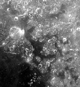
Mare Anguis


Mare Anguis (česky Moře hada nebo Hadí moře) je malé měsíční moře nepravidelného tvaru s plochou přibližně 10 000 km²[1] rozkládající se na severovýchodním okraji Mare Crisium (Moře nepokojů) na přivrácené straně Měsíce. Dominantu zde tvoří výrazný kráter Eimmart (průměr cca 46 km)[1] se sítí satelitních kráterů. Povrch moře je tmavý (stejně jako u většiny ostatních měsíčních moří), což indikuje, že moře bylo vyplněno vulkanickými bazalty.
Střední selenografické souřadnice Mare Anguis jsou 22,4° S, 67,6° V.[2]
Odkazy
Reference
V tomto článku byl použit překlad textu z článku Mare Anguis na anglické Wikipedii.
- ↑ a b RÜKL, Antonín. Atlas Měsíce. Praha: Aventinum, 1991. ISBN 80-85277-10-7. Kapitola Plutarch, s. 80/27.
- ↑ Mare Anguis, Gazetteer of Planetary Nomenclature, IAU, USGS, NASA (anglicky)
Literatura
- RÜKL, Antonín. Atlas Měsíce. Praha: Aventinum, 1991. ISBN 80-85277-10-7.
Související články
Externí odkazy
 Obrázky, zvuky či videa k tématu Mare Anguis na Wikimedia Commons
 - Mare Anguis, Gazetteer of Planetary Nomenclature, IAU, USGS, NASA (anglicky)
- Mare Anguis, NASA.gov (anglicky)
Média použitá na této stránce
en:Mare Anguis is in the middle of the picture. It is located on the near side of the moon (the side facing the Earth), and is about 150 miles in diameter. Located within the Crisium basin, Mare Anguis is a part of the Nectarian System, meaning that it was formed during the Nectarian time period (according to Wilhelms, 1987 (Plate 9A) - Upper Imbrian epoch). Like most maria, the surface of Mare Anguis is dark, indicating that it has been filled with volcanic basalt. The crater at the left center is Eimmart, at the northwestern tip of Mare Anguis. The dark patch in the lower left corner is the northeastern edge of Mare Crisium.
Mare Anguis with crater Eimmart (detail of LROC - WAC global moon mosaic)
Autor: User:Silvercat, Licence: CC BY-SA 3.0
The Location of Mare Anguis, One of the Lunar Geographical Features.


