Menhiry de la Fage
| Menhiry de la Fage | |
|---|---|
 | |
| Poloha | |
| Adresa | Les Bondons, |
| Souřadnice | 44°24′50,76″ s. š., 3°35′43,62″ v. d. |
| Další informace | |
| Kód památky | PA00103796 a PA00103797 |
| Některá data mohou pocházet z datové položky. | |
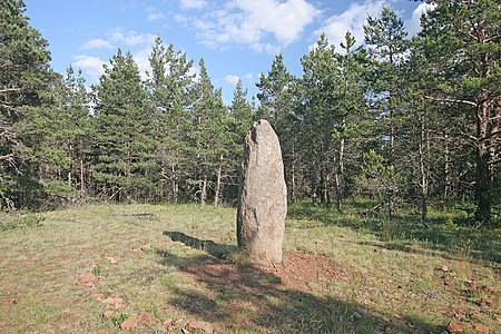
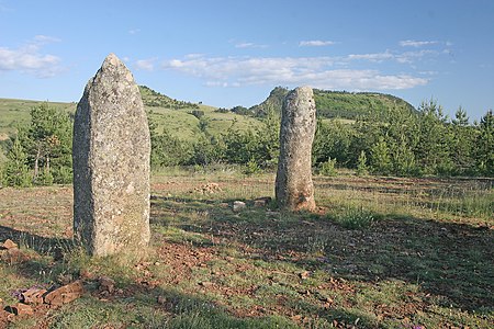
Menhiry de la Fage jsou skupinou asi 40 menhirů v okolí samoty Les Combettes v oblasti Cham des Bondons. Jednotlivé menhiry se nalézají ve dvou větších skupinách, západní skupina je tvořena kameny o výšce max. 2 m a umístěnými převážně v borovicovém lese, východní skupinu tvoří vyšší kameny, některé až přes 3 m nalézající se většinou na volném prostranství.
Menhiry této skupiny jsou propojeny naučnou stezkou vedoucí po okruhu o délce 5 km s převýšením 175 m, kterou lze projít asi za dvě hodiny. Naučná stezka má celkem 10 zastavení.
Fotogalerie

Menhiry de la Fage

Menhiry de la Fage
Menhiry de la Fage

Menhiry de la Fage
Menhiry de la Fage

Menhiry de la Fage
Externí odkazy
 Obrázky, zvuky či videa k tématu Menhiry de la Fage na Wikimedia Commons
Média použitá na této stránce


Menhirs de la Fage 18.JPG
Autor: Petr1888, Licence: CC BY-SA 3.0
Menhirs de la Fage
Autor: Petr1888, Licence: CC BY-SA 3.0
Menhirs de la Fage
|
This building is indexed in the base Mérimée, a database of architectural heritage maintained by the French Ministry of Culture, under the reference PA00103797
|
| Pozice fotografa | | Tento snímek a mnohé další na: OpenStreetMap |
|---|

Menhirs de la Fage 14.JPG
Autor: Petr1888, Licence: CC BY-SA 3.0
Menhirs de la Fage
Autor: Petr1888, Licence: CC BY-SA 3.0
Menhirs de la Fage
|
This building is indexed in the base Mérimée, a database of architectural heritage maintained by the French Ministry of Culture, under the reference PA00103797
|
| Pozice fotografa | | Tento snímek a mnohé další na: OpenStreetMap |
|---|

Cham des Bondons Pierre des trois paroisses.jpg
(c) Photo: Myrabella / Wikimedia Commons, CC BY-SA 3.0
This building is inscrit au titre des monuments historiques de la France. It is indexed in the base Mérimée, a database of architectural heritage maintained by the French Ministry of Culture, under the reference PA00103796 .
.
(c) Photo: Myrabella / Wikimedia Commons, CC BY-SA 3.0
This building is inscrit au titre des monuments historiques de la France. It is indexed in the base Mérimée, a database of architectural heritage maintained by the French Ministry of Culture, under the reference PA00103796

Menhirs de la Fage 03.JPG
Autor: Petr1888, Licence: CC BY-SA 3.0
Menhirs de la Fage
Autor: Petr1888, Licence: CC BY-SA 3.0
Menhirs de la Fage
|
This building is indexed in the base Mérimée, a database of architectural heritage maintained by the French Ministry of Culture, under the reference PA00103796
|
| Pozice fotografa | | Tento snímek a mnohé další na: OpenStreetMap |
|---|
Cham des Bondons Chabusse.jpg
Autor: Myrabella, Licence: CC BY-SA 3.0
This building is inscrit au titre des monuments historiques de la France. It is indexed in the base Mérimée, a database of architectural heritage maintained by the French Ministry of Culture, under the reference PA00103797.
Autor: Myrabella, Licence: CC BY-SA 3.0
This building is inscrit au titre des monuments historiques de la France. It is indexed in the base Mérimée, a database of architectural heritage maintained by the French Ministry of Culture, under the reference PA00103797

Menhirs de la Fage 09.JPG
Autor: Petr1888, Licence: CC BY-SA 3.0
Menhirs de la Fage
Autor: Petr1888, Licence: CC BY-SA 3.0
Menhirs de la Fage
|
This building is indexed in the base Mérimée, a database of architectural heritage maintained by the French Ministry of Culture, under the reference PA00103796
|
| Pozice fotografa | | Tento snímek a mnohé další na: OpenStreetMap |
|---|
