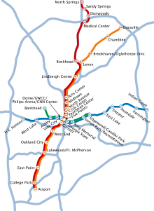
Metro v Atlantě


Metro v Atlantě (anglicky: Metropolitan Atlanta Rapid Transit Authority, zkratka MARTA) je systém metra obsluhující město Atlanta v USA (stát Georgie). Bylo otevřeno 30. června 1979, má 4 linky (které jsou ale na mnoha úsecích souběžné), má 38 stanic a jeho celková délka je 77 kilometrů. Pod systém MARTA se též řadí mnoho linek autobusů, které v Atlantě jezdí.


Linky metra v Atlantě
| Barva | Otevření | Počet stanic |
|---|---|---|
| █ Zlatá | 1991 | 18 |
| █ Červená | 1991 | 19 |
| █ Modrá | 1979 | 15 |
| █ Zelená | 1992 | 9 |
Zlatá linka
Zlatá linka má 18 stanic. Stanice zlaté linky:
- Airport
- College Park
- East Point
- Lakewood/Ft.McPherson
- Oakland City
- West End
- Garnett
- Five Points
- Peachtree Center
- Civic Center
- North Avenue
- Midtown
- Arts Center
- Lindbergh Center
- Lenox
- Brookhaven/Oglethorpe
- Chamblee
- Doraville
Červená linka
Červená linka má 19 stanic. Stanice červené linky:
- Airport
- College Park
- East Point
- Lakewood/Ft.McPherson
- Oakland City
- West End
- Garnett
- Five Points
- Peachtree Center
- Civic Center
- North Avenue
- Midtown
- Arts Center
- Lindbergh Center
- Buckhead
- Medical Center
- Dunwoody
- Sandy Springs
- North Springs
Modrá linka
Modrá linka má 15 stanic. Stanice modré linky:
- Indian Creek
- Kensington
- Avondale
- Decatur
- East Lake
- Edgewood/Candler Park
- Inman Park/Reynoldstown
- King Memorial
- Georgia State
- Five Points
- Dome/GWCC/Philips Arena/CNN Center
- Vine City
- Ashby
- West Lake
- Hamiltong E.Holmes
Zelená linka
Zelená linka má 9 stanic. Stanice zelené linky:
- Edgewood/Candler Park
- Inman Park/Reynoldstown
- King Memorial
- Georgia State
- Five Points
- Dome/GWCC/Philips Arena/CNN Center
- Vine City
- Ashby
- Bankhead
Reference
V tomto článku byl použit překlad textu z článku Metro de Atlanta na španělské Wikipedii.
Externí odkazy
 Obrázky, zvuky či videa k tématu Metro v Atlantě na Wikimedia Commons
Média použitá na této stránce
Autor: No machine-readable author provided. Earlopogous assumed (based on copyright claims)., Licence: CC BY-SA 2.5
Autor: Mx. Granger, Licence: CC0
Dome / GWCC / Philips Arena / CNN Center station in Atlanta.
(c) [[:en:User:DeKalb|DeKalb]] from en.wikipedia.org, CC BY-SA 3.0
MARTA's Airport Station at the South Airport Terminal of Hartsfield–Jackson Atlanta International Airport, in Atlanta, Georgia, USA.
(c) Fjdollars2010 na projektu Wikipedie v jazyce angličtina, CC BY-SA 3.0
Southbound MARTA train at Civic Center Station, Atlanta, Georgia
Autor: James Willamor, Licence: CC BY-SA 2.0
Dunwoody MARTA station
Platform level, Sandy Springs MARTA Station, Sandy Springs, Georgia, U.S.A.
Map of the Metropolitan Atlanta Rapid Transit Authority's rail system. Light blue lines represent major interstate and state highways. Rail lines are orange (North/South) and dark blue (East/West). White circles represent the locations of train stations.
self-taken image of MARTA's lenox station


