Národní park Morne Trois Pitons
| Národní park Morne Trois Pitons | |
|---|---|
| Světové dědictví UNESCO | |
 | |
| Smluvní stát | |
| Souřadnice | 15°16′ s. š., 61°17′ z. d. |
| Typ | přírodní dědictví |
| Kritérium | viii, x |
| Odkaz | 814 (anglicky) |
| Oblast | Latinská Amerika a Karibik |
| Zařazení do seznamu | |
| Zařazení | 1997 (21. zasedání) |
Morne Trois Pitons je jedním ze 3 národních parků v karibském státě Dominika. Území bylo vyhlášeno národním parkem v roce 1975 a později (rok 1997) byl tento park zapsán na seznam Světového přírodního dědictví UNESCO. Park se rozkládá kolem stejnojmenné hory Morne Trois Pitons (1 342 m n. m.) a zaujímá plochu 6857 ha, což představuje 9,1% rozlohy celého státu. Většinu území pokrývá původní tropický prales typický pro Malé Antily. Projevuje se zde i vulkanická aktivita - nacházejí se zde např. menší gejzíry a fumaroly.
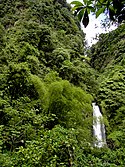
- © Hans Hillewaert, CC BY-SA 3.0
Trafalgar Falls
Externí odkazy
 Obrázky, zvuky či videa k tématu Národní park Morne Trois Pitons na Wikimedia Commons
 - Morne Trois Pitons National park, Commonwealth of Dominica [online]. United Nation Environment Programme [cit. 2021-05-05]. Dostupné online. (anglicky)
Média použitá na této stránce
Freshwater Lake (L'Etang) lies in the moat between Micotrin lava dome and the eastern wall of the Wotten Waven caldera, partially visible in the background. The 7 x 4.5 x wide caldera is elongated in an SW-NE direction, and it extends on the SW to near the capital city of Roseau. The two coalesced lava domes of Micotrin straddle the NE rim of the caldera. Strong geothermal activity persists in the caldera, the most prominent of which lies near the village of Wotten Waven along the River Blanc and contains numerous bubbling pools and fumaroles.
© Hans Hillewaert, CC BY-SA 3.0
Rainforest at Trafalgar Falls, Dominica, W.I.
Valley of desolation in Morne Trois Pitons National Park
The Boiling Lake at the Valley of Desolation in Dominica


