Nabatejci

Nabatejci byli semitský arabský kmen pocházející od prvorozeného Izmaelova syna Nebajóta, který se usídlil ve 4. století př. n. l. na dřívějším území Edómu.[1]
| „ | Toto jsou jména Izmaelových synů, podle nichž jsou pojmenovány jejich rody: Izmaelův prvorozený Nebajót, Kédar, Adbeel a Mibsám. | “ |
| — Gn 25, 13 (Kral, ČEP) | ||
Historie
Starověký kmen Nabatejců vytvořil poměrně rozsáhlou říši, jejíž největší rozkvět nastal v letech 85–62 př. n. l., a jež sahala na jihu asi po Teimân, na severu až po Damašek a na západě k Rudému moři.[1] Nabatejci byli pastevecký lid s hojnými stády velbloudů a ovcí, jenž byl však také svobodomyslný a bojovný. Zpočátku žili z loupežných výprav do sousedních zemí, přepadávali a loupili obchodní karavany a později sami rozvinuli výnosný obchod mezi Arábií a Indií. [1][2][3]
Ve spisech řeckého diplomata a historika Hieronyma z Cardie se roku 312 př. n. l. píše: „Východní provincie mezi Sýrií a Egyptem jsou obydleny Araby, kteří se nazývají Nabatejci. Žijí jako lupiči a dělají nájezdy na sousední země. Je těžké je vojensky zdolat, neboť žijí v bezvodé pustině, kopou cisterny, ale nikdo jiný neví, kde se tyto cisterny nacházejí.“[2]
Další písemná zmínka o Nabatejcích v Knize XIX „Biblioteca historica“ od Diodóra Sicilského (90–27 př. n. l.) uvádí žádost generálů (diadochů) Alexandra Velikého zaútočit v roce 315 př. n. l. na Petru.[1][4] Nabatejci také bojovali s Makabejci, s králi syrskými a z Římanů k nim pronikl Pompeius roku 63 př. n. l.[1]
Řím na přelomu letopočtu ovládal již skoro celý Blízký východ a Zajordánsko rozdělil do tří oblastí: severní Dekapolis zůstal nezávislým, centrální oblasti vládl Římany dosazený židovský král a jih zahrnoval nezávislé Nabatejské království s hlavním městem Petra.[5] Na severu v Sýrii na křižovatce karavanních cest se vzmáhalo nové obchodní centrum v poušti – Palmýra (arab.Tadmór), které kdysi dal vybudovat král Šalomoun. (1Kr 9, 18 (Kral, ČEP), 2Pa 8, 4 (Kral, ČEP)) Římané pak celé Zajordánsko, kromě Dekapole, zahrnuli do římské provincie Arabia s novým hlavním městem Bosra v Sýrii.[6]
Obchodníci
Nabatejci se stali úspěšnými obchodníky, kteří bohatli na monopolním obchodu s kadidlem a myrhou.[6] Nabyté znalosti mořských a karavanních cest Nabatejci využili k rozsáhlému obchodování také s kořením, parfémy, zvířaty, kovy (měď, železo), cukrem, slonovinou, perlami a bavlnou. Na Rudém moři byli však obávanými piráty. Těžili také minerály a z Mrtvého moře získávali asfalt, který vyváželi do Egypta, kde byl potřebný k balzamování zemřelých.[2]

Hlavní karavanní cesta dlouhá 2384 km spojovala jižní Arábii se středomořským přístavem Gaza. Bylo na ní 65 karavanních stanic s chrámem, jenž sloužil i jako banka, chovali se zde velbloudi, ovce a kozy; nacházely se tu cisterny s vodou, napajedla, lázně a hřbitovy. Na ochranu karavan byly kolem cesty rozloženy vojenské tábory a vystavěny strážní věže.[2]
Města
Slávu skalního města Petra pomohly založit objevené prameny vod, které umožnily vybudovat město uprostřed pouště na křižovatce starověkých obchodních cest. Město se skrylo v hradbě pískovcových skal, do nichž byly vytesány hrobky, chrámy a jiné budovy pro potřeby bohatých kupců.[7] Petra, někdejší edomské město Sela, (2Kr 14, 7 (Kral, ČEP), Iz 16, 1 (Kral, ČEP)) nabatejsky Reqem,[2] bylo zpočátku skladiště nakradeného zlata, drahých mastí, kadidla a dalšího zboží – jak uvádí první písemná zmínka o městě z roku 312 př. n. l..[3] Jako hlavní město Nabatejců se poté Petra stala sídlem králů, symbolem moci a bohatství.
Většina nabatejských měst ležících v Negevské poušti je zapsána na listinu Světového dědictví UNESCO: Šivta (Sobata), Avdat (Obodat), Elusa (Haluza) a Mamšit (Memphis).[3][2] Dalšími významnými městy byla Hegra (Madáin Sálih), rudomořský přístav Leuke Kome (Wadi Ainounah) na Kadidlové stezce a oáza Tayma v Saúdské Arábii.[2]
Králové
Královské Nabatejská dynastie si udržovala v uctivé vzdálenosti od sebe izraelské Hasmonejce i vládnoucí Římany ozbrojenými roztržkami, sňatky a placením tributu.[3] Matka židovského krále Heroda I. Velikého (Ukrutného) byla nabatejská princezna z Petry Cypros a jeho syn Héródes Antipas opustil svou ženu Phasaelis, dceru nabatejského krále Aretase IV. Philopatrise, aby žil s manželkou svého bratra Herodiadou. (Mk 6, 17–18 (Kral, ČEP)) Král Aretas IV. za to na něj vojensky vytáhl a zvítězil nad ním.[2] Dcera Herodiady Salome byla příčinou stětí hlavy svatého Jana Křtitele na hradě Machaerus.[2] Za vlády králů Aretase III. (87–62 př. n. l.) a Aretase IV. (9 př. n. l. – 40 n. l.), jenž měl přídomek „Přítel svého lidu“, Nabatejské království dosáhlo svého vrcholu a rozprostíralo se od Jemenu až po Damašek.[2][4]
| „ | Místodržitel krále Arety dal hlídat brány města Damašku, aby se mne zmocnil, byl jsem však v koši spuštěn otvorem v hradbách, a tak jsem unikl jeho rukám. | “ |
| — 2Kor 11, 32–33 (Kral, ČEP) | ||
Kultura a jazyk

Nabatejci jako jeden z arabských kmenů mluvili starou arabštinou a také řecky, písmo však používali aramejské. Aramejština se později stala lingua franca celého Středního východu.[2] Nabatejci domy nestavěli, žili ve stanech. Kamenné domy byly podle nich příbytky bohů a Nabatejci věřili, že když člověk nebude k ničemu připoután, bude svobodný.[2] V divadlech však pořádali řecká představení, fasády zdobili výjevy z mytologie nebo vyobrazením vládců města.[3] V nabatejských stavbách se odrážejí prvky helénské, egyptské i asyrské architektury jako výsledek zkušeností z obchodních styků s jinými kulturami.[4] Nejslavnější stavba v Petře pojmenovaná jako Pokladnice je pravděpodobně hrobkou krále Areta IV.[2]
V demokratické nabatejské kultuře byly ženy rovnoprávné s muži a ve společnosti i v politice hrály důležitou úlohu. Ženy vedly obchody, vlastnily půdu a měly stejné právo na dědictví jako muž.[2]
Náboženství
Nabatejci uctívali jako hlavního boha Dusárese a bohyni al-Uzza, kterým byli v Petře zasvěceni dva chrámy.[1][2] Nabatejci věřili v posmrtný život, proto do skal tesali hrobky.[2] Mnohé nabatejské chrámy se nacházejí také v Jordánsku v údolí Wádí Rum.[2]Jejich pohanský pantheon[8] postupně splynul s božstvy řeckými a římskými. Od 4. století n. l. se mnoho Nabatejců stalo křesťany, řecká křesťanská kultura se rychle rozšířila, stavěly se nové kostely a také některé nabatejské chrámy byly přestavěny na kostely.[4][6] Skalní město Petra se stalo sídlem biskupa.[2]
Úpadek
Římané během vojenského tažení roku 25 př. n. l. odhalili tajemství nabatejského bohatství a začali stavět lodě, které byly vhodné k plavbě po Rudém moři a po Indickém oceánu, kterými poté začali převážet parfémy, kadidlo a koření do Evropy přes jimi ovládaný Egypt. Nové námořní cesty byly levnější, ceny vzácného zboží klesly a nabatejské karavanní cesty ztratily svůj původní monopolní význam. Poslední nabatejský král vládl ze syrské Bosry a Nabatejské království bylo roku 106 n. l. pohlceno Římem za císaře Trajána jako provincie Arabia Petraea.[2][5] Skalní město Petra zasypala velká zemětřesení roku 363 a 551 a po muslimské invazi roku 636 město zpustlo a bylo zaváto všudypřítomným pískem.[2][7]
Nabatejci se přizpůsobili, z obchodníků se stali zemědělci. Na sezónních tocích začali stavět přehrady, pěstovali vinnou révu a chovali ušlechtilé koně a oboje prodávali Římanům. Avšak po arabském vpádu se zhoršila bezpečnost v kraji, nabatejská sídla byla napadána bojovnými beduíny a tak poslední zbytky Nabatejců přešly k nomádskému způsobu života nebo se rozptýlily mezi okolní národy. Poslední zmínka o nich je z 10. století.[2]
Galerie
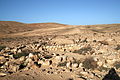 Nabatejský dům se zbytky cistern.
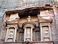 Nabatejská Pokladnice (Ad Deir) v Petře
 Nabatejská brána – Mamšit
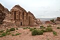 Klášter Ad Deir – Petra
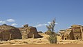 Mada'in Saleh Al-Hijr Hegra
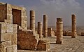 Nabatejský chrám – Avdat
 Mince krále Arety IV.
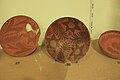 Nabatejská keramika
 Shivta – ruiny v Negevu
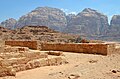 Nabatejský chrám – ruiny v údolí Wadi Rum
Odkazy
Reference
- ↑ a b c d e f Ottův slovník naučný/Nabatejci – Wikizdroje. cs.wikisource.org [online]. [cit. 2023-01-01]. Dostupné online.
- ↑ a b c d e f g h i j k l m n o p q r s t u Jordánská Petra, Nabatejské království a Nabatejci | Jordánsko na Světadílech. jordansko.svetadily.cz [online]. [cit. 2023-01-01]. Dostupné online.
- ↑ a b c d e Příběh tajemné Petry: loupežníci, kadidlo a strmý pád do dějin. skryté perly s Radynacestu.cz [online]. [cit. 2023-01-01]. Dostupné online.
- ↑ a b c d Cesty a památky. www.cestyapamatky.cz [online]. Start:2008- [cit. 2023-01-01]. Dostupné online.
- ↑ a b COJECO.CZ. Nabatejci – CoJeCo.cz. www.cojeco.cz [online]. [cit. 2023-01-01]. Dostupné online.
- ↑ a b c Nabatejci – Dějiny. www.dejiny.cz [online]. [cit. 2023-01-01]. Dostupné online.
- ↑ a b KRUMPHANZL, Filip. Království koření, zázrak uprostřed pouště: Nabatejci založili slávu Petry na vůních. epochaplus.cz [online]. [cit. 2023-01-01]. Dostupné online.
- ↑ Panteon, pantheon – ABZ.cz: slovník cizích slov. slovnik-cizich-slov.abz.cz [online]. [cit. 2023-01-01]. Dostupné online.
Související články
Externí odkazy
 Obrázky, zvuky či videa k tématu Nabatejci na Wikimedia Commons
Média použitá na této stránce
.jpg)
Autor: Carole Raddato from FRANKFURT, Germany, Licence: CC BY-SA 2.0
Remains of a Nabataean temple, Wadi Rum, Jordan

Autor: Bjornpa, Licence: CC BY-SA 3.0
Nabataean pottery, from Petra Archaeological Museum
Autor: Gibson's book: Qur'anic Geography, Licence: CC BY-SA 4.0
Many historians have puzzled over the early trade routes of the Nabataeans. Since there were no distinctive Nabataean cities at this time, most discussion on this topic disintegrates into vague generalities. However, in my book, The Nabataeans, Builders of Petra, I examine the Nabataean people in the light of their social standing, and present a case for seeing the Nabataeans as a people who were traditionally scorned and scoffed at. I point out that because of their low social standing, at least in their early history; they developed their own trade routes and watering systems in the Arabian desert. In the book I also compare them to modern day gypsies and Turkomen who quietly conduct trade in the Middle East to this very day, following the patterns set down by very ancient traders and merchants.
This paper is not focused on any particular theory, but rather presents a number of topics that should be considered when considering Nabataean trade. It starts by outlining the chronological development of Nabataean trade in very broad lines. It then moves on to examine various aspects of Nabataean trade.
Chronological Over View of Nabataean Trade Early History 1900 BC - 600 BC In my paper "A Short History of the Tribes of Northern Arabia" I point out that from 1900 BC to 600 BC, the Nabataeans were known as an Arab tribe that engaged in trading. While their brother tribe, the Qedarites, were known for their military prowess, the Nabataeans seem to be content with running camel caravans in the interior of what is Saudi Arabia today. Acting as merchants they linked Arabia, the Hagarites, Mesopotamia and Edom. I believe that this trade was shared with the other sons of Ishmael, who also were tribes conducting trade in Arabia at the same time.
During this period, the Nabataeans established small colonies in tent communities on the outskirts of many of the major centers of Arabia, Mesopotamia, and the Levant. Some examples of these communities are: Meda'in Saleh near Dedan the Lihyanite capital, Jenysos south of Gaza, Selah near Busheira, the Edomite Capital.
During this period, the major Arabian trade routes included: 1. The Central Arabian Desert Route. Goods traveled from Southern Arabia (Yemen) through the Arabian Peninsula to the land of Edom. From Edom goods moved north to Damascus or west to Egypt. 2. The Eastern Arabian Desert Route. Goods traveled from Southern Arabia (Oman) along the eastern coast by boat by Gerrhean merchants to ports in Mesopotamia. From here goods made their way to Babylon where they joined the Silk Road. Goods then traveled through Damascus to the Phoenicians on the Mediterranean Sea.
600 - 250 BC In the period from 600 BC - 250 BC the Nabataeans first began using boats to pirate on the Red Sea and later on the Mediterranean Sea, from the port of Gaza. This story is recorded for us by Diodorus. There is no evidence that they engaged in maritime trade at this time. Diodorus tells us: "After one has sailed past this country, the Laeanites Gulf comes next, about which are many inhabited villages of Arabs who are known as Nabataeans. This tribe occupies a large part of the coast and not a little of the country which stretches inland, and it has a people beyond telling and flocks and herds in multitude beyond belief. Now in ancient times these men observed justice and were content with the food which they received from their flocks, but later, after the kings of Alexandria had made the ways of the sea navigable for their merchants, these Arabs not only attacked the shipwrecked, but fitting out pirate ships and preyed upon the voyagers, imitating in their practice the savage and lawless ways of the Tauri of the Pontusl. Some time afterwards, however, they were caught on the high seas by some quadriremes and punished as they deserved." (III.43.4)
According to the Zenon Papyri, the Nabataeans were competing with the Mineans and the Gerrheans for the incense trade. These traders were using the overland routes.
250 - 100 BC Three kingdoms existed in southern Arabia. The two inside kingdoms faced the desert, and handled all of the contact with Arab traders. They did not allow frankincense to be moved by boat as the frankincense field lay between them and the coast. However, some of the states along the shore started using boats anyway. They would carry the frankincense to an island and Nabataean boats would pick it up and bringing it north to their new port at Leuce Come. From Leuce Come goods would travel up the coast to Aila, and then inland through the newly developing Nabataean Empire to Egypt, Damascus, Mesopotamia, Greece, and Rome.
During this period, the Ptolemies in Egypt built a series of ports down the African coast to facilitate the importing of elephants from around the African Horn. Nabataean boats carrying cargos from South Yemen to Leuce Come also added the Egyptian port of Berenike to their route. From Berenike goods were sent across the land bridge to Alexandria. During this time Indian and Chinese goods also started arriving at Arabia ports. They were also transported across land to the Mediterranean port of Alexandria where ships carried them to the various civilizations around the Mediterranean Sea. This Foreign trade became so intense that China and India sent trade ambassadors to the Middle East during this time.
For example, trade embassies which were exchanged between Philadelphos of Alexandria and the great Asoka of India. This clearly testifies to tentative direct relations between the Ptolemies of Egypt and India. (Kortenbeutel, op. cit., p29).
Along with this, an envoy of Chinese Emperor Wu-ti, of the Chinese Han dynasty made a visit to the Middle East in 138 - 122 BC. This envoy, Chang Ch'ien mentions a gift from the Arab king of jugglers from Rekeem, (the Nabataean name for Petra).
During this time the Himyarite kingdom in south Arabia began to grow significantly, as the Nabataeans increased their maritime trade with them. It appears that eventually the Nabataeans allied themselves with the Himyarites against the other kingdoms of South Arabia..
100 BC - 85 BC The Nabataean port city of Gaza seemed to be loosing its importance. Most Nabataean Arabian and Asian trade seemed to be passing through Alexandria. Gaza was eventually lost to Jewish control. The Nabataeans continued their expansion northwards at the expense of Gaza. They gained control of the ancient city of Damascus in 85 BC. This allowed them to completely dominate the land and sea routes from the east. The Nabataeans now controlled the Silk Road, the Frankincense Road, the King's Highway, and the maritime trade routes with India and Sri Lanka. The Nabataeans suddenly emerged as a world class economic power. At this point they then began to work hard on projecting a global image or wealth, opulence and honor. One of these projects was the construction of a world class capital city, Petra.
20-30 BC During the Roman campaign to south Yemen to discover the source of frankincense, the Nabataeans not only managed to destroy the Roman army through deception, they effectively used the Romans against the Hadramites and the Mineans. While they did not defeat these kingdoms, they severely weakened them so that the following year the Himyarites began to conquer them. Eventually the Himyarites took control of frankincense production, and all frankincense trade was hereafter conducted by ships to Nabataea, causing the Gerrhean civilization to crumble.
106 AD
At this point in history the Roman Empire acquired (not conquered) the Nabataean Empire. It appears that the Nabataeans sold their Empire to the Romans in order to gain Roman citizenship for their nobility, and also to gain monopoly over the East Asia trade.
Autor: Rc 13, Licence: CC BY-SA 4.0
Nabataean bronze coin from Petra showing Aretas IV in military dress standing left, holding a spear in his right hand and resting his left hand on sword in sheath, palm branch to left, Aramaic letter “Heth (H)” to right (15 mm, 2.5 g)
.jpg)
Autor: Ian Scott, Licence: CC BY-SA 2.0
Approaching the Nabatean-era gates (?) of ancient Mampsis (Mamshit or Kurnub). This was a key Nabatean town located on the trade route that ran overland south of the Dead Sea and through the Arabian desert. Mampsis was a key junction point where this caravan route met the north-south routes into Judea and was also a crucial stop-over on the way West toward Egypt. The city survived into the Byzantine period before trade patterns changed and the settlement was abandoned. Since the site was never re-occupied after the Byzantine era, its remains are remarkably well-preserved.
Autor: http://books.openedition.org/ifpo/4896?lang=en, Licence: CC BY-SA 4.0
This is the map of the Nabatean Kingdom

Autor: Zairon, Licence: CC BY-SA 4.0
Nabatean Temple, Avdat, Negev Desert, Israel
%2c_Petra_(26680852438).jpg)
Autor: Carole Raddato from FRANKFURT, Germany, Licence: CC BY-SA 2.0
It is one of the largest monuments in Petra, measuring 47m wide by 48.3m high. It was built on the model of the Khazna but here the bas- reliefs are replaced by niches to house sculptures. A columned portico extends of the façade; the interior is occupied by two side benches and altar against the rear wall. It was used as a biclinium for the meetings of religious associations. And dates to the early 2nd century AD, during the reign of King Rabel II. In the hall was reused as a Christian chapel and crosses were carved in the rear wall thus the name “Monastery” (Dayr in Arabic).
<a href="http://www.visitpetra.jo/DetailsPage/VisitPetra/LocationsInPetraDetailsEn.aspx?PID=26" rel="nofollow">www.visitpetra.jo/DetailsPage/VisitPetra/LocationsInPetra...</a>_(8136618664).jpg)
Autor: Basheer Olakara, Licence: CC BY 2.0
Mada'in Saleh, also called Al-Hijr or Hegra is an archaeological site located in the Al-Ula sector, within the Al Madinah Region of Saudi Arabia. A majority of the vestiges date from the Nabatean kingdom (1st century CE). The site constitutes the kingdom's southernmost and largest settlement after Petra, its capital. Traces of Lihyanite and Roman occupation before and after the Nabatean rule, respectively, can also be found in situ, while accounts from the Qur’an tell of an earlier settlement of the area by the tribe of Thamud in the 3rd millennium BC.
According to the central Islamic text, the Thamudis, who would carve out homes in the mountains, were punished by Allah for their persistent practice of idol worship and for conspiring to kill she-camel (as mentioned in the Qur'an), the non-believers being struck by an earthquake and lightning blasts. Thus, the site has earned a reputation down to contemporary times as a cursed place— an image which the national government is attempting to overcome as it seeks to develop Mada'in Saleh, officially protected as an archaeological site since 1972, for its tourism potential.
In 2008, for its well-preserved remains from late antiquity, especially the 131 rock-cut monumental tombs, with their elaborately ornamented façades, of the Nabatean kingdom,UNESCO proclaimed Mada'in Saleh as a site of patrimony, becoming Saudi Arabia's first World Heritage Site.
Autor: Someone35, Licence: CC BY-SA 3.0
shivta ruins in the negev desert

Autor: Mboesch, Licence: CC BY-SA 4.0
Lotz Cisterns: Ruine eines nabatäischen Hauses
.jpg)
Autor: David Berkowitz from New York, NY, USA, Licence: CC BY 2.0
Petra, Jordan, by David Berkowitz