Nejvyšší hory Francie

Nejvyšší hory Francie. Všechny nejvyšší vrcholy Francie leží v Alpách. Nejvyšší horou ve Francii je nejvyšší hora Alp a Evropy Mont Blanc.[1] Většina nejvyšších hor Francie se nachází v Masivu Mont Blanc v Horním Savojsku. Zde leží nejvíce vrcholů s nadmořskou výškou přes 4 000 metrů.[2] Vedle Mont Blancu zde výrazně vystupují horské masivy Grandes Jorasses a Aiguille Verte. Dále je ve Francouzských Alpách většina nejvyšších hor koncentrována v masivu Écrins, který je součástí Dauphinéských Alp. K hlavním vrcholům zde náleží Barre des Écrins, La Meije a Mont Pelvoux.[3] Dalšími horskými oblastmi s nejvyšším horami Francie jsou masiv Vanoise a Grajské Alpy.
20 nejvyšších hor Francie


Ve výčtu jsou zastoupeny pouze vrcholy s prominencí vyšší než 465 metrů.[4]
20 nejvyšších hor Francie s prominencí vyšší než 100 metrů


Ve výčtu jsou zastoupeny pouze vrcholy s prominencí vyšší než 100 metrů.[4]
10 vrcholů s nejvyšší prominencí


10 nejprominentnějších hor ve Francii.[5]
| Vrchol | Pohoří | Departement/region | Výška (m) | Prominence (m) | Izolace (km) | |
|---|---|---|---|---|---|---|
| 1 | Mont Blanc | Masiv Mont Blanc | Horní Savojsko | 4 808 | 4 695 | 2 812 |
| 2 | Monte Cinto | Masiv Monte Cinto | Korsika | 2 706 | 2 706 | 223,3 |
| 3 | Barre des Écrins | Dauphinéské Alpy | Horní Alpy | 4 102 | 2 044 | 107,3 |
| 4 | Chamechaude | Chartreuse | Isère | 2 082 | 1 769 | 17 |
| 5 | Arcalod | Bauges | Savojsko/Horní Savojsko | 2 217 | 1 719 | 15,7 |
| 6 | Pointe Percée | Aravis | Horní Savojsko | 2 750 | 1 640 | 17,7 |
| 7 | Puy de Sancy | Francouzské středohoří | Puy-de-Dôme | 1 885 | 1 578 | 221,6 |
| 8 | l'Obiou | Devoluy | Isère | 2 789 | 1 541 | 22 |
| 9 | La Tournette | Bornes | Horní Savojsko | 2 351 | 1 514 | 10,7 |
| 10 | Taillefer | Dauphinéské Alpy | Isère | 2 857 | 1 490 | 10,1 |
Reference
- ↑ Universum, všeobecná encyklopedie. 6. díl. 1. vyd. Praha: Odeon, Euromedia Group, 2001. 655 s. ISBN 80-207-1068-X. S. 195.
- ↑ IVO, Petr. Francouzské Alpy. 1. vyd. Ostrava: Mirago, 1999. 141 s. ISBN 80-85922-62-2. S. 15.
- ↑ Dauphine Alps [online]. Peakbagger.com, 1987 [cit. 2021-03-01]. Dostupné online. (anglicky)
- ↑ a b Alpine 4000-meter Peaks [online]. Peakbagger.com, 1987 [cit. 2021-03-01]. Dostupné online. (anglicky)
- ↑ France Peaks with 600 meters of Prominence [online]. Peakbagger.com, 1987 [cit. 2022-03-01]. Dostupné online. (anglicky)
Externí odkazy
Související články
Média použitá na této stránce
Mont Maudit depuis la Pointe Helbronner
Autor: MOSSOT, Licence: CC BY-SA 3.0
Pré de Madame Carle - Arrivée sur le parking, la barre des Ecrins et le glacier Blanc
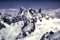
The Grandes Jorasses (4208 m) and Dent du Geant (4103 m), near Chamonix, France. The Grandes Jorasses is the (apparent) highest of the peaks in the picture, one third of the way across the picture from the left hand side. The Dent du Geant (4103 m) is the dark “tooth” on the right of the range (about one third in from the right of the picture). I believe the central dark peak is Mont Mallet (3989 m) and the ill-defined “peak” between Mont Mallet and the Dent du Geant is the Aiguille de Rochefort.
Autor: Ximonic, Simo Räsänen, Licence: CC BY-SA 3.0
Chamonix valley and Mont Blanc as seen from la Flégère in the end of 2010 July.
Autor: Guilhem Vellut from Annecy, France, Licence: CC BY 2.0
La Tournette @ Lake Annecy @ Saint-Jorioz
Autor: John Johnston, Licence: CC BY 2.0
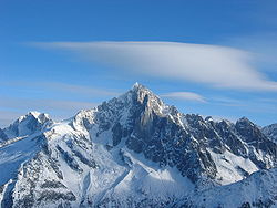
Aiguille Verte, Massif du Mont Blanc
Grandes Jorasses seen from the Vallée Blanche
Face Est de l'arcalod, vue de la pointe de la chorionde
© Guillaume Piolle, CC BY 3.0
La Meije moutain seen from the Emparis plateau (French Alps).


