Nejvyšší hory Spojených států amerických

Nejvyšší hory Spojených států amerických. Nejvyšší horou Spojených států amerických je Denali (dříve Mount McKinley) na Aljašce, v Aljašských horách. S nadmořskou výškou 6 190[1] metrů je jediným vrcholem ve Spojených státech a v Severní Americe, který má výšku přes 6 000 metrů.[2][3] Celkem čtyři hory s prominencí vyšší než 500 metrů jsou vyšší než 5 000 metrů a všechny zbylé, z uvedených padesáti, jsou vyšší než 4 200 metrů. Všech deset nejvyšších vrcholů Spojených států leží na Aljašce.[4] Z padesáti nejvyšších hor s promienncí vyšší než 500 metrů leží 28 v Coloradu, 14 na Aljašce, 7 v Kalifornii a 1 ve státě Washington. Z třiceti nejvyšších hor Spojených států s prominencí vyšší než 500 metrů leží nejvíce 12 ve Skalnatých horách (především v pohořích Sawatch Range, Front Range, San Juan Mountains a Sangre de Cristo Mountains), 7 v pohoří sv. Eliáše, 3 v Aljašských horách, po dvou ve Wrangellově pohoří a Sieře Nevadě a jeden vrchol leží v Kaskádovém pohoří.
50 nejvyšších hor Spojených států


Ve výčtu jsou zastoupeny pouze vrcholy s prominencí vyšší než 500 metrů.
30 vrcholů s nejvyšší prominencí


Z třiceti nejprominentnějších hor ve Spojených státech se nejvíce pět nachází v Kaskádovém pohoří a stejný počet v Aleutském pohoří. Dále čtyři v pohoří svatého Eliáše a tři v Aljašských horách. Nejvíce nejprominentnějších vrcholů leží na Aljašce (šestnáct), po čtyřech ve státě Washington a v Kalifornii, po dvou ve státě Havaj a v Nevadě a jeden v Oregonu.[5]
30 nejvyšších hor Spojených států s prominencí vyšší než 100 metrů


Z dvaceti nejvyšších hor Spojených států s prominencí vyšší než 100 metrů leží devatenáct na Aljašce a jedna v Kalifornii. Většina se nachází v pohoří svatého Eliáše a v Aljašských horách.[4]
Reference
V tomto článku byly použity překlady textů z článků List of the highest major summits of the United States na anglické Wikipedii a List of Ultras of the United States na anglické Wikipedii.
- ↑ New Elevation for Nation’s Highest Peak – Revised Denali Elevation Announced. GISuser [online]. Spatial Media, 2015-09-02 [cit. 2022-08-25]. Dostupné online.
- ↑ Merriam-Webster's Geographical Dictionary. 3. vyd. Springfield, Massachusetts, U. S. A.: Merriam-Webster, Incorporporated, Publishers, 1997. 1361 s. Dostupné online. ISBN 0-87779-546-0. (anglicky)
- ↑ Denali [online]. United States Geological Survey, 1981 [cit. 2021-08-09]. Dostupné v archivu pořízeném dne 2021-03-17. (anglicky)
- ↑ a b United States 14,000-foot Peaks [online]. Peakbagger.com, 1987 [cit. 2021-08-09]. Dostupné online. (anglicky)
- ↑ USA Peaks with 6000 feet of Prominence [online]. Peakbagger.com, 1987 [cit. 2021-08-09]. Dostupné online. (anglicky)
Související články
- Nejvyšší hory Severní Ameriky
- Nejvyšší hory Jižní Ameriky
- Nejvyšší hory Střední Ameriky
- Seznam fourteeners Spojených států amerických
Externí odkazy
 Obrázky, zvuky či videa k tématu Nejvyšší hory Spojených států na Wikimedia Commons
Média použitá na této stránce
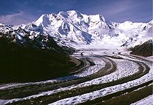
Mount Blackburn from the southeast, looking up the Kennicott Glacier. Wrangell-St. Elias National Park and Preserve, Alaska, USA
Autor: Geographer (diskuse · příspěvky), Licence: CC BY 1.0
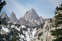
Mount Whitney
Autor: Bala from Seattle, USA, Licence: CC BY 2.0
We went in search of the famous 'Trout Lake' - but arrived at a creek. Nobody seemed to know where this 'lake' was.
We saw a trail and hiked along it for a bit and came to a campground after a couple of miles. It was there that we found out that the lake dried up in the 70s.
I had to make do with a long exposure on the creek to simulate a 'lake'.Autor: AWWE83, Licence: CC BY-SA 4.0
Der Alsek River durchfließt am Fuße des Mount Faiweather (4.663 m) den Alsek Lake (Alaska) und nagt an seinen Gletschern.
Autor: Navin75 https://www.flickr.com/people/navin75/, Licence: CC BY-SA 2.0
Haleakala National Park in Maui, Hawaii, USA.
Autor: David Herrera from Albuquerque, NM, Bernalillo, Licence: CC BY 2.0
Mount Elbert, taken from Twin Lakes.
IMG_2285Autor: Rick Kimpel from Spring, TX, USA, Cropped and color-corrected by Daniel Case prior to upload, Licence: CC BY-SA 2.0
View east from scenic overlook along Colorado State Highway 82
(c) Kelvin Kay na projektu Wikipedie v jazyce angličtina, CC BY-SA 3.0
Mount Rainier reflected in Reflection lake.
Icy Bay, Tyndall Glacier, and Mount St. Elias
Flight paths: caltopo.com/m/031CAutor: en:user:Geographer, Licence: CC BY 1.0
The North face of San Jacinto Mountains, the northernmost of the Peninsular Ranges, in Riverside County, Southern California.
- From right to left the named summits in this picture are: Folly Peak, 10,480+ feet, San Jacinto Peak, 10,804 feet, Miller Peak, 10,400+ feet, and Cornell Peak, 9750 feet.
- Protected within the Santa Rosa and San Jacinto Mountains National Monument, and the San Bernardino National Forest.
- The steep escarpment of its north face climbs over 10,000 feet (3 km) in 7 miles (11.3 km). It is the steepest escaprtment in North America. Snow Creek can be seen as the snow-filled gully reaching to the summit. The lower reaches of Snow Creek belong to the Palm Springs Water District, which strictly enforces a ban on trespassing.
Wonder Lake and Denali (original Flickr title: Reflection Pond)
Mount Foraker (17,400 feet) towers above Soldiers from B Company, 1st Battalion, 52nd Aviation Regiment as they offload equipment and supplies from a CH-47F Chinook helicopter after landing on Kahiltna Glacier. Three crews from the U.S. Army Alaska Aviation Task Force spent the week in Talkeetna, Alaska, training in high altitude flying through the Alaska Range. The mission for Sunday, April 24, included continuing a longstanding partnership with the National Park Service to shuttle equipment and supplies to the Park Service base camp on Kahiltna Glacier for the upcoming climbing season on Denali.


