Nottinghamshire
| Nottinghamshire | |
 Southwellská katedrála | |
| Geografie | |
|---|---|
| Souřadnice | 53°10′ s. š., 1° z. d. |
| Rozloha | 2 159,325 3 km² |
| Geodata (OSM) | OSM, WMF |
| Obyvatelstvo | |
| Počet obyvatel | 1 154 195 (2018) |
| Hustota zalidnění | 534,5 obyv./km² |
| Oficiální web | www |
| Některá data mohou pocházet z datové položky. | |
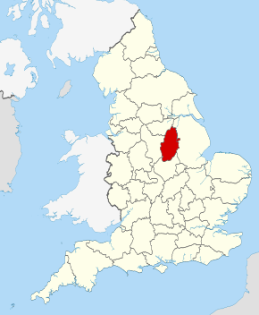
Nottinghamshire ([ˈnotiŋəmˌšiə(r), ˈnotiŋəmˌšə(r)], zkráceně Notts [nots]) je anglické nemetropolitní, ceremoniální a tradiční hrabství. Na severozápadě sousedí se South Yorkshire, na východě s Lincolnshire, na jihu s Leicestershire a na západě pak s Derbyshire. Žije zde přibližně 1,15 milionu[1] obyvatel.
Administrativní členění
Hrabství se dělí na osm distriktů:
- Rushcliffe
- Broxtowe
- Ashfield
- Gedling
- Newark and Sherwood
- Mansfield
- Bassetlaw
- City of Nottingham (unitary authority)
Reference
- ↑ Estimates of the population for the UK, England and Wales, Scotland and Northern Ireland. Dostupné online.
Externí odkazy
 Obrázky, zvuky či videa k tématu Nottinghamshire ve Wikimedia Commons
Média použitá na této stránce
Flag of Nottinghamshire
Autor: Nilfanion, Licence: CC BY-SA 3.0
Location of the ceremonial county of Nottinghamshire within England.
Autor:
- Georgian_heraldry_motto.svg: Gaeser
- County_Flag_of_Nottinghamshire.png: *Blason_damblain.svg: Manassas
- derivative work: Jza84 (talk)
-
Coat_of_Arms_of_Henry_VII_of_England_(1485-1509).svg: Sodacan
 Tento PNG grafika byl vytvořen programem Inkscape.
- Armoiries_de_Rolshausen.svg: Caranorn
- Héraldique_meuble_Gerbe_de_blé.svg: Bruno Vallette
- Arms_of_the_Greater_London_Council.svg: Greentubing
- derivative work: Jza84 (talk)
The Coat of arms of Nottinghamshire County Council.
Autor: DeFacto, Licence: CC BY-SA 4.0
Southwell Minster, Nottinghamshire - from the north-west


