Obce v Estonsku


Samosprávná obec (estonsky omavalitsus) je nižší samosprávné územní jednotka v Estonsku. Každá obec disponuje vlastními úřady výkonné a zákonodárné moci.
Obce v Estonsku jsou dvojího typu:
Po rozsáhlé správní reformě z roku 2017 se počet obcí ustálil na čísle 79 (z toho 15 obcí městského typu a 64 obcí venkovského typu). Nejlidnatější obcí je Tallinn, ve kterém žije přibližně třetina všech obyvatel státu. Nejmenší obec Ruhnu má pouhých 131 obyvatel. Rozlohou největší je obec Saaremaa, která zahrnuje stejnojmenný největší estonský ostrov. Samosprávné obce sestávají z měst (linn), městysů (alev), městeček (alevik) a vesnic (küla). V roce 2020 existovalo v Estonsku 47 měst, 12 městysů, 187 městeček a více než 4,4 tisíce vesnic.[1]
Přehled obcí
Následující tabulka zahrnuje všech 79 obcí. Primárně jsou seřazeny podle příslušnosti ke kraji a abecedy. Řádky lze však též seřadit podle typu obce, počtu obyvatel, rozlohy obce a hustoty zalidnění.
| Typ | Obec | Obyvatelstvo (1.1.2020)[2] | Rozloha (km²)[3] | Hustota zalidnění (obyv./km²) | Příslušnost ke kraji |
|---|---|---|---|---|---|
| V | Anija | 6 217 | 533,0 | 11,7 | Harjumaa |
| V | Harku | 15 197 | 159,0 | 95,6 | Harjumaa |
| V | Jõelähtme | 6 553 | 211,4 | 31,0 | Harjumaa |
| M | Keila | 10 044 | 11,2 | 896,8 | Harjumaa |
| V | Kiili | 5 657 | 100,9 | 56,1 | Harjumaa |
| V | Kose | 7 177 | 532,8 | 13,5 | Harjumaa |
| V | Kuusalu | 6 413 | 709,5 | 9,0 | Harjumaa |
| M | Loksa | 2 541 | 3,8 | 668,7 | Harjumaa |
| V | Lääne-Harju | 12 558 | 645,7 | 19,4 | Harjumaa |
| M | Maardu | 15 445 | 23,4 | 660,0 | Harjumaa |
| V | Raasiku | 5 050 | 159,0 | 31,8 | Harjumaa |
| V | Rae | 20 641 | 206,8 | 99,8 | Harjumaa |
| V | Saku | 10 435 | 170,0 | 61,4 | Harjumaa |
| V | Saue | 22 929 | 627,6 | 36,5 | Harjumaa |
| M | Tallinn | 437 619 | 159,4 | 2 745,4 | Harjumaa |
| V | Viimsi | 20 553 | 73,3 | 280,4 | Harjumaa |
| V | Hiiumaa | 9 315 | 1 032,4 | 9,0 | Hiiumaa |
| V | Alutaguse | 4 680 | 1 458,6 | 3,2 | Ida-Virumaa |
| V | Jõhvi | 11 852 | 123,9 | 95,7 | Ida-Virumaa |
| M | Kohtla-Järve | 33 197 | 39,4 | 842,6 | Ida-Virumaa |
| V | Lüganuse | 8 374 | 598,6 | 14,0 | Ida-Virumaa |
| M | Narva | 54 409 | 68,7 | 792,0 | Ida-Virumaa |
| M | Narva-Jõesuu | 4 559 | 404,7 | 11,3 | Ida-Virumaa |
| M | Sillamäe | 12 480 | 11,9 | 1 048,7 | Ida-Virumaa |
| V | Toila | 4 708 | 265,8 | 17,7 | Ida-Virumaa |
| V | Jõgeva | 13 407 | 1 039,7 | 12,9 | Jõgevamaa |
| V | Mustvee | 5 350 | 615,6 | 8,7 | Jõgevamaa |
| V | Põltsamaa | 9 685 | 889,6 | 10,9 | Jõgevamaa |
| V | Järva | 8 937 | 1 222,8 | 7,3 | Järvamaa |
| M | Paide | 10 463 | 442,9 | 23,6 | Järvamaa |
| V | Türi | 10 774 | 1 008,4 | 10,7 | Järvamaa |
| M | Haapsalu | 13 075 | 271,8 | 48,1 | Läänemaa |
| V | Lääne-Nigula | 6 983 | 1 448,8 | 4,8 | Läänemaa |
| V | Vormsi | 386 | 95,0 | 4,1 | Läänemaa |
| V | Haljala | 4 312 | 549,1 | 7,9 | Lääne-Virumaa |
| V | Kadrina | 4 790 | 353,9 | 13,5 | Lääne-Virumaa |
| M | Rakvere | 15 085 | 10,8 | 1 396,8 | Lääne-Virumaa |
| V | Rakvere | 5 593 | 294,7 | 19,0 | Lääne-Virumaa |
| V | Tapa | 10 761 | 479,7 | 22,4 | Lääne-Virumaa |
| V | Vinni | 6 849 | 1 012,9 | 6,8 | Lääne-Virumaa |
| V | Viru-Nigula | 5 690 | 312,2 | 18,2 | Lääne-Virumaa |
| V | Väike-Maarja | 5 782 | 682,5 | 8,5 | Lääne-Virumaa |
| V | Kanepi | 4 662 | 524,7 | 8,9 | Põlvamaa |
| V | Põlva | 13 717 | 705,9 | 19,4 | Põlvamaa |
| V | Räpina | 6 268 | 592,8 | 10,6 | Põlvamaa |
| V | Häädemeeste | 4 823 | 494,3 | 9,8 | Pärnumaa |
| V | Kihnu | 690 | 17,3 | 39,9 | Pärnumaa |
| V | Lääneranna | 5 242 | 1 362,7 | 3,8 | Pärnumaa |
| V | Põhja-Pärnumaa | 8 190 | 1 010,6 | 8,1 | Pärnumaa |
| M | Pärnu | 50 914 | 857,9 | 59,3 | Pärnumaa |
| V | Saarde | 4 505 | 1 064,8 | 4,2 | Pärnumaa |
| V | Tori | 11 821 | 611,1 | 19,3 | Pärnumaa |
| V | Kehtna | 5 460 | 512,0 | 10,7 | Raplamaa |
| V | Kohila | 7 286 | 230,1 | 31,7 | Raplamaa |
| V | Märjamaa | 7 427 | 1 163,5 | 6,4 | Raplamaa |
| V | Rapla | 13 109 | 859,5 | 15,3 | Raplamaa |
| V | Muhu | 1 879 | 207,9 | 9,0 | Saaremaa |
| V | Ruhnu | 131 | 11,9 | 11,0 | Saaremaa |
| V | Saaremaa | 31 073 | 2 717,8 | 11,4 | Saaremaa |
| V | Elva | 14 630 | 732,3 | 20,0 | Tartumaa |
| V | Kambja | 11 477 | 275,2 | 41,7 | Tartumaa |
| V | Kastre | 5 263 | 492,8 | 10,7 | Tartumaa |
| V | Luunja | 5 002 | 131,8 | 38,0 | Tartumaa |
| V | Nõo | 4 287 | 169,1 | 25,4 | Tartumaa |
| V | Peipsiääre | 5 373 | 652,2 | 8,2 | Tartumaa |
| M | Tartu | 96 123 | 154,0 | 624,2 | Tartumaa |
| V | Tartu | 11 162 | 742,1 | 15,0 | Tartumaa |
| V | Otepää | 6 404 | 520,2 | 12,3 | Valgamaa |
| V | Tõrva | 6 120 | 647,2 | 9,5 | Valgamaa |
| V | Valga | 15 680 | 749,7 | 20,9 | Valgamaa |
| V | Mulgi | 7 460 | 880,7 | 8,5 | Viljandimaa |
| V | Põhja-Sakala | 7 911 | 1 153,0 | 6,9 | Viljandimaa |
| M | Viljandi | 17 104 | 14,7 | 1 163,5 | Viljandimaa |
| V | Viljandi | 13 686 | 1 371,6 | 10,0 | Viljandimaa |
| V | Antsla | 4 398 | 410,5 | 10,7 | Võrumaa |
| V | Rõuge | 5 311 | 933,2 | 5,7 | Võrumaa |
| V | Setomaa | 3 175 | 463,1 | 6,9 | Võrumaa |
| M | Võru | 11 727 | 14,0 | 837,6 | Võrumaa |
| V | Võru | 10 804 | 952,3 | 11,3 | Võrumaa |
| Estonsko CELKEM | 1 328 976 | 43 465,4 | 30.6 |
Mapy obcí
- Harjumaa
- Hiiumaa
- Ida-Virumaa
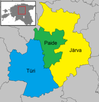
- Järvamaa
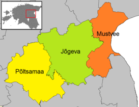
- Jõgevamaa
- Läänemaa
- Lääne-Virumaa
- Pärnumaa
- Põlvamaa
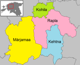
- Raplamaa
- Saaremaa
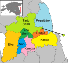
- Tartumaa
- Valgamaa
- Viljandimaa
- Võrumaa
Odkazy
Reference
- ↑ Administrative and Settlement Division [online]. Republic of Estonia Land Board: Geoportal [cit. 2020-12-01]. Dostupné online. (anglicky)
- ↑ RV0282U: POPULATION AFTER THE 2017 ADMINISTRATIVE REFORM, 1 JANUARY by Sex, Place of residence, Year and Age group [online]. Statistics Estonia [cit. 2020-12-01]. Dostupné online. (anglicky)
- ↑ Maakatastri statistika [online]. Republic of Estonia Land Board: Geoportal [cit. 2020-12-01]. Dostupné online. (estonsky)
Související články
- Administrativní dělení Estonska
- Kraje v Estonsku
- Seznam měst v Estonsku
- Seznam estonských městysů
- Seznam estonských městeček
Externí odkazy
 Obrázky, zvuky či videa k tématu seznam estonských obcí na Wikimedia Commons
Média použitá na této stránce
Autor: Flying Saucer, Licence: CC BY-SA 4.0
Map of the municipalities of Põlva County after the Administrative Reform of Estonia in 2017.
Autor: Flying Saucer, Licence: CC BY-SA 4.0
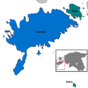
Map of the municipalities of Saare county in Estonia, 2017–
Autor: Flying Saucer, Licence: CC BY-SA 4.0
Map of the municipalities of Võru County after the Administrative Reform of Estonia in 2017.
Autor: Flying Saucer, Licence: CC BY-SA 4.0
Map of the municipalities of Pärnu County after the Administrative Reform of Estonia in 2017.
Autor: Flying Saucer, Licence: CC BY-SA 4.0
Map of the municipalities of Harju County after the Administrative Reform of Estonia in 2017.
Autor: Flying Saucer, Licence: CC BY-SA 4.0
Map of the municipalities of Jõgeva County after the Administrative Reform of Estonia in 2017.
Autor: Flying Saucer, Licence: CC BY-SA 4.0
Map of the municipalities of Ida-Viru County after the Administrative Reform of Estonia in 2017.
Map of the municipalities of Estonia after the 2017 municipal reform. Created by Rarelibra 15:43, 20 December 2006 (UTC) for public domain use, using MapInfo Professional v8.5 and various mapping resources.
Autor: Staberinde, Licence: CC BY-SA 3.0
Estonian administrative divisions 2017
Autor: Flying Saucer, Licence: CC BY-SA 4.0
Map of the municipalities of Viljandi County after the Administrative Reform of Estonia in 2017.
Autor: Flying Saucer, Licence: CC BY-SA 4.0
Map of the municipalities of Lääne-Viru County after the Administrative Reform of Estonia in 2017.
Autor: Flying Saucer, Licence: CC BY-SA 4.0
Map of the municipalities of Tartu County after the Administrative Reform of Estonia in 2017.
Autor: Flying Saucer, Licence: CC BY-SA 4.0
Map of the municipalities of Järva County after the Administrative Reform of Estonia in 2017.
Autor: Flying Saucer, Licence: CC BY-SA 4.0
Map of the municipalities of Hiiu County after the Administrative Reform of Estonia in 2017.
Autor: Flying Saucer, Licence: CC BY-SA 4.0
Map of the municipalities of Rapla County after the Administrative Reform of Estonia in 2017.
Autor: Flying Saucer, Licence: CC BY-SA 4.0
Map of the municipalities of Lääne County after the Administrative Reform of Estonia in 2017.
Autor: Flying Saucer, Licence: CC BY-SA 4.0
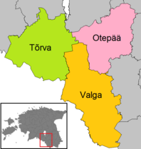
Map of the municipalities of Valga County after the Administrative Reform of Estonia in 2017.


