Ostrov Jamese Rosse
| Ostrov Jamese Rosse | |
|---|---|
 | |
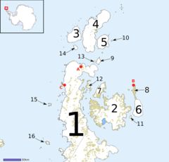
 Mapa Grahamovy země, Ostrov Jamese Rosse označen číslem 2 | |
| Topografie | |
| Zeměpisné souřadnice | 64°10′ j. š., 57°45′ z. d. |
| Některá data mohou pocházet z datové položky. | |
Ostrov Jamese Rosse (anglicky James Ross Island [ˌdžeimz ˌros ˈailənd]) je velký ostrov v Jižním oceánu u pobřeží Antarktidy, východně od nejsevernějšího výběžku Antarktického poloostrova, od kterého je oddělen průlivem prince Gustava. Ostrov Jamese Rosse (James Ross Island) není totožný s mnohem známějším ostrovem v Rossově moři pojmenovaným Rossův ostrov (Ross Island).
Geografická charakteristika
Ostrov s rozlohou přibližně 2500 km² je velmi členitý a ze 70 až 80 % je pokryt ledovcem, který dosahuje nejvyšší výšky 1630 m n. m.
Historie mapování
Oblast zmapovala v říjnu 1903 švédská antarktická expedice vedená Otto Nordenskjöldem. Jméno ostrov dostal po britském průzkumníkovi J. C. Rossovi, který při expedici v roce 1842 zhruba zakreslil množství míst na východní straně ostrova.
Mendelova polární stanice
V severní odledněné části ostrova (Ulu Peninsula), která má rozlohu asi 160 km², je od roku 2007 zprovozněna česká Mendelova polární stanice, která je majetkem brněnské Masarykovy univerzity.
Zajímavosti
Na ostrově byly v roce 1986 nalezeny fosilní pozůstatky prvního dinosaura objeveného v oblasti Antarktidy (v sedimentech geologického souvrství Snow Hill Island). Argentinští geologové Eduardo Oliveiro a Roberto Scasso nalezli zkamenělé pozůstatky středně velkého ankylosaura, který byl v roce 2006 pojmenován Antarctopelta oliveroi. V roce 2013 byl vědecky popsán další dinosaurus z tohoto místa, ornitopod Trinisaura santamartaensis.[1]
Bylo také zjištěno že v období pozdní křídy (geologický věk kampán) byly v této oblasti velmi rozšířené rozsáhlé požáry, které značně ovlivňovaly podobu místní vegetace.[2]
Odkazy
Externí odkazy
 Obrázky, zvuky či videa k tématu Ostrov Jamese Rosse na Wikimedia Commons
Reference
- ↑ SOCHA, Vladimír. Objeven další dinosaurus v Antarktidě. Ilustrace William Stout. DinosaurusBlog [online]. 2013-01-12 [cit. 2017-11-25]. Dostupné online.
- ↑ Jorge de Lima, F.; et al. (2021). Wildfires in the Campanian of James Ross Island: a new macro-charcoal record for the Antarctic Peninsula. Polar Research. 40: 5487. doi: https://doi.org/10.33265/polar.v40.5487
Literatura
- PROŠEK, Pavel a kol. Antarktida. Praha: Academia, 2013. 345 s. ISBN 978-80-200-2140-3.
- ADÁMEK, Hynek. Češi v Antarktidě. Praha: Freytag & Berndt, 2010. 142 s. ISBN 978-80-86236-23-0 (v publ. uvedeno chybně 978-80-8623-623-0).
Média použitá na této stránce
James Ross Island from NASA's DC-8 aircraft during an AirSAR 2004 mission over the Antarctic Peninsula.
James Ross Island captured by NASA photographer James Ross (no relation), from NASA's DC-8 aircraft during an AirSAR 2004 mission over the Antarctic Peninsula. James Ross Island, named for 19th century British polar explorer Sir James Clark Ross, is located at the northern tip of the Antarctic Peninsula. The island is about 1500 m high and 40-60 km wide. In recent decades, the area has experienced significant atmospheric warming (about 2 degrees C since 1950), which has triggered a vast and spectacular retreat of its floating ice shelves, glacier reduction, a decrease in permanent snow cover and a lengthening of the melt season. AirSAR 2004 is a three-week expedition in Central and South America by an international team of scientists that is using an all-weather imaging tool, called the Airborne Synthetic Aperture Radar (AirSAR), located onboard NASA's DC-8 airborne laboratory. Scientists from many parts of the world are combining ground research with NASA's AirSAR technology to improve and expand on the quality of research they are able to conduct. These photos are from the DC-8 aircraft while flying an AirSAR mission over Antarctica. The Antarctic Peninsula is more similar to Alaska and Patagonia than to the rest of the Antarctic continent. It is drained by fast glaciers, receives abundant precipitation, and melts significantly in the summer months. This region is being studied by NASA using a DC-8 equipped with the Airborne Synthetic Aperture Radar developed by scientists from NASA’s Jet Propulsion Laboratory. AirSAR will provide a baseline model and unprecedented mapping of the region. This data will make it possible to determine whether the warming trend is slowing, continuing or accelerating. AirSAR will also provide reliable information on ice shelf thickness to measure the contribution of the glaciers to sea level.
AirSAR collects multi-frequency and multi-polarization radar data for a variety of science applications. It also acquires data in interferometric modes, providing topographic information (cross-track mode) or ocean current information (along-track interferometry). This March 2004 deployment was planned to:
- Study the extent and distribution of archeological Mayan civilization (using foliage-penetrating radar)
- Study the glaciers of Patagonia and the Antarctic peninsula
- Investigate new techniques for the measurement of the forest structure of dense tropical forests
- Fill in the largest "void" in the SRTM-derived map of South American topography
- Collect additional data for various research initiatives
During the deployment data is collected over Central and South America and Antarctica. During the approximately 100 flight hours, AirSAR is acquiring polarimetric and/or interferometric data along a 20,000 km track, or about 200,000 sq. km of data over 40 sites for 30 scientists. AirSAR will collect data related to the following NASA Code YS science programs: - Cryospheric Science
- Land Cover/Land Use Change
- Natural Hazards
- Physical Oceanography
- Terrestrial Ecology
- Hydrology
NASA used a DC-8 aircraft as a flying science laboratory. The platform aircraft, was based at NASA's Dryden Flight Research Center, Edwards, Calif., collected data for many experiments in support of scientific projects serving the world scientific community. Included in this community were NASA, federal, state, academic and foreign investigators. Data gathered by the DC-8 at flight altitude and by remote sensing has been used for scientific studies in archeology, ecology, geography, hydrology, meteorology, oceanography, volcanology, atmospheric chemistry, soil science and biology.
Autor: Alexrk2, Licence: CC BY-SA 3.0
Location map Antarctica, Azimuthal equidistant projection
Islands near the north end of the Antarctic Peninsula


