Outarville
| Outarville | |
|---|---|
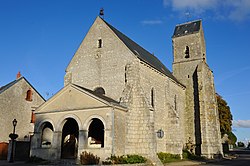
© Croquant / Wikimedia Commons, CC BY-SA 3.0 Kostel Saint-Laurent | |
| Poloha | |
| Souřadnice | 48°12′41″ s. š., 2°1′14″ v. d. |
| Nadmořská výška | 120–139 m n. m. |
| Stát | |
| Region | Centre-Val de Loire |
| Departement | Loiret |
| Arrondissement | Pithiviers |
| Kanton | Pithiviers |
| Rozloha a obyvatelstvo | |
| Rozloha | 46,6 km² |
| Počet obyvatel | 1 312 (2019)[1] |
| Hustota zalidnění | 28,1 obyv./km² |
| Správa | |
| Oficiální web | www |
| PSČ | 45480 |
| INSEE | 45240 |
| Některá data mohou pocházet z datové položky. | |
Outarville je francouzská obec v departementu Loiret v regionu Centre-Val de Loire. Žije zde přibližně 1 300[1] obyvatel.
Poloha obce
Obec leží na severu departementu Loiret u hranic s departementem Eure-et-Loir.
Sousední obce
 | Boisseaux | Erceville | Autruy-sur-Juine Charmont-en-Beauce |  |
| Oinville-Saint-Liphard (Eure-et-Loir) | Léouville | |||
| Toury (Eure-et-Loir) Chaussy | Bazoches-les-Gallerandes | Greneville-en-Beauce |
Vývoj počtu obyvatel
Odkazy
Reference
- ↑ a b Populations légales 2019. 12. ledna 2022. Dostupné online.
Související články
Externí odkazy
 Obrázky, zvuky či videa k tématu Outarville na Wikimedia Commons
Média použitá na této stránce
Autor: Superbenjamin, Licence: CC BY-SA 4.0
Blank administrative map of France for geo-location purpose, with regions and departements distinguished. Approximate scale : 1:3,000,000
A stylized arrow pointing north.
A stylized arrow pointing west.
A stylized arrow pointing east.
A stylized arrow pointing south.
Autor: Bluebear2, Licence: CC BY-SA 3.0
Blason de la ville d'Outarville (45): D'azur aux trois gerbes de blé d'or, liées de gueules
© Croquant / Wikimedia Commons, CC BY-SA 3.0
Église Saint-Laurent, Outarville, Loiret, France


