Padang
| Padang Kota Padang | |
|---|---|
 | |
 znak | |
| Poloha | |
| Souřadnice | 0°57′ j. š., 100°21′11″ v. d. |
| Stát | |
| provincie | Západní Sumatra |
 Padang | |
| Rozloha a obyvatelstvo | |
| Rozloha | 695 km² |
| Počet obyvatel | 1 024 906 (2014) |
| Hustota zalidnění | 1 474,7 obyv./km² |
| Správa | |
| Starosta | Mahyeldi Ansharullah |
| Vznik | 7. srpna 1669 |
| Oficiální web | www |
| Telefonní předvolba | +62 751 |
| Některá data mohou pocházet z datové položky. | |
Padang (indonéská výslovnost: [ˈpadaŋ]) je největší město na západním pobřeží Sumatry a hlavní město provincie Západní Sumatra. Rozkládá se na území o velikosti 695 km² a v roce 2014 v něm žilo 1 024 906 obyvatel.
Demografie
Historický vývoj počtu obyvatel
| Rok | Počet obyvatel | ±% |
|---|---|---|
| 1819 | ||
| 1874 | +194,1 | |
| 1930 | +108,2 | |
| 1971 | +276,4 | |
| 1980 | +145,3 | |
| 1990 | +31,3 | |
| 2010 | +42,6 | |
| 2013 | +2,6 |

Panorama města
Administrativní členění
Město Padang je rozděleno do 11 distriktů (kecamatan):
- Bungus Teluk Kabung
- Koto Tangah
- Kuranji
- Lubuk Begalung
- Lubuk Kilangan
- Nanggalo
- Padang Barat
- Padang Selatan
- Padang Timur
- Padang Utara
- Pauh
Partnerská města
 Hildesheim, Německo
 Vũng Tàu, Vietnam
 Bajt Lahíja, Palestina
 Chonburi, Thajsko
 Bandung, Indonésie
Narozeni v Padangu
V Padangu se narodila rakouská modelka Puti Kaisar-Mihara.
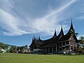
Galerie
Tribune Imam Bonjol 
Padang v roce 1859 
Masjid Sahara 
Řeka Arau 
Pláž v Padangu 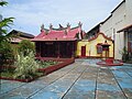
Čínská čtvrť
Reference
V tomto článku byl použit překlad textu z článku Padang na anglické Wikipedii.
Externí odkazy
 Obrázky, zvuky či videa k tématu Padang na Wikimedia Commons
  Padang na Wikivoyage
Média použitá na této stránce

Flag of Indonesia.svg
bendera Indonesia
bendera Indonesia
Indonesia location map.svg
Autor: Uwe Dedering, Licence: CC BY-SA 3.0
Location map of Indonesia.
Autor: Uwe Dedering, Licence: CC BY-SA 3.0
Location map of Indonesia.
Equirectangular projection. Stretched by 100.0%. Geographic limits of the map:
- N: 6.5° N
- S: -11.5° N
- W: 94.5° E
- E: 141.5° E


Flag of Thailand.svg
The national flag of Kingdom of Thailand; there are total of 3 colours:
The national flag of Kingdom of Thailand; there are total of 3 colours:
- Red represents the blood spilt to protect Thailand’s independence and often more simply described as representing the nation.
- White represents the religion of Buddhism, the predominant religion of the nation
- Blue represents the monarchy of the nation, which is recognised as the centre of Thai hearts.

Masjid Sahara, Padang Pasir.JPG
Autor: Rahmat Irfan Denas, Licence: CC BY-SA 3.0
Masjid Sahara, Padang Pasir
Autor: Rahmat Irfan Denas, Licence: CC BY-SA 3.0
Masjid Sahara, Padang Pasir

Local fishermen at Padang Beach.jpg
Autor: Fadillah Jafar, Licence: CC BY 3.0
Local fishermen at Padang Beach, West Sumatra, Indonesia
Autor: Fadillah Jafar, Licence: CC BY 3.0
Local fishermen at Padang Beach, West Sumatra, Indonesia

Klenteng See Hin Kiong.jpg
Autor: https://picasaweb.google.com/105238982219065575483, Licence: CC BY 3.0
See Hin Kiong Temple at Padang, West Sumatra, Indonesia
Autor: https://picasaweb.google.com/105238982219065575483, Licence: CC BY 3.0
See Hin Kiong Temple at Padang, West Sumatra, Indonesia

Tribune Imam Bonjol.JPG
Autor: Rahmat Irfan Denas, Licence: CC BY-SA 3.0
Tribune Imam Bonjol, Padang
Autor: Rahmat Irfan Denas, Licence: CC BY-SA 3.0
Tribune Imam Bonjol, Padang
Logo Padang.svg
Padang Coat of Arms. PD, Own work. This Indonesian Coat of Arms is free of copyrights (according to Indonesian Law: UU No. 19 Tahun 2002, Pasal 14 (b)).
Padang Coat of Arms. PD, Own work. This Indonesian Coat of Arms is free of copyrights (according to Indonesian Law: UU No. 19 Tahun 2002, Pasal 14 (b)).

Huis-van-een-hoofd,-Padangs.jpg
Huis van een hoofd Padangse Bovenlanden
Huis van een hoofd Padangse Bovenlanden
Padang dari Gunung Padang 2.JPG
Autor: Rahmat Irfan Denas, Licence: CC BY-SA 3.0
Downtown skyline of Padang from Gunung Padang hill
Autor: Rahmat Irfan Denas, Licence: CC BY-SA 3.0
Downtown skyline of Padang from Gunung Padang hill
Wikivoyage-Logo-v3-en.svg
Autor: AleXXw, Licence: CC BY-SA 3.0
Proposal for the new Wikivoyage logo by AleXXw, including an idea of Danapit. Set in the Gill Sans typeface.
Autor: AleXXw, Licence: CC BY-SA 3.0
Proposal for the new Wikivoyage logo by AleXXw, including an idea of Danapit. Set in the Gill Sans typeface.