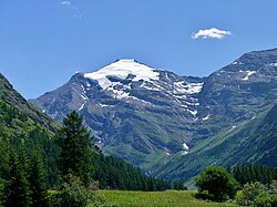
Pointe de Charbonnel
| Pointe de Charbonnel | |
|---|---|
 Pointe de Charbonnel | |
| Vrchol | 3 752 m n. m. |
| Prominence | 997 m |
| Izolace | 22,5 km |
| Poloha | |
| Světadíl | Evropa |
| Stát | |
| Pohoří | Grajské Alpy |
| Souřadnice | 45°16′51″ s. š., 7°3′20″ v. d. |
| Některá data mohou pocházet z datové položky. | |
Pointe de Charbonnel je hora ve francouzské části Grajských Alp. Leží na jihovýchodě Savojska, v blízkosti hranice s Itálií. Severozápadně od hory se nachází Národní park Vanoise.[1][2] Pointe de Charbonnel je s výškou 3 752 metrů třetí nejvyšší horou Grajských Alp[3] a náleží do první dvacítky nejvyšších hor Francie s prominencí vyšší než 500 metrů.
Reference
- ↑ Pointe de Charbonnel, France [online]. Peakbagger.com, 1987 [cit. 2022-04-16]. Dostupné online. (anglicky)
- ↑ France. Ostfildern, Stuttgart: Marco Polo 296 s. ISBN 978-3-8297--3705-0. S. 109.
- ↑ Graian Alps [online]. Peakbagger.com, 1987 [cit. 2022-04-16]. Dostupné online. (anglicky)
Externí odkazy
 Obrázky, zvuky či videa k tématu Pointe de Charbonnel na Wikimedia Commons
Média použitá na této stránce
This is a solid red equilateral triangle, which can symbolize or indicate many things, including the the symbol for fire in the books by Franz Bardon.
Autor: Florian Pépellin, Licence: CC BY-SA 4.0
Sight, in summer from the high Maurienne valley at Bessans, of the Pointe de Charbonnel mountain (3,752 meters high), at the end of Avérole valley, in Savoie, France.
Autor: Eric Gaba (Sting - fr:Sting), Licence: CC BY-SA 4.0
Blank physical map of metropolitan France for geo-location purpose.
Scale : 1:14 816 000 (accuracy : about 3,7 km) for the bathymetry. More maps of France, view → Commons Atlas of France.


