Povodí Konga

Povodí Konga je povodí řeky 1. řádu a je součástí úmoří Atlantského oceánu. S udávanou rozlohou povodí 4 014 500 km² (3 712 316 km²) se jedná o největší povodí Afriky.[1]
Geografie
Povodí Konga zahrnuje téměř celou Konžskou republiku, Konžskou demokratickou republiku, Středoafrickou republiku, jihozápadní Kamerun, severní Angolu a části Zambie, Burundi, Rwandy, Tanzanie a Gabonu. Rozprostírá se zhruba od 11,86° východní délky po 33,97° východní délky a od 9,21° severní šířky po 13,43° jižní šířky. Na východě sousedí s povodím Nilu, na jihu s povodím Zambezi a na severu s bezodtokým povodím Čadského jezera (řeky Šari). Zahrnuje celou Konžskou pánev, pohoří Kibara a z části plošinu Azande, pohoří Mitumba, Kundelungu, plošinu Lunda-Katanga a planinu Katanga.
Povodí Konga v afrických státech:[2]
| stát | rozloha [km2] | podíl [%] |
|---|---|---|
| Angola | 305 760 | 8,2 |
| Burundi | 18 728 | 0,51 |
| Kamerun | 85 300 | 2,3 |
| Středoafrická republika | 402 000 | 10,8 |
| Konžská demokratická republika | 2 307 800 | 62,15 |
| Gabon | 1 146 | 0,03 |
| Konžská republika | 248 400 | 6,7 |
| Rwanda | 382 | 0,01 |
| Tanzanie | 166 800 | 4,5 |
| Zambie | 176 600 | 4,8 |
| povodí Konga | 3 712 316 | 100,0 |
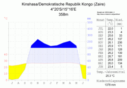
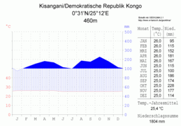
Klima
Velká část povodí má ekvatoriální a tropické monzunové podnebí.

 Borumba
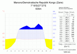 Manono
Vodní toky a plochy
Řeky
- Kongo, Aruwimi, Ebola, Chambeshi, Kasai, Kivu, Kwango, Lomami, Lualaba, Luapula, Lufira, Lukuga, Lulonga, Lulua, Luvua, Malagarasi, Malebo, Mbomou, Ruki, Ruzizi, Sanga, Sankuru, Ubangi, Uele.
Jezera
Přehrady
Vodopády
Odkazy
Reference
- ↑ J.P. vanden Bossche; G. M. BERNACSEK. Source Book for the Inland Fishery Resources of Africa, Volume 1. [s.l.]: Food and Agriculture Organization of the United Nations, 1990. Dostupné v archivu pořízeném z originálu dne 2016-04-25. ISBN 978-92-5-102983-1. S. 338–339.
- ↑ Congo-HYCOS [online]. [cit. 2023-04-15]. Dostupné v archivu pořízeném z originálu dne 2023-04-19.
Související články
Externí odkazy
 Obrázky, zvuky či videa k tématu povodí Konga na Wikimedia Commons
Média použitá na této stránce

Vlajka Angoly


The proportions of this flag are 3:2; however, there is no official definition for the correct proportions and also 5:3 is widely used.


Flag of Rwanda. The flag ratio is 2:3 with the stripes being 2:1:1. Colors are the following officially: Pantone 299 C 2X (blue), RAL 6029 (green), RAL 1023 (yellow) and RAL 1003 (golden yellow). (As of 03/08/2010, the only color used is the Pantone 299 C, which is from here. The rest of the colors are RAL shades from here.)


Autor: Hedwig in Washington, Licence: CC BY 2.5
climate chart in the format by Walther and Lieth, metric, °Celsisus and millimeters, made with Geoklima 2.1
-metrisch-deutsch.png)
Autor: Hedwig in Washington, Licence: CC BY 2.5
climate chart in the format by Walther and Lieth, metric, °Celsisus and millimeters, made with Geoklima 2.1
-metrisch-deutsch.png)
Autor: Hedwig in Washington, Licence: CC BY 2.5
climate chart in the format by Walther and Lieth, metric, °Celsisus and millimeters, made with Geoklima 2.1
-metrisch-deutsch.png)
Autor: Hedwig in Washington, Licence: CC BY 2.5
climate chart in the format by Walther and Lieth, metric, °Celsisus and millimeters, made with Geoklima 2.1
-metrisch-deutsch.png)
Autor: Hedwig in Washington, Licence: CC BY 2.5
climate chart in the format by Walther and Lieth, metric, °Celsisus and millimeters, made with Geoklima 2.1
Autor: Uwe Dedering, Licence: CC BY-SA 3.0
Relief location map of Democratic_Republic_of_the_Congo.
- Projection: Equirectangular projection, stretched by 100.0%.
- Geographic limits of the map:
- N: 6.0° N
- S: -14.0° N
- W: 11.0° E
- E: 32.0° E
- GMT projection: -JX19.473333333333333cd/18.546031746031744cd
- GMT region: -R11.0/-14.0/32.0/6.0r
- GMT region for grdcut: -R11.0/-14.0/32.0/6.0r
- Relief: SRTM30plus.
- Made with Natural Earth. Free vector and raster map data @ naturalearthdata.com.