Prefektura Čiba
| Prefektura Čiba | |
|---|---|
 | |
| Geografie | |
| Hlavní město | Čiba |
| Souřadnice | 35°36′ s. š., 140°7′ v. d. |
| Rozloha | 5 157,5 km² |
| Časové pásmo | UTC+09:00 japonský standardní čas |
| Geodata (OSM) | OSM, WMF |
| Obyvatelstvo | |
| Počet obyvatel | 6 279 002 (2021) |
| Hustota zalidnění | 1 217,5 obyv./km² |
| Správa regionu | |
| Stát | |
| Vznik | 15. června 1873 |
| Mezinárodní identifikace | |
| ISO 3166-2 | JP-12 |
| Oficiální web | www |
| Některá data mohou pocházet z datové položky. | |

Prefektura Čiba (japonsky: 千葉県, Čiba-ken) je jednou ze 47 prefektur Japonska. Nachází se v regionu Kantó na ostrově Honšú. Hlavním městem je Čiba.
Prefektura má rozlohu 5 156,61 km² a k 1. červnu 2013 měla 6 192 785 obyvatel.
Města
V prefektuře Čiba je 36 velkých měst (市, ši):
|
|
|
|
Externí odkazy
 Obrázky, zvuky či videa k tématu Prefektura Čiba na Wikimedia Commons
 - (anglicky) Oficiální stránky prefektury Čiba
Média použitá na této stránce
Emblem of Chiba Prefecture. The emblem was announced on December 28, 1909.
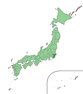
Large size map of Japan with Chiba highlighted, self made but originally based on a japanese mapbook.
Flag of Chiba Prefecture.
Autor: unknown, Licence: Copyrighted free use
Autor: Nanashinodensyaku, Licence: CC BY-SA 4.0
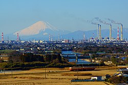
This is the distant view of the Keiyo industrial belt where Mt. Fuji was a background. Three chimneys in the right are Anegasaki LNG thermal power plant (3,600,000 kilowatts of output). The Highest chimney in the left of Anegasaki LNG thermal power plant is Idemitsu Chiba oil refinery (220,000 barrels of daily throughput). The chimney applied by red and white in the right is Mitsui Chemicals Chiba factory. Three chimneys in the left are Sumitomo Chemical Chiba factory. 33% of the ethylene consumed in Japan is made at Keiyo industrial belt.


