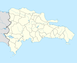
Puerto Plata
| Puerto Plata | |
|---|---|
(c) I, Martin Le Roy, CC BY 2.5 | |
| Poloha | |
| Souřadnice | 19°47′45″ s. š., 70°41′40″ z. d. |
| Nadmořská výška | 8 m n. m. |
| Stát | |
| Rozloha a obyvatelstvo | |
| Rozloha | 459,7 km² |
| Počet obyvatel | 440 508 (2021) |
| Hustota zalidnění | 958,2 obyv./km² |
| Správa | |
| Vznik | 1502 |
| Oficiální web | www |
| PSČ | 57000 |
| Některá data mohou pocházet z datové položky. | |
Puerto Plata (oficiálním názvem San Felipe de Puerto Plata) je přímořské město v Dominikánské republice, hlavní město provincie Puerto Plata a největší město severního pobřeží Dominikánské republiky. Bylo založeno již v roce 1496 (tedy pouhé 4 roky po objevení tohoto ostrova Kryštofem Kolumbem). Leží na úpatí hory Pico Isabel de Torres. V roce 2009 mělo město 153 791 obyvatel.[1] Jeho ekonomika je postavena především na turistice. Od 90. let je navštěvována zejména díky svým pěkným plážím.
Puerto Plata nabízí řadu dochovaných památek včetně španělské pevnosti Fuerte de San Felipe.
Ve městě Puerto Plata tragicky zemřel v roce 1998 rakouský zpěvák Falco.
Puerto Plata je oblíbená mezi českými turisty, a to zejména díky české komunitě.[2]
Reference
- ↑ Poblacion estimada y proyectada región provincia y municipio 2000-2010 [online]. Santo Domingo: Oficina Nacional de Estadistica ONE, 2009-09-17, rev. 2009-09-18 [cit. 2009-11-17]. Dostupné v archivu pořízeném dne 2009-12-19. (španělsky)
- ↑ Dominikánská republika bez cestovky. Jan a Monika z www.vitaminadominicana.com
Externí odkazy
 Obrázky, zvuky či videa k tématu Puerto Plata na Wikimedia Commons
 - http://www.puertoplata.com/
Média použitá na této stránce
The flag of the Dominican Republic has a centered white cross that extends to the edges. This emblem is similar to the flag design and shows a bible, a cross of gold and 6 Dominican flags. There are branches of olive and palm around the shield and above on the ribbon is the motto "Dios,Patria!, Libertad" ("God, Country, Freedom") and to amiable freedom. The blue is said to stand for liberty, red for the fire and blood of the independence struggle and the white cross symbolized that God has not forgotten his people. "Republica Dominicana". The Dominican flag was designed by Juan Pablo Duarte, father of the national Independence of Dominican Republic. The first dominican flag was sewn by a young lady named Concepción Bona, who lived across the street of El Baluarte, monument where the patriots gathered to fight for the independence, the night of February 27th, 1844. Concepción Bona was helped by her first cousin María de Jesús Pina.
The flag of the Dominican Republic has a centered white cross that extends to the edges. This emblem is similar to the flag design and shows a bible, a cross of gold and 6 Dominican flags. There are branches of olive and palm around the shield and above on the ribbon is the motto "Dios,Patria!, Libertad" ("God, Country, Freedom") and to amiable freedom. The blue is said to stand for liberty, red for the fire and blood of the independence struggle and the white cross symbolized that God has not forgotten his people. "Republica Dominicana". The Dominican flag was designed by Juan Pablo Duarte, father of the national Independence of Dominican Republic. The first dominican flag was sewn by a young lady named Concepción Bona, who lived across the street of El Baluarte, monument where the patriots gathered to fight for the independence, the night of February 27th, 1844. Concepción Bona was helped by her first cousin María de Jesús Pina.
Escudo de Puerto Plata (República Dominicana) para la wikipedia
Autor: Alexrk2, Licence: CC BY-SA 3.0
Location map Dominican Republic with Provinces, Equirectangular projection, N/S stretching 105 %. Geographic limits of the map:
(c) I, Martin Le Roy, CC BY 2.5
A view of Puerto Plata from the air looking towards Pico Isabel de Torres.
Autor: Alexrk2, Licence: CC BY-SA 3.0
Physical Location map Dominican Republic with Provinces, Equirectangular projection, N/S stretching 105 %. Geographic limits of the map:


