Rakouské Nizozemí
| Rakouské Nizozemí Österreichische Niederlande Pays-Bas Autrichiens Oostenrijkse Nederlanden Belgium Austriacum
| |||||||||||
geografie
| |||||||||||
nejdelší řeka: | |||||||||||
| obyvatelstvo | |||||||||||
| státní útvar | |||||||||||
měna: | kronenthaler | ||||||||||
| státní útvary a území | |||||||||||
| |||||||||||
Rakouské Nizozemí (německy Österreichische Niederlande) byl územně správní útvar Habsburské monarchie (náležící ke Svaté říši římské), který zbyl ze Španělského Nizozemí po Utrechtském míru (1713), jenž následoval po válce o španělské dědictví (1701–1714).
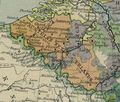
Mapy
Reference
V tomto článku byl použit překlad textu z článku Habsburg Netherlands na anglické Wikipedii.
Literatura
- WANNER, Michal. The Ostend Company as Phenomenon of International Politics in 1722–1731. Prague Papers on the History of International Relations. 2006, roč. 10, s. 29–63. Dostupné online [PDF]. ISBN 80-7308-161-X.
- WANNER, Michal. The Establishment of the General Company in Ostend in the Context of the Habsburg Maritime Plans 1714–1723. Prague Papers on the History of International Relations. 2007, roč. 11, s. 33–62. Dostupné online [PDF]. ISBN 978-80-7308-208-6.
Související články
Externí odkazy
 Obrázky, zvuky či videa k tématu Rakouské Nizozemí na Wikimedia Commons
Média použitá na této stránce
Autor: Ningyou., Licence: CC BY-SA 3.0
Flag with the cross of Burgundy (saltire). Also named Cross of Burgundy flag. It was used in the Catholic Monarchy and in its viceroyalties such as New Spain and Peru. It was also used by Spain as a military or king's prosonal flag. Used by the Carlist movement.
Autor: David Liuzzo, eagle by N3MO (re-uploaded by Dragovit), Licence: CC BY-SA 3.0
Banner of the Holy Roman Empire, double headed eagle without haloes (1400-1806)
Autor: David Liuzzo, eagle by N3MO, Licence: CC BY-SA 3.0
Banner of the Holy Roman Empire, double headed eagle with halos (1400-1806)
Autor:
Based on: File:Carte_montrant_les_Pays-Bas_autrichiens_et_leurs_provinces,_tels_qu'en_1789.svg: Sir Henry derivative work: Furfur – Based on: File:Carte montrant les Pays-Bas autrichiens et leurs provinces, tels qu'en 1789.svg:
Map showing Austrian Netherlands with provinces, as in 1789, in French. Based on : * Map : Faden, William "A map of the Austrian possessions in the Netherlands or Low Countries (1789), on David Rumsey Map collection; * Flandre rétrocédée : Delisle, Guillaume "Carte du Comté de Flandre (1704), on Gallica.bnf.fr., Licence: CC BY-SA 4.0Rakouské Nizozemí v roce 1789
Autor: self made from a low resolution raster version probably by Auseklis or Stijn_Calle, with some elements by Sodacan, Licence: CC BY-SA 3.0
Flag of the Austrian Low Countries
Autor:
- Europe_1789.svg: *Blank_map_of_Europe.svg: maix¿?
- derivative work: Alphathon
- derivative work: Alphathon
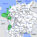
A map of the Austrian Netherlands within the Habsburg Monarchy, the Holy Roman Empire and Europe circa 1789.
Autor: Tento vektorový obrázek byl vytvořen programem Inkscape ., Licence: CC BY-SA 3.0
Coat of arms of the Austrian Netherlands.


