Saint-Santin
| Saint-Santin | |
|---|---|
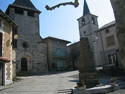
 Pohled na kostely v Saint-Santin-de-Maurs (vlevo) a Saint-Santin (vpravo) | |
| Poloha | |
| Souřadnice | 44°39′7″ s. š., 2°12′58″ v. d. |
| Nadmořská výška | 187–592 m n. m. |
| Stát | |
| Region | Midi-Pyrénées |
| Departement | Aveyron |
| Arrondissement | Villefranche-de-Rouergue |
| Kanton | Decazeville |
| Rozloha a obyvatelstvo | |
| Rozloha | 22,78 km² |
| Počet obyvatel | 554 (2009) |
| Hustota zalidnění | 24,06 obyv./km² obyv./km² |
| Správa | |
| Starosta | Raymond Bos (2008-2014) |
| PSČ | 12300 |
| Některá data mohou pocházet z datové položky. | |
Saint-Santin (Saint-Santin D'Aveyron) je francouzská obec, ležící v departmentu Aveyron v regionu Midi-Pyrénées.
Saint-Santin a Santin-Santin-de-Maurs
Obec velice těsně sousedí s obcí Saint-Santin-de-Maurs, která však leží v sousední departmentu Cantal. Prakticky tvoří jednu obec, která je však rozdělená právě departmenty. Obě mají vlastní obecní úřad se starostou, svou školu, svůj kostel. Společný je však pomník, který se nachází přesně na hranici a má nápis z obou stran. V obci stojí kostel 20 metrů vedle kostela sousední obce, mezi kterými prochází hranice departmentu.
Poloha
Obec má rozlohu 22,78 km². Nejvyšší bod je položený 592 m n. m. a nejnižší bod 187 m n. m.
Obyvatelstvo
V obci žije 554 obyvatel (rok 2009).
Související články
Externí odkazy
 Obrázky, zvuky či videa k tématu Saint-Santin na Wikimedia Commons
Média použitá na této stránce
Autor: Superbenjamin, Licence: CC BY-SA 4.0
Blank administrative map of France for geo-location purpose, with regions and departements distinguished. Approximate scale : 1:3,000,000
Autor: Dimanchin, Licence: CC BY-SA 3.0
vue de la place des deux Saint-Santin (Cantal et Aveyron) avec leurs deux églises
Autor:
|
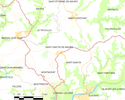
Map data (c) OpenStreetMap contributors, CC-BY-SA  • Shape files infrastructure: railway, highways, water: all originally by OpenStreetMap contributors. Status december 2011 *note: shown commune boundaries are from OSM dump May 2012; at that time about 90% complete |
Map commune FR insee code 15212.png


