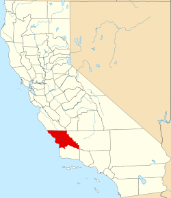
San Luis Obispo County
| San Luis Obispo County | |
|---|---|
 | |
| Geografie | |
| Hlavní město | San Luis Obispo |
| Status | okres |
| Souřadnice | 35°22′48″ s. š., 120°27′ z. d. |
| Rozloha | 9 364,2 km² |
| Časové pásmo | UTC-8/-7 |
| Geodata (OSM) | OSM, WMF |
| Obyvatelstvo | |
| Počet obyvatel | 269 637 (2010) |
| Hustota zalidnění | 28,8 obyv./km² |
| Správa regionu | |
| Nadřazený celek | Kalifornie |
| Vznik | 1850 |
| Oficiální web | www |
| Některá data mohou pocházet z datové položky. | |
San Luis Obispo County je okres ve státě Kalifornie v USA. K roku 2010 zde žilo 269 637 obyvatel.[1] Správním městem okresu je San Luis Obispo. Na jihu sousedí se Santa Barbara County a na severu s Monterey County. Sídlí zde rádio KWWV.
Reference
- ↑ Archivovaná kopie. quickfacts.census.gov [online]. [cit. 2012-01-08]. Dostupné v archivu pořízeném dne 2011-07-18.
Externí odkazy
 Obrázky, zvuky či videa k tématu San Luis Obispo County na Wikimedia Commons
 - Oficiální stránky
Média použitá na této stránce
This is a locator map showing San Luis Obispo County in California. For more information, see Commons:United States county locator maps.
Flag of California. This version is designed to accurately depict the standard print of the bear as well as adhere to the official flag code regarding the size, position and proportion of the bear, the colors of the flag, and the position and size of the star.
Autor: Jerry Kirkhart from Los Osos, Calif., Licence: CC BY 2.0
Point San Luis Lighthouse Photos that were taken on 9/1. Special thanks to Paul O'Connor, Kristi Balzer and Bob Canepafor this neat photo opportunity. I was glad to help set up the event too. Sunlight on the side spoke to me. Best seen with black boarder, just click on it once or press l if you have a mac.


