Seznam největších říší světa
Seznam největších říší (států) světa v celé jeho historii. Pořadí je podle jejich rozlohy (nad 1 milion km²).
Britské impérium (British Empire)

- 36 600 000 km² (1921)
- 485 000 000 obyvatel (1921)
- Jiří V. (1865–1936) – král Spojeného království a britských dominií a císař Indie
Mongolská říše (Монголын Эзэнт Гүрэн)

- 33 000 000 km² (1279)
- 100 000 000 (1279)
- Kublaj (1215–1294) – velký chán
Španělské impérium (Monarquía Española)

- 31 500 000 km² (1580–1640)
- 31 000 000 obyvatel (1580–1640)
- Filip II. Španělský (1556–1598) – španělský král
Ruské impérium (Российская империя)
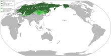
- 23 700 000 km² (1866)
- 181 537 800 obyvatel (1916)
- Mikuláš II. Alexandrovič (1868–1917) – ruský car
Svaz sovětských socialistických republik (Союз Советских Социалистических Республик)

- 22 402 220 km² (1991)
- 293 047 571 obyvatel (1991)
- Michail Sergejevič Gorbačov (1985–1991) – generální tajemník KSSS, předseda prezidia Nejvyššího sovětu a prezident
Ruská federace (Российская Федерация)

- 17 075 400 km²
- 143 200 000 obyvatel (2012)
- Vladimir Putin (1952) – prezident
Čínské císařství (中華帝國)
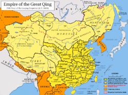
- 14 700 000 km² (1790)
- 383 100 000 obyvatel (1820)
- Ťia-čching (1799–1820) – syn Nebes
Umajjovský chalífát (بنو أمية)

- 13 000 000 km² (750)
- 34 000 000 obyvatel
- Marván II. (744–750) – chalífa
Kanada (Canada)

- 9 984 670 km²
- 32 547 200 obyvatel (2006)
- Mary Simon (1947) – generální guvernérka Kanady reprezentující krále Karla III.
Spojené státy americké (United States of America)
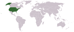
- 9 833 517 km²
- 340 970 393 obyvatel (2024)
- Donald Trump (1946) – prezident, šéf exekutivy federální vlády a vrchní velitel ozbrojených sil
Čínská lidová republika (中华人民共和国)
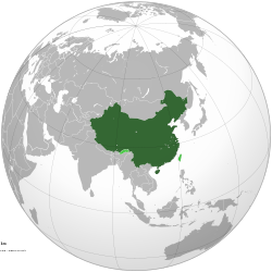
- 9 596 960 km²
- 1 312 897 300 obyvatel (2006)
- Si Ťin-pching (1953) – prezident a generální tajemník Ústředního výboru Komunistické strany Číny
Fátimovský chalífát (خلافة فاطمية)
Brazilská federativní republika (República Federativa do Brasil)

- 8 511 965 km²
- 191 908 598 obyvatel (2008)
- Luiz Inácio Lula da Silva (1945) – prezident a vrchní velitel ozbrojených sil
Australský svaz (Commonwealth of Australia)

- 7 747 400 km²
- 22 620 600 obyvatel (2011)
- Sam Mostyn (1965) – generální guvernérka Austrálie reprezentující krále Karla III.
Perská říše (هخامنشیان)

- 7 500 000 km² (490 př. n. l.)
- 42 000 000 obyvatel
- Dareios I. (522/521–486 př. n. l.) – šáhanšáh
Římská říše (Imperium Romanum)
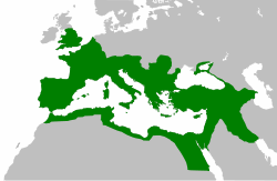
- 5 600 000 km² (117)
- Marcus Ulpius Traianus (53–117) – císař
- 90 milionů obyvatel za vlády císaře Trajána
Osmanská říše (دولت عالیه عثمانیه)

- 5 500 000 km² (1680)
- 35 350 000 obyvatel (1856)
- Mehmed III. – sultán
Makedonské království (Μακεδονικό βασίλειο)
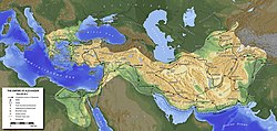
- 5 400 000 km² (330 př. n. l.)
- Alexandros Philippou Makedonon (356 př. n. l. – 323 př. n. l.) – král
Byzantská říše (Βασιλεία των Ρωμαίων)

- 4 500 000 km² (550)
- 34 000 000 obyvatel (300)
- Flavius Petrus Sabbatius Iustinianus (483–565) – císař
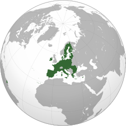
- 4 381 376 km²
- 507 742 653 (2013)
- Hlavní město: Brusel
- Donald Tusk – předseda Evropské rady
- Jean-Claude Juncker – předseda Evropské komise
Indická republika (भारत गणराज्य)

- 3 287 590 km²
- 1 210 000 000 (2011)
- Pranab Mukherdží (1935) – prezident a vrchní velitel ozbrojených sil
Mughalská říše (شاهان مغول)

Argentinská republika (República Argentina)
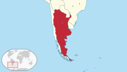
- 2 780 400 km²
- 40 091 359 obyvatel (2010)
- Javier Milei (1970) – prezident
Republika Kazachstán (Қазақстан Республикасы)

- 2 717 300 km²
- 16 594 000 obyvatel (2011)
- Kasym-Žomart Kemeluly Tokajev (1953) – prezident a vrchní velitel ozbrojených sil
Súdánská republika (جمهورية السودان) – do roku 2011

- 2 505 810 km²
- 40 187 486 obyvatel (2005)
- Abdal Fattáh Burhán (1944) – prezident
Alžírská demokratická a lidová republika (الجمهورية الجزائرية الديمقراطية الشعبية)

- 2 381 741 km²
- 33 769 668 obyvatel (2011)
- Abdal Madžíd Tabbúni (1945) – prezident a vrchní velitel ozbrojených sil
Demokratická republika Kongo (République démocratique du Congo)
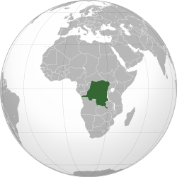
- 2 345 410 km²
- 68 692 542 obyvatel (2009)
- Félix Tshisekedi (1963) – prezident
Saúdskoarabské království (المملكة العربية السعودية)

- 2 149 690 km²
- 26 680 000 obyvatel (2011)
- Salmán bin Abd al-Azíz (1935) – král, předseda vlády v Radě ministrů a velitel Národní gardy
Incká říše (Tahuantinsuyo)
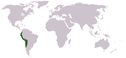
- cca. 1 900 000 km² (1527)
- 20 000 000 obyvatel (1517)
- Auqui Huallpa Túpac (? – 1533) – inka
Asyrská říše a Novoasyrská říše (ܐ ܫ ܘ ܪ)

- cca. 1 400 000 km² (671 př. n. l.)
- Aššur-ahhe-iddina (681 př. n. l. – 669 př. n. l.) – král
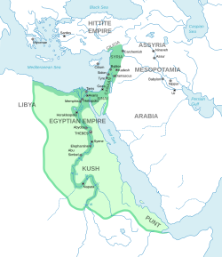
- cca. 1 000 000 km² (1500 př. n. l.)
- Thutmose III. (1479 př. n. l. – 1425 př. n. l.) – nisut-bitej
Média použitá na této stránce
Autor: Pryaltonian, Licence: CC BY-SA 3.0
Map of the Qing Dynasty in 1820, representing its stablized territory from 1790-1839. (Includes provincial boundaries and the boundaries of modern China for reference.) Provinces in yellow, military governorates and protectorates in light yellow, tributary states in orange.
Adapted from File:ROC_PRC_comparison_eng.jpg and information complied from:
- http://baike.baidu.com/view/5405.htm
- http://map.huhai.net/58-59.jpg
- http://www.sina7.com/jdwh/UploadFiles_6109/200709/20070918093610860.jpg
- File:China_and_Japan,_John_Nicaragua_Dower_(1844).jpg
- File:Carte_generale_de_l'Empire_Chinois_et_du_Japon_(1836).jpg
- File:Empire_Chinois,_Japon_(1832).jpg
- File:L'Empire_Chinois_et_du_Japon_(1833).jpg
- http://city.udn.com/3011/4192243?tpno=48&cate_no=0
- http://bbs.godeyes.cn/showtopic-371673.aspx
Own work. The Egyptian Empire.
Autor: TUBS
Location of XY (see filename) in the region.
Autor: Connormah
DRC, orthographic projection.
Autor: Generic Mapping Tools, Licence: CC BY-SA 3.0
Extent of the empire of Alexander the Great
Darstellungskarte des Mongolenreiches kurz vor dessen Auflösung (1295), selbst erstellt am 8. Aug. 2004; Public Domain
Diese Darstellungskarte zeigt das mongolische Gesamtreich Khubilai Khans zum Zeitpunkt seines Todes (1295).
(c) Arab League na projektu Wikipedie v jazyce angličtina, CC BY-SA 3.0
Fatimid Empire (910-1171). The island of Sicily is included though not colored red.
A map of the British Empire in 1921 when it was at its height, just before the Anglo-Irish Treaty of 1921.
(But 1921-1937 Ireland continued to have the same status as Canada, Newfoundland, the South African Union, Australia and New Zealand, that is to be part of the British Empire as a dominion)
Brasilian sijainti
Autor: Milenioscuro, Licence: CC BY-SA 3.0
Russian Empire.
Autor: Original uploader was Rudolf 1922 at sv.wikipedia, Licence: CC BY-SA 3.0
Indien, karta, Mogulriket 1690, egentillv.
Autor: Niusereset
Neoklis Kyriazis ("Nick"), Licence: GPLv3
Ancient egyptian name of Egypt: "Kemet" (sometimes incorectly "Ta Kemet")
created with coloured egyptian hieroglyphs by Neoklis Kyriazis ("Nick") and provided under the GNU GPL3 license
Autor: Původně soubor načetl Dodo na projektu Wikipedie v jazyce čeština, Licence: CC BY-SA 3.0
Rozsah Byzance za Justiniánovy vlády (kolem roku cs:550).
Autor: Users Albrecht, Arthur Wellesley, XGustaX on en.wikipedia, Licence: CC BY-SA 3.0
Map of the Spanish Empire from 295px.
Popis
Red
The Spanish Empire as it stood under the en:House of Bourbon, reaching its peak in the early 1790s. Includes the en:Viceroyalty of New Spain, en:Viceroyalty of Peru, en:Viceroyalty of La Plata, en:Viceroyalty of New Granada, en:Audiencia of Chile, en:Cuba, en:Puerto Rico, en:Santo Domingo, the Louisiana colony, the Nootka colony, the en:Philippines, the satellite en:Kingdom of Naples and en:Duchy of Parma, and various island groups.
Louisiana and New Orleans, which were never widely settled, were returned to France in 1800, the Nootka colony was abandoned in 1795; Spain ceded its claims to the en:Mississippi Territory to the United States in 1795 and en:Florida in 1819; en:New Spain became an independent en:Mexico in 1821.
Spanish settlement did not reach the south of Argentina and Chile until the early en:19th century. By 1824, all of Spain's South American colonies had become independent republics.
British economic rights in present-day en:Belize were established in the 18th century. The colony of en:British Honduras was not created until 1841, after the end of Spanish rule in the region. Most of Central America became independent in 1823 as the en:United Provinces of Central America. Cuba was granted independence and Puerto Rico was ceded to the United States after the en:Spanish-American War.
Pink
Regions of Spanish influence over various periods; disputed (i.e. Pacific Coast), unrecognized (i.e. en:Dutch Republic), or short-lived claims (i.e. Cambodia).
- en:Newfoundland (the Spanish Basque fishing fleet along with French and English fishermen controlled small parts of Newfoundland in the summer during the en:16th century. This control was shared each summer as politics were mostly ignored by the fishermen.)
- The Protestant Netherlands revolted against Philip II in 1568 and declared their independence as the United Provinces in 1581. After a long and bloody war this nation was finally granted official recognition by Spain and the international community in 1648.
- The part of the en:Amazon Basin shown here under Spanish influence was incorporated into Portuguese Brazil in the 17th and 18th centuries.
Lavender
Territories lost at or before the en:Peace of Utrecht in 1714. Spain lost Jamaica to England in the 1650s and Haiti to France in the en:17th century. Many smaller islands in the en:Bahamas and the en:Lesser Antilles were also settled by other Europeans during this period. Spain's territories in present-day France, such as en:Rousillon and the en:Franche-Comté, were conquered Louis XIV. Spain was stripped of her remaining European dominions in 1714. Spain reconquered some of her lost Italian possessions from the Austrians in the 18th century, placing Bourbon princes on the thrones of Parma, Naples, and Sicily. However, these were not incorporated again into the Spanish Crown.
Purple
Portuguese possessions ruled jointly under the Spanish sovereign, 1580-1640.
Brown
Autor:
- File:Global European Union.svg: S. Solberg J.
- odvozené dílo Tomeasy
The European Union in an orthographic projection with no borders between member states
Orthographic map of Algeria.
Autor: Ssolbergj, Licence: CC BY-SA 4.0
The People's Republic of China (green) and its claimed territory (lighter green).
Autor: Ssolbergj (talk), Licence: CC BY-SA 3.0
India. Area controlled by India in dark green; claimed but not controlled areas in light green.
Autor: Ssolbergj, Licence: CC BY-SA 3.0
The Union of Soviet Socialist Republics (Soviet Union)
Autor:
- Umayyad750ADloc.png: Gabagool
- derivative work: باسم
خارطة تُظهر المساحة التي امتدَّت عليها الدولة الأُمويَّة في أقصى اتساعها وذُروة قوَّتها، حوالي سنة 750م. (الرسم مبني بشكلٍ جُزئيّ على كتاب "أطلس تاريخ العالم" (2007) - العالم ما بين سنتيّ 500 و750م، الخارطة.)
Map of the Assyrian Empire
Autor: User:Dinamik, Licence: CC BY-SA 3.0
Location of Sudan 1956-2011. Territories controlled by the Arab Republic of Egypt are highlighted.
Autor: Angelus, Licence: CC BY-SA 3.0
Map of the Roman Empire at its height, under Trajan.
Autor: TUBS
Location of XY (see filename) in the region.
Historic map of the Achaemenid Empire


