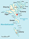
Seznam ostrovů Faerských ostrovů
Faerské ostrovy tvoří 18 ostrovů s rozlohou nad 0,75 km², 11 ostrovů nad 0,75 hektaru a okolo 750 malých skalnatých ostrůvků. Zde je seznam ostrovů a ostrůvků.
Tabulka ostrovů
Tabulka ostrůvků
| Ostrůvek | Rozloha (km²) | Nejvyšší bod (m) | Nejbližší ostrov |
|---|---|---|---|
| Tindhólmur | 0,65 | 262 | Vágar |
| Mykineshólmur | 0,45 | 104 | Mykines |
| Trøllhøvdi | 0,19 | 123 | Sandoy |
| Gáshólmur | 0,10 | 65 | Vágar |
| Tjaldavíkshólmur | 0,075 | cca 20 | Suðuroy |
| Sumbiarhólmur | 0,07 | cca 10 | Suðuroy |
| Lopranshólmur | 0,034 | cca 35 | Suðuroy |
| Kirkjubøhólmur | 0,02 | 2 | Streymoy |
| Hovshólmur | 0,017 | cca 5 | Suðuroy |
| Hoyvíkshólmur | 0,008 | cca 5 | Streymoy |
| Baglhólmur | 0,008 | cca 5 | Suðuroy |
Galerie
- Streymoy
- Eysturoy
- Vágar
- Suðuroy
- Sandoy
- Borðoy
- Viðoy
- Kunoy
- Kalsoy
- Svínoy
- Fugloy
- Nólsoy
- Mykines
- Skúvoy
- Hestur
- Stóra Dímun
- Koltur
- Lítla Dímun
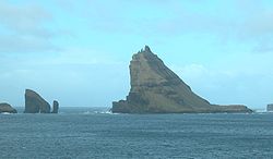
- Tindhólmur
- Tjaldavíkshólmur
Poznámky
- ↑ v roce 2007
Související články
- Seznam ostrovů Atlantského oceánu
- Seznam ostrovů Norského moře
- Seznam ostrovů Dánska
- Seznam ostrovů Grónska
Externí odkazy
 Obrázky, zvuky či videa k tématu Seznam ostrovů Faerských ostrovů na Wikimedia Commons
 - Fotografie ostrůvků
Média použitá na této stránce
Autor: NikNaks, Licence: CC BY-SA 4.0
Cropped version of Blank map of Europe.svg, coloured blue.
Autor: Erik Christensen, Licence: CC BY-SA 3.0
Mountain Sornfelli - 749 m. Streymoy, Faroe Islands
Autor: Erik Christensen, Porkeri (Contact at the Danish Wikipedia), Licence: CC BY-SA 3.0
Coast of Svínoy, Faroe Islands.
Autor: Erik Christensen, Porkeri, Licence: CC BY-SA 3.0
The island of Mykines, Faroe Islands. Seen from the east (Sørvágur) in October.
Autor: Erik Christensen, Porkeri (Contact at the Danish Wikipedia), Licence: CC BY-SA 3.0
Fugloy, Faroe Islands.
Autor: User:Erik Christensen, Licence: CC BY-SA 3.0
Sørvágsvatn med Trælanípa i baggrunden
Autor: Erik Christensen, Porkeri (Contact at the Danish Wikipedia), Licence: CC BY-SA 3.0
Skúvoy, Faroe Islands (view from Skarvanes)
Autor: Erik Christensen, Porkeri (Contact at the Danish Wikipedia), Licence: CC BY-SA 3.0
On the way to Skarvanes on Sandoy, Faroe Islands. The island in the background is Stóra Dímun (and Suðuroy at the horizon)
Autor: Erik Christensen, Porkeri (Contact at the Danish Wikipedia), Licence: CC BY-SA 3.0
The island of Hestur, Faroe Islands, as seen from Sandoy
Autor: User:Erik, Licence: CC BY-SA 3.0
Tjaldavíkshólmur, Suðuroy, Faroe Islands.
Autor: http://da.wikipedia.org/wiki/Bruger:Erik_Christensen, Licence: CC BY-SA 3.0
Beinisvørð and westcoast of Suðuroy, Faroe Islands
Autor: Erik Christensen, Porkeri (Contact at the Danish Wikipedia), Licence: CC BY-SA 3.0
Kunoy, Faroe Islands.
(c) Arne List, CC BY-SA 3.0
Karte der Färöer mit den Namen aller Inseln und der Städte.
Autor: Erik Christensen, Porkeri (Contact at the Danish Wikipedia), Licence: CC BY-SA 3.0
The island of Lítla Dímun, Faroe Islands.
Autor: Erik Christensen, Porkeri (Contact at the Danish Wikipedia), Licence: CC BY-SA 3.0
Slættaratindur (882m) on Eysturoy, Faroe Islands. The highest mountain of the country.
Autor: Erik Christensen, Porkeri (Contact at the Danish Wikipedia), Licence: CC BY-SA 3.0
Cape Enniberg on Viðoy, Faroe Islands.
Autor: Erik Christensen, Porkeri (Contact at the Danish Wikipedia), Licence: CC BY-SA 3.0
Koltur, Faroe Islands


