Seznam sopek v Africe
Toto je seznam sopek v Africe.
Seznam
| Název | Forma | Výška (m) | Souřadnice | Poslední erupce |
|---|---|---|---|---|
| Atakor | Vulkanické pole | 2 918 | 23°19′48″ s. š., 5°49′48″ v. d. | 8000 př. n. l. |
| In Ezzane | Vulkanické pole | ? | 23° s. š., 10°49′48″ v. d. | ? |
| Manzaz | Vulkanické pole | 1 672 | 23°55′12″ s. š., 5°49′48″ v. d. | Neolit |
| Nemours-Nedroma | Vulkanické pole | 444 | 35°4′12″ s. š., 2° z. d. | Před 2,1 milionem let |
| Tafna Beni Saf | Vulkanické pole | 480 | 35°16′48″ s. š., 1°27′ z. d. | Před 820 tisíci lety |
| Tahalra | Vulkanické pole | 1 467 | 22°40′12″ s. š., 5° v. d. | Holocén |

Atakor 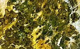
Manzaz
| Název | Forma | Výška (m) | Souřadnice | Poslední erupce |
|---|---|---|---|---|
| Abeki | ??? | 2 450 | 21°6′ s. š., 17° v. d. | ??? |
| Emi Koussi | Štítová sopka | 3 415 | 19°48′ s. š., 18°31′48″ v. d. | Holocén |
| Oyoye | Vulkanický komplex | 2 230 | 20°29′24″ s. š., 17°19′12″ v. d. | ??? |
| Tarso Toh | Vulkanické pole | 2 000 | 21°19′48″ s. š., 16°19′48″ v. d. | Holocén |
| Tarso Toussidé | Stratovulkán | 3 265 | 21°1′48″ s. š., 16°27′ v. d. | Holocén |
| Tarso Voon | Stratovulkán | 3 100 | 20°55′12″ s. š., 17°16′48″ v. d. | Holocén |
| Tieroko | ??? | 2 910 | 20°24′ s. š., 17°30′36″ v. d. | ??? |
| Tarso Yega | Stratovulkán | 2 972 | 20°21′36″ s. š., 17°14′24″ v. d. | ??? |
Tarso Toh 

Tarso Yega
| Název | Forma | Výška (m) | Souřadnice | Poslední erupce |
|---|---|---|---|---|
| Ardoukôba | Riftová zóna | 298 | 11°34′48″ s. š., 42°28′12″ v. d. | 1978 |
| Boina | Fumarolické pole | 300 | 11°15′ s. š., 41°49′48″ v. d. | Pleistocén |
| Garbes | Fumarolické pole | 1 000 | 11°25′12″ s. š., 42°12′ v. d. | Pleistocén |
| Tiho | Fumarolické pole | 500 | 11°31′48″ s. š., 42°3′ v. d. | ??? |
| Název | Forma | Výška (m) | Souřadnice | Poslední erupce |
|---|---|---|---|---|
| Alid | Stratovulkán | 910 | 18°52′48″ s. š., 39°55′12″ v. d. | Holocén |
| Asseb | Vulkanické pole | 910 | 12°51′ s. š., 42°25′48″ v. d. | Holocén |
| Dubbi | Stratovulkán | 987 | 13°34′48″ s. š., 41°48′36″ v. d. | 1861 |
| Gufa | Vulkanické pole | 600 | 12°33′ s. š., 42°31′48″ v. d. | Holocén |
| Jalua | Stratovulkán | 713 | 15°2′24″ s. š., 39°49′12″ v. d. | ??? |
| Moussa Ali | Stratovulkán | 2 028 | 12°28′12″ s. š., 42°24′ v. d. | Holocén |
| Nabro | Stratovulkán | 2 218 | 13°22′12″ s. š., 41°42′ v. d. | 2011 |
Alid 
Asseb 
Nabro
| Název | Forma | Výška (m) | Souřadnice | Poslední erupce |
|---|---|---|---|---|
| Pilanesberg | Vulkanický komplex | 1 687 | 25°14′24″ j. š., 27°4′48″ v. d. | Pleistocén |
| Marion | Štítová sopka | 1 230 | 46°54′ j. š., 37°45′ v. d. | 2008 |
| Ostrov prince Edvarda | Štítová sopka | 672 | 46°37′48″ j. š., 37°57′ v. d. | Holocén |
| Název | Forma | Výška (m) | Souřadnice | Poslední erupce |
|---|---|---|---|---|
| Kamerunská hora | Stratovulkán | 4 095 | 4°12′ s. š., 9°10′12″ v. d. | 2000 |
| Enep | ? | ? | 6°18′ s. š., 10°30′ v. d. | ? |
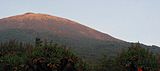
| Manengouba | Stratovulkán | 2 411 | 5°1′48″ s. š., 9°49′48″ v. d. | Holocén |
| Ngaoundere | Vulkanické pole | ? | 7°15′ s. š., 13°40′12″ v. d. | Holocén |
| Oku | Vulkanické pole | 3 011 | 6°15′ s. š., 10°30′ v. d. | (?) 1986 |
| Tchabal Nganha | Stratovulkán | 1 927 | 7°21′ s. š., 14° v. d. | ? |
| Tombel Graben | ? | 500 | 4°45′ s. š., 9°40′12″ v. d. | Holocén |

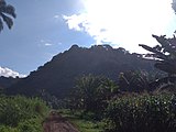
Manengouba
| Název | Forma | Výška (m) | Souřadnice | Poslední erupce |
|---|---|---|---|---|
| Brava | Stratovulkán | 976 | 14°51′ s. š., 24°43′12″ z. d. | Holocén |
| Pico do Fogo | Stratovulkán | 2 829 | 14°57′ s. š., 24°21′ z. d. | 2015 |
| São Vicente | Stratovulkán | 744 | 16°51′ s. š., 24°58′12″ z. d. | Holocén |
Elmenteita (v popředí) 

Ol Doinyo Eburru (v pozadí) 
Suswa
| Název | Forma | Výška (m) | Souřadnice | Poslední erupce |
|---|---|---|---|---|
| La Grille | Štítová sopka | 1 087 | 11°28′12″ j. š., 43°19′48″ v. d. | Holocén |
| Karthala | Štítová sopka | 2 361 | 11°45′ j. š., 43°22′48″ v. d. | 2007 |
| Název | Forma | Výška (m) | Souřadnice | Poslední erupce |
|---|---|---|---|---|
| May-Ya-Moto | Fumarolické pole | 2 000 | 0°55′48″ j. š., 29°19′48″ v. d. | ??? |
| Nyamuragira | Štítová sopka | 3 058 | 1°24′36″ j. š., 29°12′ v. d. | 2021 |
| Nyiragongo | Stratovulkán | 3 470 | 1°31′12″ j. š., 29°15′ v. d. | 2021 |
| Tshibinda | Vulkanické pole | 1 460 | 2°19′12″ j. š., 28°45′ v. d. | Holocén |
| Bisoke | Stratovulkán | 3 711 | 1°28′12″ j. š., 29°29′24″ v. d. | 1957 |
 (c) MONUSCO/Neil Wetmore, CC BY-SA 2.0
Bisoke
| Název | Forma | Výška (m) | Souřadnice | Poslední erupce |
|---|---|---|---|---|
| Gharján | Vulkanické pole | 850 | 32° s. š., 13°15′ v. d. | Pleistocén |
| Charúdž | Vulkanické pole | 1 200 | 27°15′ s. š., 17°30′ v. d. | Před 2 310 lety (± 810 let) |
| Waw an Namus | Kaldera | 547 | 24°33′ s. š., 17°27′36″ v. d. | Holocén |

Waw an Namus
| Název | Forma | Výška (m) | Souřadnice | Poslední erupce |
|---|---|---|---|---|
| Ambre-Bobaomby | Vulkanické pole | 1 475 | 12°36′ j. š., 49°9′ v. d. | Holocén |
| Ankaizina | Pyroklastické kužele | 2 878 | 14°18′ j. š., 48°40′12″ v. d. | Holocén |
| Ankaratra | Vulkanické pole | 2 644 | 19°24′ j. š., 47°12′ v. d. | Holocén |
| Itasy | Vulkanické pole | 1 800 | 19° j. š., 46°46′12″ v. d. | 6050 př. n. l. |
| Nosy Be | Vulkanické pole | 214 | 13°19′12″ j. š., 48°28′48″ v. d. | Holocén |
| Název | Forma | Výška (m) | Souřadnice | Poslední erupce |
|---|---|---|---|---|
| Commerson Crater | Kaldera | 2 310 | 21°12′36″ j. š., 55°37′48″ v. d. | ??? |
| Piton de la Fournaise | Štítová sopka | 2 632 | 21°13′48″ j. š., 55°42′36″ v. d. | 2021 |
| Piton des Neiges | Štítová sopka | 3 069 | 21°3′ j. š., 55°17′24″ v. d. | Pleistocén |

Commerson Crater 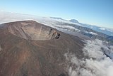
| Název | Forma | Výška (m) | Souřadnice | Poslední erupce |
|---|---|---|---|---|
| San Carlos | Štítová sopka | 2 261 | 3°21′ s. š., 8°31′12″ v. d. | Holocén |
| San Joaquin | Štítová sopka | 2 009 | 3°21′ s. š., 8°37′48″ v. d. | Holocén |
| Pico Basilé | Štítová sopka | 3 011 | 3°34′48″ s. š., 8°45′ v. d. | 1923 |
| Název | Forma | Výška (m) | Souřadnice | Poslední erupce |
|---|---|---|---|---|
| Karisimbi | Stratovulkán | 4 507 | 1°30′ j. š., 29°27′ v. d. | Holocén |
| Muhabura | Stratovulkán | 4 127 | 1°22′48″ j. š., 29°40′12″ v. d. | Holocén |
| Bisoke | Stratovulkán | 3 711 | 1°28′12″ j. š., 29°29′24″ v. d. | Holocén |

Muhabura Bisoke
| Název | Forma | Výška (m) | Souřadnice | Poslední erupce |
|---|---|---|---|---|
| Pico de São Tomé | Štítová sopka | 2 024 | 0°16′12″ s. š., 6°32′24″ v. d. | Pleistocén |
| Název | Forma | Výška (m) | Souřadnice | Poslední erupce |
|---|---|---|---|---|
| Bayuda | Vulkanické pole | 670 | 18°19′48″ s. š., 32°45′ v. d. | 850 |
| Jebel Marra | Vulkanické pole | 3 042 | 12°57′ s. š., 24°16′12″ v. d. | 1500 př. n. l. |
| Jebel Umm Arafieb | Vulkanické pole | ??? | 18°10′12″ s. š., 33°49′48″ v. d. | Holocén |
| Tagabo | Vulkanické pole | ??? | 14°34′12″ s. š., 25°51′ v. d. | Holocén |
| Meidob | Vulkanické pole | 2 000 | 15°19′12″ s. š., 26°28′12″ v. d. | 2500 př. n. l. |
Bayuda  (c) Hammy07, CC BY-SA 3.0
Jebel Marra 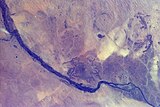
Jebel Umm Arafieb 
Gelai  (c) Yoni Lerner, CC BY 2.0

| Název | Forma | Výška (m) | Souřadnice | Poslední erupce |
|---|---|---|---|---|
| Bufumbira | Vulkanické pole | 2 440 | 1°13′48″ j. š., 29°43′12″ v. d. | Holocén |
| Bunyaruguru (sopka) | Maary | 1 554 | 0°12′ j. š., 30°4′48″ v. d. | Holocén |
| Elgon | Štítová sopka | 4 321 | 1°6′ j. š., 34°30′ v. d. | ??? |
| Fort Portal | Tufové kužele | 1 524 | 0°42′ s. š., 30°15′ v. d. | Holocén |
| Katunga | Tufový kužel | 1 707 | 0°28′12″ j. š., 30°10′48″ v. d. | Holocén |
| Katwe-Kikorongo | Tufový kužel | 1 067 | 0°4′48″ j. š., 29°55′12″ v. d. | Holocén |
| Kyatwa | Tufové kužele | 1 430 | 0°27′ s. š., 30°15′ v. d. | Holocén |
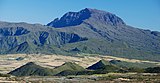
| Muhabura | Stratovulkán | 4 127 | 1°22′48″ j. š., 29°40′12″ v. d. | Holocén |
Muhabura (vpravo)
Odkazy
Reference
Externí odkazy
 Obrázky, zvuky či videa k tématu Seznam sopek v Africe na Wikimedia Commons
Média použitá na této stránce


Vlajka Etiopie

Used color: National flag | South African Government and Pantone Color Picker
| zelená | rendered as RGB 0 119 73 | Pantone 3415 C |
| žlutá | rendered as RGB 255 184 28 | Pantone 1235 C |
| červená | rendered as RGB 224 60 49 | Pantone 179 C |
| modrá | rendered as RGB 0 20 137 | Pantone Reflex Blue C |
| bílá | rendered as RGB 255 255 255 | |
| černá | rendered as RGB 0 0 0 |


Flag of Rwanda. The flag ratio is 2:3 with the stripes being 2:1:1. Colors are the following officially: Pantone 299 C 2X (blue), RAL 6029 (green), RAL 1023 (yellow) and RAL 1003 (golden yellow). (As of 03/08/2010, the only color used is the Pantone 299 C, which is from here. The rest of the colors are RAL shades from here.)


Autor: Kathryn Combes 2008, exec officer, Soysambu Conservancy Ltd, Licence: CC BY-SA 3.0
view from Eburru to Elementeita Badlands

Autor: A.Savin, Licence: FAL
Elementární síra vykrystalizovaná z horkých podzemních pramenů sopky Dallol v Danakilské prolákliné Afarská pánev, Ethiopie.

Autor: Clem23, Licence: CC BY-SA 3.0
Mount Lengai seen from Lake Natron, Northern Tanzania


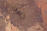
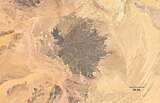
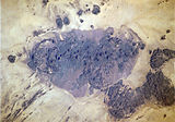
The broad Emi Koussi volcano is a shield volcano located in northern Chad, at the south-eastern end of the Tibesti Range. The dark volcanic rocks of the volcano provide a sharp contrast to the underlying tan and light brown sandstone exposed to the west, south, and east (image lower left, lower right, and upper right). This astronaut photograph highlights the entire volcanic structure. At 3,415 meters above sea level, Emi Koussi is the highest summit of Africa's Sahara region. The summit includes three calderas formed by powerful eruptions. Two older and overlapping calderas form a depression approximately 12 kilometres by 15 kilometres in area bounded by a distinct rim (image centre). The youngest and smallest caldera, Era Kohor, formed as a result of eruptive activity within the past 2 million years.

Autor: Junior Verges, Licence: CC BY-SA 4.0
Cette image présente le Mont Manengouba , situé à Nkongsamba, dans la région du Littoral .

The dark area at in the center above the bend in the Nile River in NE Sudan is the Jebel Umm Arafieb volcanic field, also known as Jebel Umm Marafieb. Located in the Bayuda Desert NE of the capital city of Khartoum, this volcanic field consists of a low-angle shield volcano formed of several overlapping aa lava flows erupted from a vent now capped by a spatter cone.

Autor: Hgmichna, Licence: CC BY 3.0
Menengai Crater, Kenya - view from the caldera edge. More of the edge is visible near the horizon.

Tousside, Tibesti Mountains, Chad
- The Tibesti Mountains in northwestern Chad consist of rugged volcanic peaks, many impressive craters, and hot springs. Near the center of the photograph is Tousside Peak, which rises more than 10 710 feet (3265 meters) above sea level, the westernmost volcano of this high mountain range. The peak is almost centered within the black shape that has tentacle-shaped lava flows extending down the western flank. The volcano’s base measures approximately 55 miles (90 kilometers) in diameter. The light brownish area surrounding the peak shows a distinctive radial drainage pattern that is quite common for stratovolcanoes as the terrain falls away from the main peak. The depression southeast of the volcano measures approximately 5 miles (8 kilometers) in diameter and 3300 feet (1000 meters) in depth. The white base is caused by an accumulation of carbonate salts, creating this soda lake of Tibesti. With the exception of small vents that emit gasses and a few hot springs that continue to deposit minerals at the surface of the crater floor, little volcanic activity presently occurs in this region.
Image number STS052-73-14

Satellite image of South Africa's Marion Island.
Original NASA caption, for a version similarly cropped to show just Marion Island:
"A dusting of ice graced the summit of Marion Island in early May 2009 as waves breaking against the island’s shore formed a broken perimeter of white. Like its smaller neighbor, Prince Edward Island, Marion Island is volcanic, rising above the waves of the Indian Ocean off the southern coast of Africa. Prince Edward and Marion are part of South Africa’s Western Cape Province. (Both islands appear in the large image.)
"The Advanced Land Imager (ALI) on NASA’s Earth Observing-1 (EO-1) satellite acquired this natural-color image on May 5, 2009. Sunlight illuminates the northern slopes of the volcanic island, leaving southern slopes in shadow. More than 100 small, reddish volcanic cones dot the island, some of the most conspicuous in the north and east. The island reaches its highest elevation, 1,230 meters (4,040 feet), near the center. Vegetation is generally sparse on Marion Island. Lichens live near the summit, and mosses and ferns grow elsewhere on the boggy surface, but trees don’t grow on the island.
"Occurring at the juncture between the African Continental Plate and the Antarctic Plate, Marion Island has been volcanically active for 18,000 years. The first historical eruption was recorded in November 1980 when researchers recorded two new volcanic hills and three lava flows. Researchers observed another small eruption in 2004.
"Besides volcanic cones, Marion Island is home to Marion Base, part of the South African National Antarctic Programme. Focusing on biological, environmental, and meteorological research, the base is situated on the island’s northeastern coast."
Autor: StFr, Licence: CC0
The volcanic cone of Waw an-Namus, sometimes spelled Wau-en-Namus, as seen from the margin of the caldera. The lakes are visible at the margins, and the black colour of the sand.

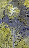
Tarso Voon volcano in Chad. Satellite view.

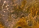
The dark-colored area in the center of this Space Shuttle view is the alkaline Meidob volcanic field in western Sudan. This broad volcanic field covers an area of 5000 sq km with nearly 700 Pliocene-to-Holocene vents. The margins of the field are dominated by basaltic scoria cones and associated lava flows, but trachytic-phonolitic lava domes, tuff rings, and maars, concentrated along the central E-W-trending axis of the volcanic field, are among the youngest features. The latest dated eruptions took place about 5000 years ago.

This NASA Landsat image shows small scoria cones and lava flows of the Manzaz volcanic field in the Hoggar (Ahaggar) volcanic district of Algeria. The volcanic field covers an area of 1500 sq km, overlying Precambrian metamorphic and plutonic rocks of the Tuareg shield. Many cones are breached, and the dominantly basaltic and basanitic volcanic products are rich in peridotite and pyroxenite xenoliths and megacrysts. The youngest volcanoes rest on Neolithic terraces and are of Holocene age.

The long chain of pyroclastic cones and lava flows extending East-West across this Landsat image is the Assab volcanic field near the Red Sea coast in southern Eritrea.
- This spectacular range of basaltic cinder cones and associated lava flows covers a 55 x 90 km area, and flows reached the Red Sea along a broad front.
- The vents of the Assab volcanic field were constructed along a broad E-W-trending line that extends to the coastal city of Assab, out of view to right.

Autor: Pouyot, Licence: CC BY-SA 4.0
Cratère du Piton de la Fournaise vu d'hélicoptère

Autor: Clem23, Licence: CC BY-SA 3.0
Mount Gelai seen from the southern tip of Lake Natron, Northern Tanzania

Autor: Serge Moons, Licence: CC BY-SA 3.0
Volcan Pico Basilé sur l 'ïle de Bioko , avec un panache nuageux

Satellite image of South Africa's Prince Edward Island.


(c) Hammy07, CC BY-SA 3.0
Inner and outer crater, Deriba Crater, Jebel Marra, Darfur, Sudan.

Autor: User:Amakuru, Licence: CC BY-SA 3.0
Mount Gahinga and Mount Muhabura, on the Rwanda/Uganda border

Bora-Bericcio volcanic complex.

The elongated Alid volcano, which sits on the axis of the Danakil spreading center, is seen here from the west. Most of the flanks of the volcano in this view are composed of dipping rhyolitic lava flows; the light-colored area along the right skyline is rhyolitic pumice. The summit of the volcano is elongated in an E-W direction and contains a 1 x 1.5 km wide, 100-m-deep crater at the western end. Vast lava fields originating from fissure vents in the Alid graben extend to the NW and SE of the volcano. Vigorous fumarolic activity continues at Alid.

Nabro Volcano Before 2011 Eruption

Autor: Linus Wolf, Licence: CC0
The Ahaggar, also known as the Hoggar, a volcanic mountain range in the central Sahara.
The image is averaged from 58 Landsat 8-scenes, provided by NASA. Bands 4, 3, 2 and 8 were combined into an RGB image. Panchromatic sharpening, conversion to radiance, weighted averaging, and rescaling to extrema of the scenes was done in R with the package RStoolbox. JPEG-encoded with Guetzli.
Images acquired in the range 18. července 2013 – 2. března 2021, each at mean 10:05, range 10:04–10:07. The sun position range: azimuth 86°–155°, average 133°; elevation 38°–69°, average 52°.
Resolution: 15m.
Projection: UTM 31 N, WGS84.
Center: 769590, 2574870.
From WRS-2 Path 192 Row 044.

Homa Mountain in Kenya

The central caldera of Suswa, the southernmost caldera of the Kenya rift, contains an unusual 5-km-wide circular graben that isolates a tilted island block of caldera-floor lava flows. Construction of an early shield volcano was followed by eruption of voluminous pumice flows and lava flows that accompanied formation of the caldera. The latest eruptions of Suswa have originated from parasitic vents that have issued still-unvegetated lava flows that may be only a century or so old. North is to the top in this NASA Landsat image.

Autor: A.Savin, Licence: FAL
View to Ale Bagu – landscape between Lake Afdera and Erta Ale volcano, Afar Region, Ethiopia

Autor: No machine-readable author provided. Amakuru assumed (based on copyright claims)., Licence: CC BY-SA 3.0
Mount Karisimbi, Rwanda

Autor: BBCLCD, Licence: CC BY-SA 4.0
Krater des erloschenen Vulkans Commerson auf 2320 m Höhe.

Autor: filippo_jean, Licence: CC BY-SA 2.0
Erta Ale is an active shield volcano located in the Afar Region of northeastern Ethiopia, within the Danakil Desert. It is the most active volcano in Ethiopia.


(c) MONUSCO/Neil Wetmore, CC BY-SA 2.0
An aerial view of the towering volcanic peak of Mount Nyiragongo.

A vertical aerial photo of the Quaternary Fentale volcanic complex, lying along the main Ethiopian rift zone, shows its prominent summit caldera and lava flows forming its flanks. The 3 x 4 km caldera with steep-sided walls up to 500 m high is elongated perpendicular to the direction of the regional fissures of the Ethiopian Rift. Note the recent rhyolitic obsidian lava flow to the NE (upper right) marked with curved flow ridges. The dark lava flow on the caldera floor was erupted in 1820.


Autor: Aldo Bien, Licence: CC BY-SA 3.0
Fogo island aerial shot taken from an Airbus cockpit

Flag of São Tomé and Príncipe

Piton des neiges

Autor: Ondřej Hanousek, Licence: CC BY-SA 4.0
Vulkán Afdera viditelný od jezera Afdera

The Bayuda volcanic field is located near the center of the Bayuda desert of NE Sudan. The numerous small cinder cones that trend horizontally across the center of the volcanic field in this Space Shuttle image were erupted along a WNW-trending line. Lava flows, one of which was erupted about 1100 years ago, are visible in this image, but about 10% of the vents are explosion craters. Bayuda was constructed over Precambrian and Paleozoic granitic rocks, which form the darker areas at the lower right.

Autor: alKomor.com, Licence: CC BY-SA 2.0
Karthala volcano, Grande Comore


Small cinder cones and lava flows of the Tarso Tôh volcanic field can be seen in the large darker-brownish area at the center of this NASA Landsat image. This Pleistocene-to-Holocene volcanic field in the Tibesti Range of Chad covers a 30 x 80 km area and contains 150 scoria cones and two maars. Basaltic lava flows at Tarso Tôh were erupted over a basement of Precambrian schists and Paleozoic sandstones. The black lava flows at the very bottom-center are distal lava flows from Tarso Toussidé volcano.