Sheridan County (Kansas)
| Sheridan County | |
|---|---|
 | |
| Geografie | |
| Hlavní město | Hoxie |
| Status | okres |
| Souřadnice | 39°21′ s. š., 100°25′59″ z. d. |
| Rozloha | 2 322 km² |
| Geodata (OSM) | OSM, WMF |
| Obyvatelstvo | |
| Počet obyvatel | 2 556 (2010) |
| Hustota zalidnění | 1,1 obyv./km² |
| Správa regionu | |
| Stát | |
| Nadřazený celek | Kansas |
| Vznik | 1873 |
| Oficiální web | www |
| Některá data mohou pocházet z datové položky. | |
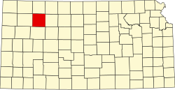
Sheridan County je okres ve státě Kansas v USA. K roku 2010 zde žilo 2 556 obyvatel. Správním městem okresu je Hoxie. Celková rozloha okresu činí 2 322 km².
Externí odkazy
 Obrázky, zvuky či videa k tématu Sheridan County na Wikimedia Commons
Média použitá na této stránce
This is a locator map showing Sheridan County in Kansas. For more information, see Commons:United States county locator maps.
Autor: SMU Central University Libraries, Licence: No restrictions
Title: No. 56. The Buffalo Hunters' Home at Sheridan, Kas.
Creator: Benecke, Robert, 1835-1903
Date: 1873
Part Of: //digitalcollections.smu.edu/cdm/search/collection/wes/searchterm/Vault Ag1982.0086/mode/exact/
Place: Sheridan, Kansas
Physical Description: 1 photographic print: albumen; 19.25 x 25 cm. on 20 x 27.5 cm. mount
File: vault_ag1982_0086_56_opt.jpg
Rights: Please cite DeGolyer Library, Southern Methodist University when using this file. A high-resolution version of this file may be obtained for a fee. For details see the https://sites.smu.edu/cul/degolyer/research/permissions/ web page. For other information, contact degolyer@smu.edu.
For more information, see: http://digitalcollections.smu.edu/cdm/ref/collection/wes/id/523


