Storegga


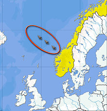
Storegga (norsky: velká hrana) je označení kontinentálního svahu v Norském moři před norským pobřežím na jižní části Vøring-Plateau. Pod kontinentálním svahem se v průběhu tisíciletí vytvořila gigantická masa štěrku a kamení. Jedná se s délkou 800 km a objemem 5608 km³ o jednu ze světově největších akumulací po sesuvech na kontinentálních svazích.[1]
Sesuvy jsou uváděny do souvislosti s pokročilou destabilizací kontinentálního svahu hydráty plynů, především hydrátem metanu. Velký sesuv na kontinentálním svahu může vést k vlně tsunami v Norském a Severním moři.
Podle výzkumů došlo k masivnímu sesuvu svahu asi před 8175 až 8120 lety, což mělo za následek obří tsunami, která na Shetlandech dosahovala přes 20 m a na pobřeží severní Británie okolo 3–6 m.[2] Jelikož ve stejném období došlo k výraznému úbytku mezolitického obyvatelstva na britských ostrovech, předpokládá se, že to souvisí právě s tsunami ze Storeggy, která měla vliv na zdecimování tamějšího osídlení.[2][3] Tato megatsunami měla pravděpodobně také podíl na zaplavení Doggerlandu, což byla v mezolitu lidmi osídlené krajina rozkládající se mezi Británií a kontinentální Evropou.[3]
Reference
V tomto článku byl použit překlad textu z článku Storrega na německé Wikipedii.
- ↑ M. Latif: Klimawandel und Klimadynamik. Ulmer Verlag, 2009, s. 180 f.
- ↑ a b SHARROCKS, Patrick D., HILL, Jon. Evaluating the impact of the Storegga tsunami on Mesolithic communities in Northumberland. Journal of Quarternary Science. 2023, s. 1–15. Dostupné online. ISSN 0267-8179. DOI 10.1002/jqs.3586. (anglicky)
- ↑ a b Stanislav Mihulka. Paleotsunami Storegga v mezolitu zřejmě zdecimovalo obyvatele Británie. Osel.cz [online]. 2024-01-09 [cit. 2024-01-12]. Dostupné online.
Externí odkazy
 Obrázky, zvuky či videa k tématu Storegga na Wikimedia Commons
 - Storegga Slide Tsunami
- Storegga Landslide & Tsunami.mov
Média použitá na této stránce
Position of the Storegga Slide (west of Norway). the yellow numbers give the height of the tsunami wave as tsunamite s recently studied by researchers. This is a megatsunami which- around 8150 years ago - has spread to hundreds of kilometers following the collapse of a piece of shelf. Source of yellow data. see also (in French): museum presentation by the Belgian "A tsunami in Belgium?"
Autor: Lamiot, Licence: CC BY-SA 3.0
Storegga Slides are considered to be amongst the largest known landslides. They occurred under water, at the edge of Norway's continental shelf (Storegga is Norwegian for "the Great Edge"), in the Norwegian Sea, 100 km (62 mi) north-west of the Møre coast, causing a very large tsunami in the North Atlantic Ocean. This collapse involved an estimated 290 km (180 mi) length of coastal shelf, with a total volume of 3,500 km3 (840 cu mi) of debris.[1] This would be the equivalent volume to an area the size of Iceland covered to a depth of 34 m (112 ft).

