Susquehanna
| Susquehanna | |
|---|---|
 řeka v Marylandu | |
| Základní informace | |
| Délka toku | 715 km |
| Plocha povodí | 71 000 km² |
| Průměrný průtok | 963 m³/s |
| Světadíl | Severní Amerika |
| Pramen | |
| Otsego 42°42′2″ s. š., 74°55′10″ z. d. | |
| Ústí | |
| Chesapeake 39°32′35″ s. š., 76°4′32″ z. d. 0 m n. m. | |
| Protéká | |
| Úmoří, povodí | |
| Atlantský oceán | |
 | |
| Geodata | |
| OpenStreetMap | OSM, WMF |
| Některá data mohou pocházet z datové položky. | |
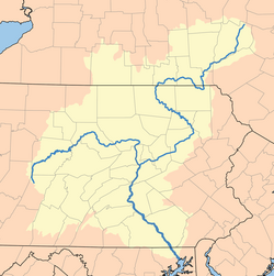
Susquehanna (anglicky Susquehanna River) je řeka ve státech New York, Pensylvánie a Maryland na východě USA. Je 715 km dlouhá. Povodí má rozlohu 71 000 km².
Průběh toku
Hlavní severní zdrojnice odtéká z jezera Otsego v Cooperstownu ve státě New York v pohoří Catskill. Teče na západ až jihozápad. Přibírá řeku Unadilla v Sidney a Chenango v centru Binghamtonu. Na předměstí Athens jižně od Waverly poté, co překročí hranici Pensylvánie přibírá Chemung ze severozápadu a mění směr v pravém úhlu mezi Sayre and Towandou. Jihozápadně od Scrantonu přijímá Lackawannu, otáčí se na jihozápad a protéká okolo měst Wilkes-Barre, Nanticoke, Berwick, Bloomsburg a Danville v Appalačském pohoří a na planině Piedmont, přičemž vytváří peřeje. Severně od Northumberlandu nad Sunbury se severní zdrojnice spojuje s vedlejší západní zdrojnicí. Společný tok ústí v Marylandu do zátoky Chesapeake Atlantského oceánu.
Vodní stav
Nejvyšších vodních stavů dosahuje na jaře, zatímco od září do listopadu je úroveň hladiny nejnižší. Průměrný roční průtok vody u města Harrisburg činí 963 m³/s. Zamrzá na konci prosince a rozmrzá na konci března až na začátku dubna.
Využití
Na řece bylo vybudováno mnoho přehradních nádrží. Vodní doprava je možná na dolním toku.
Literatura
- V tomto článku byly použity informace z Velké sovětské encyklopedie, heslo „Саскуэханна“.
Externí odkazy
 Obrázky, zvuky či videa k tématu Susquehanna na Wikimedia Commons
Média použitá na této stránce
Autor: I, Karl Musser, created it, Licence: CC BY-SA 2.5
This is a map of the Susquehanna River Watershed.
Autor: Derek Ramsey, Licence: CC BY-SA 2.5
Picture of the Susquehanna_River from the Susquehanna State Park in Maryland somewhere along Stafford Road. The picture was taken looking NE. It was directly adjacent to an old two story house (plus a basement) with white siding and a stone foundation.
This picture of the Susquehanna River includes the a number of the delapitated piers for the former bridge between w:Lapidum and w:Port Deposit. This Port Deposit Bridge, put into service in 1818, was the earliest bridge crossing of the Susquehanna River in Maryland. The wooden covered bridge was constructed just north of Port Deposit between 1817 and 1818 and had to be rebuilt after a span burned in 1823. It was reconstructed and remained in service until 1857. The piers were in relatively good shape in the 60's, but have been so badly damaged by high water periodically released from the Conowingo dam just upstream that they are now piles of stone in the river. Williamborg 14:04, 13 May 2007 (UTC) The old two story house (plus a basement) with white siding and a stone foundation which the uploader refers to was the former toll house for the bridge. Skål - Williamborg 14:08, 13 May 2007 (UTC)
The far shoreline in the image is not the left bank of the river, but Wood Island. Wood Island is only 0.25 miles from the near (right) river bank, and the entire river is about 0.81 miles wide at this point, so this image is not indicative of the width of the river. --J Clear (talk) 01:14, 25 January 2010 (UTC)


