Teritorium Michigan
| Teritorium Michigan Michigan Territory
| |||||||||
geografie
| |||||||||
| státní útvar | |||||||||
organizované začleněné území Spojených států amerických | |||||||||
vznik: | |||||||||
zánik: | |||||||||
| státní útvary a území | |||||||||
| |||||||||
Teritorium Michigan (anglicky Michigan Territory) bylo organizované začleněné území Spojených států amerických, které existovalo od roku 1805 do roku 1837, kdy byl finální rozsah teritoria přijat do Unie jako stát Michigan. Teritorium vzniklo na základě zákona Enabling Act v roce 1805.
Dějiny
Území bylo postupně zpřístupňováno Evropanům od konce 17. století. Mělo význam hlavně jako místo kontroly obchodu s kožešinami. Od roku 1774 bylo součástí provincie Quebec a od roku 1796 trvalou součástí Spojených státu. První okres, Wayne County byl založen již 15. srpna 1796. Ekonomicky významnou stavbou bylo otevření kanálu The Erie Canal v roce 1825, který umožnil osadníkům z Nové Anglie a New Yorku dosáhnout Michigan po vodě od Albany a Buffala. Michigan vedl dokonce v roce 1835 válku s Ohiem o území Toleda. Tohoto území se nakonec Michigan vzdal výměnou za západní sekci horního poloostrova Michiganu. Při svém vstupu do Unie měl Michigan počet obyvatel 200 000, což bylo mnohem víc, než požadovaná hranice z Northwest Ordinance, která činila 60 000 obyvatel.
Obyvatelstvo teritoria
Sčítáni obyvatel v teritoriu nezahrnovalo Indiány, kteří na základě Ústavy Spojených státu nebyli zdaněni "Indians not taxed" (Článek I, odsek. 2). V roce 1800 mělo Severozápadní teritorium 43 365 obyvatel. V smyslu Northwest Ordinance territorium muže požádat o členstvo, když počet obyvatel převýší 60 000.
| Rok | Počet obyvatel |
|---|---|
| 1810 | 4,762 |
| 1820 | 8,896 |
| 1830 | 31,639 |
| 1834 | 87,273 |
| 1840 | 212,267 |
Reference
V tomto článku byl použit překlad textu z článku Michigan territory na anglické Wikipedii.
Externí odkazy
 Obrázky, zvuky či videa k tématu Teritorium Michigan na Wikimedia Commons
 - Bay County Map History: Michigan Territory to Present
Média použitá na této stránce
Digital reproduction of the Star Spangled Banner Flag, the 15-star and 15-stripe U.S. garrison flag which flew over Fort McHenry following the Battle of Baltimore in the War of 1812. Seeing the flag during the battle, and again the following morning, inspired Francis Scott Key's song The Star-Spangled Banner, now the U.S. national anthem. During the battle a smaller "storm flag" was flown; it was replaced by this larger flag early the next morning, which is the flag Key saw then. This larger flag is now displayed at the National Museum of American History in Washington, D.C. For several decades it remained in the family of Fort McHenry's commanding officer, before being given to the Smithsonian in 1912. The family cut pieces out of the flag from time to time as gifts.
The original flag was 42 feet long and 30 feet high, with each stripe being about two feet, and the stars being about two feet in diameter. It was made by Mary Young Pickersgill and her assistants. More info on the original dimensions here. The stars seem to mostly point to the side, except for one (the bottom right) which points down. One star has been cut out of the actual flag, so I'm guessing that originally pointed to the side as well (Fort McHenry flies a flag (File:Ft mchenry 15starflag.jpg) with a similar star pattern, but it looks like they are all to the side, and the other dimensions look similar to a modern flag). I guesstimated other dimensions and star positions based on File:Star-Spangled-Banner-1908-1919.jpg; the union (blue area) looks to be about 19 feet wide. The star rows look to be evenly distributed; i.e. the distance between the top/bottom edges and the center of a star row looks to be about the same as the distance between two (centers of) rows. Not so left-to-right; they are pretty close to the right edge and even closer to the hoist side. Also available here, page 12.Autor: Jengod, Licence: CC BY 2.0
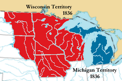
Map of Michigan Territory in 1836 following the detachment of Wisconsin Territory Based on a public domain U.S. government map.


