Torresův průliv
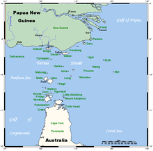
Torresův průliv je mořský průliv široký asi 150 km oddělující Austrálii od Nové Guineje a spojující Korálové s Arafurským mořem. Průliv je pojmenován po mořeplavci Torresovi, který průliv objevil v roce 1606.
Externí odkazy
 Obrázky, zvuky či videa k tématu Torresův průliv na Wikimedia Commons
Média použitá na této stránce
Pacific Ocean map, tagged in English
(c) Kelisi from en.wikipedia.org, CC BY-SA 3.0
A map of the Torres Strait Islands. I have endeavoured to use native names wherever I could find them. If you can suggest ways in which this map could be made more up to date, don't hesitate to leave me a message to that effect.
This map's source is here, with the uploader's modifications, and the GMT homepage says that the tools are released under the GNU General Public License.

