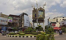
Udon Thani
| Udon Thani อุดรธานี | |
|---|---|
 | |
| Poloha | |
| Souřadnice | 17°25′ s. š., 102°45′ v. d. |
| Stát | |
| provincie | Udon Thani |
| Rozloha a obyvatelstvo | |
| Rozloha | 47 km² |
| Počet obyvatel | 153 329 (2012) |
| Hustota zalidnění | 3 262,3 obyv./km² |
| Správa | |
| PSČ | 41 280 |
| Některá data mohou pocházet z datové položky. | |
Udon Thani (thajsky: อุดรธานี, výslovnost: [ʔudɔːn tʰaːniː]) je hlavní město stejnojmenné provincie a jedno ze čtyř velkých měst v thajském regionu Isán.
Poloha
Udon Thani leží přibližně 560 kilometrů od Bangkoku. Je to důležité obchodní centrum a brána do Laosu, severního Vietnamu a jižní Číny. Ve městě žije 399 535 obyvatel.
Galerie
Náměstí Pavilion - (c) User:Pattapol, CC BY 3.0
Mezinárodní letiště
Reference
V tomto článku byl použit překlad textu z článku Udon Thani na anglické Wikipedii.
Externí odkazy
 Obrázky, zvuky či videa k tématu Udon Thani na Wikimedia Commons
Média použitá na této stránce
The national flag of Kingdom of Thailand; there are total of 3 colours:
- Red represents the blood spilt to protect Thailand’s independence and often more simply described as representing the nation.
- White represents the religion of Buddhism, the predominant religion of the nation
- Blue represents the monarchy of the nation, which is recognised as the centre of Thai hearts.
(c) User:Pattapol, CC BY 3.0
Terminal building, Udon Thani International Airport
Autor: Stefan Fussan , Licence: CC BY-SA 3.0
Pavilion at the Athipbodi Road in Udon Thani
Autor: Stefan Fussan , Licence: CC BY-SA 3.0
Clock Roundabout, Udon Thani, Thailand
Autor: Stefan Fussan , Licence: CC BY-SA 3.0
The City Pillar Shrine, Udon Thani, Thailand


