Velké Otročí jezero
| Velké Otročí jezero | |
|---|---|
 Velké Otročí jezero z vesmíru | |
| Poloha | |
| Světadíl | Severní Amerika |
| Stát | |
| Teritorium | Severozápadní teritoria |
 Velké Otročí jezero | |
| Zeměpisné souřadnice | 61°40′ s. š., 114° z. d. |
| Rozměry | |
| Rozloha | 27 200 km²[1] |
| Délka | 480 km[1] |
| Šířka | 109 km[1] |
| Objem | 1 580 km³[1] |
| Povodí | 971 000[1] km² |
| Max. hloubka | 614[1] m |
| Ostatní | |
| Typ | ledovcovo-tektonický |
| Nadm. výška | 156[1] m n. m. |
| Pobřeží | 3 057 km[1] |
| Přítok vody | Otročí řeka, Hay |
| Odtok vody | Mackenzie |
| Sídla | Yellowknife, Fort Providence, Hay River, Dawson Landing, Fort Resolution, Reliance |
| Některá data mohou pocházet z datové položky. | |
Velké Otročí jezero (anglicky Great Slave Lake) je jezero na území Severozápadních teritorií v Kanadě. Kotlina jezera je ledovcovo-tektonického původu. Má rozlohu 27 200 km². Dosahuje maximální hloubky 614 m a je nejhlubším jezerem v Severní Americe. Leží v nadmořské výšce 156 m.
Název
Název jezera se je odvozen od jména indiánského kmene Slavey (někdy i Slave), který v oblasti kolem jezera sídlí spolu s dalšími kmeny - (Čipevajané, Tlicho, Yellowknives, Sahtu). Všechny tyto kmeny jsou příslušníky národa Dené rozptýleného v obrovské oblasti Severozápadních teritorií, v krajině nekonečných lesů, jezer a řek. Jméno "Slavey" pochází od Kríů, kteří tak pohrdlivě nazývali své severní sousedy.
Geografie
Západní břehy jsou nízké, pokryté jehličnatým lesem. Východní a severní jsou pahorkaté a převážně holé. Ve východní části jezera jsou stovky ostrovů. Do jezera ústí Otročí řeka, Hay aj. a odtéká řeka Mackenzie. Jezero zamrzá na konci října a rozmrzá v červnu. Je zde rozvinutý rybolov a místní lodní doprava.
Demografie
Na severním pobřeží leží město Yellowknife a mnohá další naleziště zlata.
Galerie
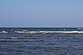 Velké Otročí jezero u Hay River
 Pláž u Hay River
 Mělký záliv
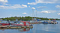 Čluny v Yellowknife
 Hausbóty v Yellowknife
 Odtok řeky Mackenzie z jezera
Odkazy
Reference
Literatura
- V tomto článku byly použity informace z Velké sovětské encyklopedie, heslo „Большое невольничье озеро“.
Externí odkazy
 Obrázky, zvuky či videa k tématu Velké Otročí jezero na Wikimedia Commons
 - (anglicky) Fotografie Velkého Otročího jezera Archivováno 18. 7. 2012 na Wayback Machine.
Média použitá na této stránce
.svg)
Flag of Canada introduced in 1965, using Pantone colors. This design replaced the Canadian Red Ensign design.

Autor: Daniel Case, Licence: CC BY-SA 3.0
Boats (and some docks) in Yellowknife Bay of Great Slave Lake

Autor: Ymblanter, Licence: CC BY-SA 4.0
Great Slave Lake beach in Hay River, on Vale Island
.jpg)
Autor: Susan Drury from Watson Lake, Canada, Licence: CC BY 2.0
There are many house boats on Great Slave Lake in Yellowknife, NWT

GSLAKE
Autor: Nzeemin, Licence: CC BY-SA 3.0
Relief map of Canada.
- Projection: Lambert Conformal Conic Projection
- lon0 = -27°
- lat0 = 69°
- lat1 = 51°
- lat2 = 45°
- Projection/coords for GMT:
-Jl-95/49/49/77/1:29350000 -R-121.36/38.29/-11.5/63.0r
.jpg)
The Mackenzie River—North America’s largest northward flowing river—drains a basin that spans one-fifth of Canada’s total land area. Each year, the Mackenzie delivers about 325 cubic kilometers (78 cubic miles) of fresh water to the Arctic Ocean. That’s about 7 percent of the fresh water that flows into the entire Arctic Ocean each year.
Researchers continue to discover how the addition of fresh water affects the Arctic Ocean. For example, at the delta of the Mackenzie, river outflow has been shown to alter the ice in the Beaufort Sea.
But where did that water get its start? These images show a segment of the Mackenzie River about 1,600 kilometers (1,000 miles) upstream from the delta, where the river originates at Great Slave Lake in Canada’s Northwest Territories. The Operational Land Imager (OLI) on Landsat 8 captured natural-color views of the lake and river on May 13, 2015. According to satellite-based estimates, that’s about the date in springtime when ice on the lake begins to melt. The close-up view (second image) shows pieces of ice already adrift in the river. The lake is typically ice-free by the beginning of June and stays that way until mid- to late-December. However, conditions on the lake can vary dramatically from year to year.
Great Slave Lake is one of the largest freshwater lakes in the world, with a surface area of about 28,600 square kilometers (11,000 square miles). It’s a deep lake, too, with an average depth of 88 meters (290 feet). Because of its size, the lake can store plenty of heat during the open water season—the period when the lake is ice-free.
This subarctic environment is dotted with numerous wetlands and lakes. Just north of Great Slave Lake, the tree line meets a band of patchy, discontinuous permafrost that stretches across northern Canada. Forested areas around the lake have been known to burn during the fire season. A burn scar on the lake’s western shore is still visible in this image.These true- and false-color images of central Canada show the Great Slave Lake in the Northwest Territories (top) and Lake Athabasca to the southeast. Lake Athabasca straddles the border between Alberta (west) and Saskatchewan (east). A fire (red dot) is burning in Alberta, and the snow capped Rocky Mountains cut through southwest Alberta at bottom left. In the false-color image, vegetation is green, water is dark blue, and ice (or snow) is light blue. -NASA
.jpg)
Autor: Alan Sim from Cambridge Bay, Canada, Licence: CC BY-SA 2.0
Hay River beach 05