Vicinální dráhy v Belgii
Vicinální dráhy (francouzsky Tramways vicinaux, nizozemsky Buurtspoorwegen) byla síť regionálních drah na pomezí tramvaje a železnice v Belgii. Největšího rozkvětu síť dosáhla v 1. polovině 20. století. Jelikož byl systém elektrifikován jen z poloviny, byly zde užívány rovněž dieselové a parní lokomotivy. Tato síť byla provozována společností Nationale Maatschappij Van Buurtspoorwegen – NMVB (nizozemsky) neboli Société Nationale des Chemins de fer Vicinaux – SNCV (francouzsky).
Historie
V roce 1875 byla v Belgii přijata nová legislativa, která povolovala výstavbu venkovských tratí. V důsledku toho vznikla společnost NMVB/SNCV, která tyto tratě provozovala. První trať byla otevřena v roce 1885 mezi městy Ostende a Nieuwpoort. V roce 1894 začala tratě elektrifikovat a první elektrifikovaná trať se nacházela mezi Bruselem a obcí Kleine Hut. V období 2. světové války se počet spojů významně zvýšil a zároveň délka tratí dosáhla svého maxima. V 60. letech však docházelo k postupnému úpadku a od 70. let byly v provozu jen některé městské tratě jako součást městské hromadné dopravy. Nejdelší zachovalý úsek je „Kusttram“, tramvajová dráha dlouhá 68 km procházející kolem belgického pobřeží.
Tratě

Tratě se nacházely ve městech i mimo ně. Mimo města byly většinou stavěny podél silnic a přepravovaly jak cestující, tak i dřevo a zemědělské produkty. Síť byla od začátku budována s rozchodem koleje 1000 mm. V okolí Antverp byly tratě stavěny s rozchodem 1067 mm. V roce 1921 však byla zahájena přestavba těchto tratí na rozchod 1000 mm. Od počátku byly tratě elektrifikovány na 500 V ss. Největšího rozmachu zažily tratě neelektrifikované v roce 1925 – 3938 km, elektrifikované pak v roce 1950 – 1528 km a síť jako taková v roce 1945 – 4811 km.
Mapy

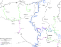
Limburská provincie
Jih Namurské provincie
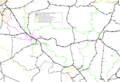
Západ henegavské provincie

Oblast Borinage v Henegavské provincii
Oblast Centre v Henegavské provincii

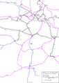
Oblast Charleroi v Henegavské provincii
Galerie

Zastávka trati
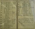
Jízdní řád z roku 1933

Motorový vůz přestavěný na nákladní

Nákladní vůz
Externí odkazy
Média použitá na této stránce

Autor: Smiley.toerist, Licence: CC BY-SA 3.0
Vicinal railway net work in the Borinage (Hainaut) area.

Autor: Smiley.toerist, Licence: CC BY-SA 3.0
Map off the vicinal railways in the province off Limburg.
- Purple lines = electrified lines in 1954
- Brown lines = idem, but outside the province
- Green lines = non-electrified lines in 1950
- Yellow lines = idem, but outside the province
- Blue lines = Some lines off the Liege citytram
- Black lines = Railways (normal gauge)

Autor: Smiley.toerist, Licence: CC BY-SA 3.0
Map off the vicinal railways in the province off Hainaut (Westside).
- Purple lines = electrified lines in 1940
- Brown lines = electrified SNCV lines outside province
- Green lines = non-electrified lines in 1940
- Yellow lines = idem, but outside the province
- Black lines = Railways (normal gauge)
Autor: Smiley.toerist, Licence: CC BY-SA 3.0
The SNCV vicinal logo placed on all trams.

Autor: Smiley.toerist, Licence: CC BY-SA 3.0
Map of the vicinal railways in the province of Brabant.
- Purple lines = electrified lines in 1953
- Brown lines = idem, but outside the province
- Green lines = non-electrified lines in 1950
- Yellow lines = idem, but outside the province
- Blue lines = Some lines of the Brussels citytram
- Black lines = Railways (normal gauge)

Autor: Smiley.toerist, Licence: CC BY-SA 3.0
SNCV motortram rebuild as tractor for the goods traffic.

Autor: Smiley.toerist, Licence: CC BY-SA 3.0
Map of the SNCV vicinal railway and SNCB railways, at the maximum extend in the Charleroi region. Around 1956.

Autor: Smiley.toerist, Licence: CC BY-SA 3.0
Map off the vicinal railways in the province off Namur.
- Purple lines = electrified lines (maximum extent)
- Brown lines = idem, but outside the province
- Green lines = non-electrified lines in 1940
- Yellow lines = idem, but outside the province
- Blue lines = Rivers
- Black lines = Railways (normal gauge)

Carte postale ancienne éditée par Henri Georges, éditeur à Bruxelles N°33
KNOCKE-ZOUTE - Station du Tram

Autor: Smiley.toerist, Licence: CC BY-SA 3.0
Map off the vicinal railways in the province of Liège.
- Purple lines = electrified lines in 1951
- Brown lines = idem, but outside the province
- Green lines = non-electrified lines in 1940
- Yellow lines = idem, but outside the province
- Blue lines = Some lines off the Liege and Verviers citytram
- Black lines = Railways (normal gauge)
.jpg)
Autor: Georges Colet, Licence: CC BY-SA 3.0
Keywords : SNCV, vicinal railways, rail, tram, goods wagon, van, type HF, Heysel, Brussels, Belgium

Autor: Smiley.toerist, Licence: CC BY-SA 3.0
Map of the vicinal railways in the South of the province of Namur.

Autor: Smiley.toerist, Licence: CC BY-SA 3.0
Vicinal railway SNCV network of the "Centre" regio in Hainaut province.

Autor: Smiley.toerist, Licence: CC BY-SA 3.0
Map of the vicinal railways in the Belgian province of Luxemburg.

Autor: Smiley.toerist, Licence: CC BY-SA 3.0
Map off the vicinal railways in the province of West Flandres.
- Purple lines = electrified lines in 1950
- Brown lines = Coastline in service
- Green lines = non-electrified lines in 1940
- Yellow lines = idem, but outside the province
- Blue lines = Temporary lines during the first world war
- Black lines = Railways (normal gauge)

Autor: Smiley.toerist, Licence: CC BY-SA 3.0
Map off the vicinal railways in the province off East Flandres.
- Purple lines = electrified lines in 1954
- Brown lines = idem, but outside the province
- Green lines = non-electrified lines in 1940
- Yellow lines = idem, but outside the province
- Blue lines = Some lines off the Gent citytram
- Black lines = Railways (normal gauge)
Autor: Draceane, Licence: CC BY 3.0
Graf ukazující délku belgických tratí provozovaných společností NMVB/SNCV v průběhu 20. století

Postal lines in 1933 in Belgium. From Belgian railway timetable.

Autor: Smiley.toerist, Licence: CC BY-SA 3.0
Map off the vicinal railways in the province off Antwerp.
- Purple lines = electrified lines in 1952
- Brown lines = idem, but outside the province
- Green lines = non-electrified lines in 1940
- Yellow lines = idem, but outside the province