Wald im Pinzgau
| Wald im Pinzgau | |
|---|---|
 | |
| Poloha | |
| Souřadnice | 47°15′ s. š., 12°13′ v. d. |
| Stát | |
| Spolková země | Salcbursko |
| Okres | Zell am See |
| Rozloha a obyvatelstvo | |
| Rozloha | 69,24 km² |
| Počet obyvatel | 1 154 (2014[1]) |
| Hustota zalidnění | 17 obyv./km² |
| Správa | |
| Status | obec |
| gemeinde | |
| Některá data mohou pocházet z datové položky. | |
Wald im Pinzgau je obec v okrese Zell am See ve spolkové zemi Salcbursko v Rakousku. V roce 2014 zde žilo trvale 1 154 obyvatel.[1] Nachází se v národním parku Vysoké Taury (německy Nationalpark Hohe Tauern).
Galerie
Reference
V tomto článku byl použit překlad textu z článku Wald im Pinzgau na německé Wikipedii.
- ↑ a b Rakouská statistická databáze (německy)
Externí odkazy
 Obrázky, zvuky či videa k tématu Wald im Pinzgau na Wikimedia Commons
 - http://www.wald.salzburg.at
Média použitá na této stránce
Autor: Lencer, Licence: CC BY-SA 3.0
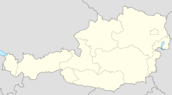
Location map of Austria
Equirectangular projection, N/S stretching 150 %. Geographic limits of the map:
- N: 49.2° N
- S: 46.3° N
- W: 9.4° E
- E: 17.2° E
Autor: Benutzer:Wald1siedel, Licence: CC BY-SA 3.0 at
Große Plaike am Ostabhang des Brucheck. nördlich des Almdorfes Königsleiten. Aufgenommen von Hochkrimml (Gerlosplatte).
Autor: Pinzgauer (talk), Licence: CC BY-SA 3.0 at
Kath. Pfarrkirche hl. Nikolaus und Friedhof
Wald im Pinzgau, village Vorderkrimml, view to ssw to the Gerloskamm of the Zillertaler Alps.
At the outmost left two summits belonging to the Venedigergruppe: Breitlahner Gabel (2601m) and Achselkogel (2666m).
In the Gerloskamm starting left: Rainbachkarkopf (2968m, also Rötenkarkopf), Hoher Schaftlkopf (3051m) and Wildkarspitze (3073m), in front of them the glacier Weißkarkees. The mountain in front of the Wildkarspitze above the tree line is the Arweskopf (2400m, also Arbeskopf). The prominent mountain right of the Wildkarspitze, separated by Seekarscharte (2519m), is the Rosskopf (2606m, shady nw-wall), followed by the Steinkarkopf (2476m) and the Schneckenköpfe.


