West Midlands (hrabství)
| West Midlands | |
|---|---|
 Noční centrum Birminghamu | |
| Geografie | |
| Hlavní město | Birmingham |
| Souřadnice | 52°30′ s. š., 1°50′ z. d. |
| Rozloha | 901,639 6 km² |
| Geodata (OSM) | OSM, WMF |
| Obyvatelstvo | |
| Počet obyvatel | 2 916 458 (2018) a 2 808 356 (2014) |
| Hustota zalidnění | 3 234,6 obyv./km² |
| Správa regionu | |
| Vznik | 1974 |
| Oficiální web | westmidlandscombinedauthority |
| Některá data mohou pocházet z datové položky. | |
West Midlands je anglické metropolitní hrabství v středozápadní Anglii. Žije zde přibližně 2,92 milionu[1] obyvatel, největší městem je Birmingham, další velká města jsou Wolverhampton a Coventry.

Celé hrabství má vysoký stupeň urbanizace a je do značné míry tvořeno právě městy. Pomineme-li Londýn, tak Birmingham s Wolverhamptonem, Black Country a Solihullem tvoří dohromady jedno z největších souměstí ve Spojeném království (vedle Velkého Manchesteru a konurbace v hrabství West Yorkshire). Jedinou větší částí, která si uchovává venkovský charakter, je severojižní 24 kilometrů široký zelený pás na jihovýchodě hrabství oddělující Coventry od birminghamského souměstí.
Administrativní členění
Hrabství se skládá ze sedmi metropolitních distriktů:
- City of Wolverhampton
- Dudley
- Walsall
- Sandwell
- City of Birmingham
- Solihull
- City of Coventry
Odkazy
Reference
- ↑ Estimates of the population for the UK, England and Wales, Scotland and Northern Ireland. Dostupné online.
Externí odkazy
 Obrázky, zvuky či videa k tématu West Midlands na Wikimedia Commons
Média použitá na této stránce
Autor: Jpb1301, Licence: CC BY-SA 3.0
Flag of the West Midlands County, England.
Autor: Nilfanion, Licence: CC BY-SA 3.0
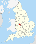
Location of the ceremonial county of the West Midlands within England.
Map of the West Midlands county; urban areas are in grey, county and borough boundaries in black, water in light-blue, motorways in deep-blue with white stripe. Includes mini-map of the United Kingdom, with the West Midland's position for context.
Autor: West Midlands Police from West Midlands, United Kingdom, Licence: CC BY-SA 2.0
Birmingham City Centre at night. The curve of the BullRing shopping centre is bottom-centre, framing the tip of the spire of St Martin's Church. To the right is the columnar Rotunda. The large white patch below-right of centre is New Street Station. In the centre, lit in red, is the Mailbox. The view is approximately to the West.


