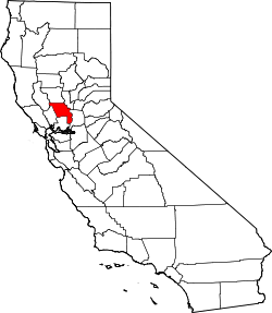
Yolo County
| Yolo County | |
|---|---|
 | |
| Geografie | |
| Hlavní město | Woodland |
| Status | okres |
| Souřadnice | 38°33′14″ s. š., 121°44′17″ z. d. |
| Rozloha | 2 649,3 km² |
| Časové pásmo | UTC-8/-7 |
| Geodata (OSM) | OSM, WMF |
| Obyvatelstvo | |
| Počet obyvatel | 200 849 (2010) |
| Hustota zalidnění | 75,8 obyv./km² |
| Správa regionu | |
| Nadřazený celek | Kalifornie |
| Vznik | 1850 |
| Oficiální web | www |
| Některá data mohou pocházet z datové položky. | |
Yolo County je okres ve státě Kalifornie v USA. K roku 2010 zde žilo 200 849 obyvatel.[1] Správním městem okresu je Woodland. Celková rozloha okresu činí 2 649,3 km².
Sousední okresy
 | Lake County | Colusa County | Sutter County |  |
| Napa County | Sacramento County | |||
| Solano County |
Reference
- ↑ Archivovaná kopie. quickfacts.census.gov [online]. [cit. 2012-01-15]. Dostupné v archivu pořízeném dne 2011-07-23.
Externí odkazy
 Obrázky, zvuky či videa k tématu Yolo County na Wikimedia Commons
Média použitá na této stránce
A stylized arrow pointing north.
A stylized arrow pointing west.
A stylized arrow pointing east.
A stylized arrow pointing south.
Vector rendering of the flag of Yolo County, California. Flag description: A flag depicting Ceres on an ivory colored field above the golden soil and below the blue sky to represent the County’s agricultural bounty was created in the 1930s to represent Yolo County at the State Fair.
Flag of California. This version is designed to accurately depict the standard print of the bear as well as adhere to the official flag code regarding the size, position and proportion of the bear, the colors of the flag, and the position and size of the star.
Yolo County Courthouse — in Woodland, Yolo County, California.
- 1917 building on the National Register of Historic Places.


