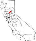
Yuba County
| Yuba County | |
|---|---|
 | |
| Geografie | |
| Hlavní město | Marysville |
| Status | okres |
| Souřadnice | 39°16′12″ s. š., 121°21′ z. d. |
| Rozloha | 1 667,3 km² |
| Časové pásmo | UTC-8/-7 |
| Geodata (OSM) | OSM, WMF |
| Obyvatelstvo | |
| Počet obyvatel | 72 155 (2010) |
| Hustota zalidnění | 43,3 obyv./km² |
| Správa regionu | |
| Nadřazený celek | Kalifornie |
| Vznik | 1850 |
| Oficiální web | www |
| Některá data mohou pocházet z datové položky. | |
Yuba County je okres ve státě Kalifornie v USA. K roku 2010 zde žilo 72 155 obyvatel.[1] Správním městem okresu je Marysville. Celková rozloha okresu činí 1 667,3 km².
Sousední okresy
 | Butte County | Plumas County a Sierra County |  | |
| Sutter County | Nevada County | |||
| Placer County |
Reference
- ↑ Archivovaná kopie. quickfacts.census.gov [online]. [cit. 2012-01-15]. Dostupné v archivu pořízeném dne 2011-07-23.
Externí odkazy
 Obrázky, zvuky či videa k tématu Yuba County na Wikimedia Commons
Média použitá na této stránce
A stylized arrow pointing north.
A stylized arrow pointing west.
A stylized arrow pointing east.
A stylized arrow pointing south.
Flag of California. This version is designed to accurately depict the standard print of the bear as well as adhere to the official flag code regarding the size, position and proportion of the bear, the colors of the flag, and the position and size of the star.
Englebright Dam and Lake on the Yuba River in the state of California, USA. The dam is located approximately 20 miles (32 km) east-northeast of Yuba City, California. The river and dam span the border between Yuba County and Nevada Counties. The dam was constructed in 1941 by the U.S. Army Corps of Engineers for flood control on the Yuba River.
This is a locator map showing Yuba County in California. For more information, see Commons:United States county locator maps.


